
This map takes into account both probability of ignition and conditional probability of spread (to 500+ acres in East and 1000+ acres in West*) given ignition.
Images
Explore our planet through photography and imagery, including climate change and water all the way back to the 1800s when the USGS was surveying the country by horse and buggy.
Filter Total Items: 21357

Fire Danger Expected Number of Fires per PSA
This map takes into account both probability of ignition and conditional probability of spread (to 500+ acres in East and 1000+ acres in West*) given ignition.

Fire Potential Index (FPI) forecast
The FPI is most similar to the Energy Release Component of the National Fire Danger Rating System in that both are moisture related indexes and neither indicates the effect of wind on fire potential.
The FPI is most similar to the Energy Release Component of the National Fire Danger Rating System in that both are moisture related indexes and neither indicates the effect of wind on fire potential.

How do lava flows cool and how long does it take?
This ‘a‘ā flow erupted from fissure 8 on Kīlauea Volcano's lower East Rift Zone on June 1, 2018, shows how the interior of a lava flow remains incandescently hot even though surface cooling forms a crust of solid rubble.
This ‘a‘ā flow erupted from fissure 8 on Kīlauea Volcano's lower East Rift Zone on June 1, 2018, shows how the interior of a lava flow remains incandescently hot even though surface cooling forms a crust of solid rubble.

Large Fire Probability
This map takes into account both probability of ignition and conditional probability of spread (to 500+ acres in East and 1000+ acres in West*) given ignition.
This map takes into account both probability of ignition and conditional probability of spread (to 500+ acres in East and 1000+ acres in West*) given ignition.

USGS Fire Danger Forecast Large Fire Probability
Large Fire Probability for August 30, 2018. Percent change estimate, given a source for ignition that a fire will grow to 100+ acres.
Large Fire Probability for August 30, 2018. Percent change estimate, given a source for ignition that a fire will grow to 100+ acres.

Historic Distribution of 100+ acres Fires per Forthcoming Week
Historic Distribution of 100+ acres Fires per Forthcoming WeekSummary of Fires by GACC Units: For the week of 08/29/2018
Historic Distribution of 100+ acres Fires per Forthcoming Week
Historic Distribution of 100+ acres Fires per Forthcoming WeekSummary of Fires by GACC Units: For the week of 08/29/2018

Low sulfur emissions mean a new focus on a different volcanic gas
Low sulfur emissions mean a new focus on a different volcanic gasA USGS pilot and Hawaiian Volcano Observatory gas geochemist prepare to conduct a test flight of an unmanned aerial system (UAS) on Kīlauea Volcano in November 2018. This UAS was outfitted with a prototype miniaturized multi-gas sensor for the detection of volcanic gases emitted by Kīlauea, including sulfur dioxide and carbon dioxide.

Array of photovoltaic cells and a wind energy facility
Array of photovoltaic cells and a wind energy facilityPhotovoltaic, or solar, cells array at the Ivanpah Solar Power Facility in the Mojave Desert and a wind energy facility in the Northeastern United States.
Array of photovoltaic cells and a wind energy facility
Array of photovoltaic cells and a wind energy facilityPhotovoltaic, or solar, cells array at the Ivanpah Solar Power Facility in the Mojave Desert and a wind energy facility in the Northeastern United States.

Erosion has taken a toll on this Keys coral
A reef in the Florida Keys National Marine Sanctuary with little living coral and extensive bioerosion. Photo taken under research permit number FKNMS-2016-085-A1. Credit: USGS, Ilsa Kuffner.
A reef in the Florida Keys National Marine Sanctuary with little living coral and extensive bioerosion. Photo taken under research permit number FKNMS-2016-085-A1. Credit: USGS, Ilsa Kuffner.

Salamander sampling crew
Northeast Region Photo Contest Winner | October 2018 | People
Salamander sampling crew
Northeast Region Photo Contest Winner | October 2018 | People
Salamander sampling crew

Atlantic Spotted Dolphins
Atlantic spotted dolphins photographed near the R/V Hugh R. Sharp on August 27, 2018 by the protected species visual observers.
Atlantic spotted dolphins photographed near the R/V Hugh R. Sharp on August 27, 2018 by the protected species visual observers.

Audience at California's Premier Adaptation Gathering
Audience at California's Premier Adaptation GatheringAudience at California's Premier Adaptation Gathering
Audience at California's Premier Adaptation Gathering
Audience at California's Premier Adaptation GatheringAudience at California's Premier Adaptation Gathering

Audience at California's Premier Adaptation Gathering
Audience at California's Premier Adaptation GatheringAudience at California's Premier Adaptation Gathering
Audience at California's Premier Adaptation Gathering
Audience at California's Premier Adaptation GatheringAudience at California's Premier Adaptation Gathering

A fisheries technician prepares to release a tagged pallid sturgeon
A fisheries technician prepares to release a tagged pallid sturgeonA fisheries technician prepares to release a tagged pallid sturgeon into the Yellowstone River, Montana
A fisheries technician prepares to release a tagged pallid sturgeon
A fisheries technician prepares to release a tagged pallid sturgeonA fisheries technician prepares to release a tagged pallid sturgeon into the Yellowstone River, Montana

50,000 tons of sulfur dioxide gas per day
In mid-July 2018, fissure 8 (shown here) on Kīlauea Volcano's lower East Rift Zone was emitting more than 50,000 tons of sulfur dioxide gas per day, creating high levels of vog on the island. Since early August, lower East Rift Zone SO2 emissions have dropped to less than 100 tons per day, resulting in better air quality for Hawaii.
In mid-July 2018, fissure 8 (shown here) on Kīlauea Volcano's lower East Rift Zone was emitting more than 50,000 tons of sulfur dioxide gas per day, creating high levels of vog on the island. Since early August, lower East Rift Zone SO2 emissions have dropped to less than 100 tons per day, resulting in better air quality for Hawaii.

Impact of Hurricane Lane on Wailuku River
Two views from the Rainbow Falls overlook, downstream of the Wailuku River streamgage near Hilo, Hawaii. The image on the left shows a typical base flow of about 35 cubic feet per second (cfs). The image on the right shows the early impact of Hurricane Lane with a flow of about 26,000 cfs taken at 8:35 a.m. HST, August 23, 2018. This U.S.
Two views from the Rainbow Falls overlook, downstream of the Wailuku River streamgage near Hilo, Hawaii. The image on the left shows a typical base flow of about 35 cubic feet per second (cfs). The image on the right shows the early impact of Hurricane Lane with a flow of about 26,000 cfs taken at 8:35 a.m. HST, August 23, 2018. This U.S.

Skinny Common Murre flying with keel protruding
Skinny Common Murre with keel protruding. Lower Cook Inlet, Alaska
Skinny Common Murre with keel protruding. Lower Cook Inlet, Alaska

View of Unalakleet from the air
Unalakleet village on the low-lying barrier spit at the inlet of the Unalakleet River and Norton Sound, Alaska.
Unalakleet village on the low-lying barrier spit at the inlet of the Unalakleet River and Norton Sound, Alaska.

Why do some Hawaii earthquakes occur so far offshore?
Why do some Hawaii earthquakes occur so far offshore?Many of the earthquakes in Hawaii that extend offshore and up the island chain are due to plate bending, or flexure. The upper panel shows magnitude-5 and greater earthquakes since 1861, with some notable events labeled.
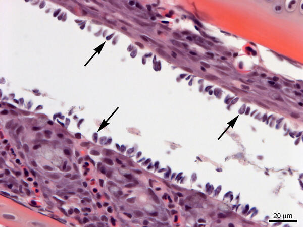
Gills from Lost River Suckers - heavy infestation of Ichthyobodo sp.
Gills from Lost River Suckers - heavy infestation of Ichthyobodo sp.Gills from Lost River suckers with a heavy infestation of Ichthyobodo sp. (arrows). Slide is stained with hematoxylin and eosin.
Gills from Lost River Suckers - heavy infestation of Ichthyobodo sp.
Gills from Lost River Suckers - heavy infestation of Ichthyobodo sp.Gills from Lost River suckers with a heavy infestation of Ichthyobodo sp. (arrows). Slide is stained with hematoxylin and eosin.

A Peregrine Falcon flies off with a Black-legged Kittiwake
A Peregrine Falcon flies off with a Black-legged KittiwakeA Peregrine Falcon flies off with a Black-legged Kittiwake from its colony at Gull Island, Alaska.
A Peregrine Falcon flies off with a Black-legged Kittiwake
A Peregrine Falcon flies off with a Black-legged KittiwakeA Peregrine Falcon flies off with a Black-legged Kittiwake from its colony at Gull Island, Alaska.