
Twentymile River sonar on a bridge
Images
Explore our planet through photography and imagery, including climate change and water all the way back to the 1800s when the USGS was surveying the country by horse and buggy.
Filter Total Items: 21356

Twentymile River sonar on a bridge
Twentymile River sonar on a bridge
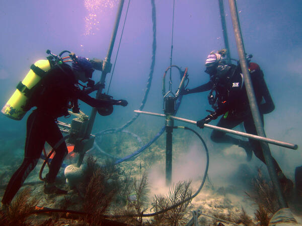
USGS scientists drill a coral-reef core in the Florida Keys
USGS scientists drill a coral-reef core in the Florida KeysResearch Oceanographer Lauren Toth and student volunteer Liz Whitcher drill a coral-reef core from a reef off Key West, Florida, in the Florida Keys National Marine Sanctuary. Photo taken under research permit FKNMS-2015-058. Credit: Anastasios Stathakopoulos, USGS.

Yellowstone National Park Dragonfly Mercury Project Sampling
Yellowstone National Park Dragonfly Mercury Project SamplingThis image shows citizen scientists along with National Park Service personnel identifying invertebrates as part of the Dragonfly Mercury Project.
Yellowstone National Park Dragonfly Mercury Project Sampling
Yellowstone National Park Dragonfly Mercury Project SamplingThis image shows citizen scientists along with National Park Service personnel identifying invertebrates as part of the Dragonfly Mercury Project.

7 months of no lava at Pu‘u ‘Ō‘ō heralds end of an e
7 months of no lava at Pu‘u ‘Ō‘ō heralds end of an ePu‘u ‘Ō‘ō on May 3, 2018, as viewed from the helicopter overflight. The crater floor is collapsed, and a thin plume escapes from the gaping crater. The west flank cracked on April 30th around 2:30 pm HST, and minor amounts of lava oozed out of the crack (line of steaming features) just before the plumbing system catastrophically failed.

A sensor data logger recovered from the floor of Yellowstone Lake in the Deep Ho
A sensor data logger recovered from the floor of Yellowstone Lake in the Deep HoA sensor data logger recovered from the floor of Yellowstone Lake in the Deep Hole area in 2018 shows signs of melting due to unexpectedly high temperatures in sediments up to ~3 ft (1 m) away from an active hydrothermal vent. Image acquired by the Global Foundation for Ocean Exploration ROV Yogi on August 4, 2018.

Hot spring waters with relatively high dissolved element concentrations on the f
Hot spring waters with relatively high dissolved element concentrations on the fHot spring waters with relatively high dissolved element concentrations on the floor of West Thumb, Yellowstone Lake. Image acquired by the Global Foundation for Ocean Exploration ROV Yogi on August 7, 2018.

InSAR image of Yellowstone spanning 2004-2006
Color bands in this radar interferogram depict the pattern of surface deformation at the Yellowstone caldera from September 22, 2004, to August 23, 2006. The southwest and northeast parts of the caldera floor rose about 11 cm (4.3 inches) and 15 cm (5.9 inches), respectively, while the north caldera rim near Norris Geyser Basin subsided about 7 cm (2.8 inches).
Color bands in this radar interferogram depict the pattern of surface deformation at the Yellowstone caldera from September 22, 2004, to August 23, 2006. The southwest and northeast parts of the caldera floor rose about 11 cm (4.3 inches) and 15 cm (5.9 inches), respectively, while the north caldera rim near Norris Geyser Basin subsided about 7 cm (2.8 inches).

Scientific crew and drone operators
Scientific crew and drone operators. Left to right: Richard Kolyer (NASA), Jack McFarland (USGS), Kristen Manies (USGS), and Jonas Jonsson (NASA)
Scientific crew and drone operators. Left to right: Richard Kolyer (NASA), Jack McFarland (USGS), Kristen Manies (USGS), and Jonas Jonsson (NASA)

Kīlauea summit
At Kīlauea's summit today, a clear morning gave way to heavy rain, which re-mobilized the ash cover between HVO and the Southwest Rift Zone, concentrating the ash in washes.
At Kīlauea's summit today, a clear morning gave way to heavy rain, which re-mobilized the ash cover between HVO and the Southwest Rift Zone, concentrating the ash in washes.

Assessing bridge scour countermeasures
USGS hydrologist Taylor Dudunake assesses the rip-rap countermeasure along the pier of the Iowa State Route 76 bridge over the Upper Iowa River near Dorchester, Iowa. The assessment was part of a nationwide study of bridge scour countermeasures the USGS conducted on behalf of the Federal Highway Administration.
USGS hydrologist Taylor Dudunake assesses the rip-rap countermeasure along the pier of the Iowa State Route 76 bridge over the Upper Iowa River near Dorchester, Iowa. The assessment was part of a nationwide study of bridge scour countermeasures the USGS conducted on behalf of the Federal Highway Administration.

Catherine Fargen and Moriah Will making a groundwater measurement
Catherine Fargen and Moriah Will making a groundwater measurementCatherine Fargen and Moriah Will making a groundwater measurement.
Catherine Fargen and Moriah Will making a groundwater measurement
Catherine Fargen and Moriah Will making a groundwater measurementCatherine Fargen and Moriah Will making a groundwater measurement.

Catherine Fargen and Moriah Will securing a well from floodwaters
Catherine Fargen and Moriah Will securing a well from floodwatersCatherine Fargen and Moriah Will securing a well from floodwaters.
Catherine Fargen and Moriah Will securing a well from floodwaters
Catherine Fargen and Moriah Will securing a well from floodwatersCatherine Fargen and Moriah Will securing a well from floodwaters.

Deploying two seismic sources
Jenny McKee and Peter Dal Farro of the USGS Pacific Coastal and Marine Science Center swing a pair of seismic sources, also called air guns, and the gun hanger, out over the water to deploy them during the 2018 MATRIX cruise. Scripps Institution of Oceanography's seismic streamer is coiled on the blue winch in the foreground.
Jenny McKee and Peter Dal Farro of the USGS Pacific Coastal and Marine Science Center swing a pair of seismic sources, also called air guns, and the gun hanger, out over the water to deploy them during the 2018 MATRIX cruise. Scripps Institution of Oceanography's seismic streamer is coiled on the blue winch in the foreground.

Diesel Compressors
Four diesel-powered compressors chained to the deck of the R/V Hugh R. Sharp provided the air to power the seismic sources during the MATRIX cruise.
Four diesel-powered compressors chained to the deck of the R/V Hugh R. Sharp provided the air to power the seismic sources during the MATRIX cruise.

Fissure 8 lava channel
The fissure 8 lava channel remains inactive and continues to cool.
The fissure 8 lava channel remains inactive and continues to cool.

Kīlauea summit
Kīlauea Volcano’s summit, seen here from the northeast rim of the caldera, has remained quiet, with no collapse events since August 2. It remains too soon to tell if this diminished activity represents a temporary lull or the end of summit collapses.
Kīlauea Volcano’s summit, seen here from the northeast rim of the caldera, has remained quiet, with no collapse events since August 2. It remains too soon to tell if this diminished activity represents a temporary lull or the end of summit collapses.

Retrieving airguns
Jenny White McKee and Pete Dal Ferro of the Pacific Coastal and Marine Science Center retrieve two airguns during the 2018 MATRIX cruise aboard the R/V Hugh R. Sharp. The seismic streamer is visible on the winch in the foreground.
Jenny White McKee and Pete Dal Ferro of the Pacific Coastal and Marine Science Center retrieve two airguns during the 2018 MATRIX cruise aboard the R/V Hugh R. Sharp. The seismic streamer is visible on the winch in the foreground.

A RestoreNet Garden on the Colorado Plateau
A completed restoration field trial site just after installation. Half of the site is seeded, and the other half had plants and weed cloth (white fabric) installed.
A completed restoration field trial site just after installation. Half of the site is seeded, and the other half had plants and weed cloth (white fabric) installed.

Installing a restoration field trial site
These workers are planting seedlings as part of the restoration field trial network. Each garden in the network is examining seedlings and seeds in conjunction with restoration treatments to better und
These workers are planting seedlings as part of the restoration field trial network. Each garden in the network is examining seedlings and seeds in conjunction with restoration treatments to better und

Seeding treatment experiment
View of a recently installed Restoration Field Trial Network site in the rangelands of Northern Arizona.
View of a recently installed Restoration Field Trial Network site in the rangelands of Northern Arizona.