U.S. flag

An official website of the United States government

Images

Explore our planet through photography and imagery, including climate change and water all the way back to the 1800s when the USGS was surveying the country by horse and buggy.

Filter Total Items: 21394
Mangrove forests with water in the foreground and forest with dense aboveground roots
Mangrove trees in Micronesia

Mangrove forest in Micronesia.

The USGS and partners are studying how mangrove forests in the Federated States of Micronesia may respond to sea-level rise over the coming century. Their projections will help Micronesian communities plan for the future.

Mangrove forest in Micronesia.

The USGS and partners are studying how mangrove forests in the Federated States of Micronesia may respond to sea-level rise over the coming century. Their projections will help Micronesian communities plan for the future.

A map shows islands plotted on a latitude and longitude scale with colors that show varying ocean depth.
Overview of Hawaii high-resolution SWAN model grids

Overview of the high-resolution model grids from: “Dynamically downscaled future wave projections from SWAN model results for the main Hawaiian Islands”

There is a short window of opportunity to complete glacier repeat photography.
Short window of opportunity to complete glacier repeat photo

There is a short window of opportunity to complete glacier repeat photography.  Scientists must wait until late summer, when seasonal snow has melted from the glacier surface and glacier margins can be identified.  This is also the time of year when weather and forest fire smoke can hamper photography and hiking.

There is a short window of opportunity to complete glacier repeat photography.  Scientists must wait until late summer, when seasonal snow has melted from the glacier surface and glacier margins can be identified.  This is also the time of year when weather and forest fire smoke can hamper photography and hiking.

USGS employee taking repeat photo of glaciers

USGS employee captures a repeat photo of Grinnell and Salamander Glaciers from the summit of Mt. Gould in Glacier National Park.

USGS employee captures a repeat photo of Grinnell and Salamander Glaciers from the summit of Mt. Gould in Glacier National Park.

Two photos of red well piping in basement of building. In one photo, scientist is preparing to to take water-level measurements.
USGS Groundwater Well Dates Back to 1874 (NWIS Site 430429089230301)

The first USGS groundwater level measurement recorded in this well is from 1874! The well was originally a flowing artesian well that was used as an active water supply. Routine monitoring began in 1946.

The first USGS groundwater level measurement recorded in this well is from 1874! The well was originally a flowing artesian well that was used as an active water supply. Routine monitoring began in 1946.

A group of people works together in a mangrove forest
Working together in the mangrove forest

Members of the Micronesian Conservation Trust and other partners assist with fieldwork in the mangrove forest.

The USGS and partners are studying how mangrove forests in the Federated States of Micronesia may respond to sea-level rise over the coming century. Their projections will help Micronesian communities plan for the future.

Members of the Micronesian Conservation Trust and other partners assist with fieldwork in the mangrove forest.

The USGS and partners are studying how mangrove forests in the Federated States of Micronesia may respond to sea-level rise over the coming century. Their projections will help Micronesian communities plan for the future.

exposed ablation stake in the fall at Wolverine Glacier
Ablation Stake on Wolverine Glacier

An ablation stake which began the summer below the surface of the snow is shown here in the fall, extending far above bare ice surface of Wolverine Glacier, Alaska. A USGS scientist carries a portable steam drill, used to install the stakes in the glacier.

An ablation stake which began the summer below the surface of the snow is shown here in the fall, extending far above bare ice surface of Wolverine Glacier, Alaska. A USGS scientist carries a portable steam drill, used to install the stakes in the glacier.

image related to volcanoes. See description
Civil Air Patrol captured this aerial image of Mauna Loa's summit caldera, Moku&

Civil Air Patrol captured this aerial image of Mauna Loa's summit caldera, Moku‘āweoweo, on Sunday, October 20, 2019. The true summit of Mauna Loa is located just to the right of the center of the image, at the highest location above the caldera wall in the background.

Civil Air Patrol captured this aerial image of Mauna Loa's summit caldera, Moku‘āweoweo, on Sunday, October 20, 2019. The true summit of Mauna Loa is located just to the right of the center of the image, at the highest location above the caldera wall in the background.

J. Mitchell Doyle swamped in soil on the Pamunkey River, VA

Photo Contest Winner | Dec. 2019 | People
J. Mitchell Doyle swamped in soil on the Pamunkey River, VA

view looking north across Mauna Loa's summit caldera
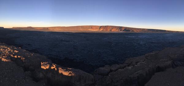
early morning view looking north across Moku‘āweoweo

An early morning view looking north across Moku‘āweoweo, Mauna Loa's summit caldera, from a spot near the summit cabin on the volcano's south caldera rim. Frost covered much of the caldera floor that was still shadowed, and weak steaming issued from the usual areas. Overall, there were no significant changes observed at the summit.

An early morning view looking north across Moku‘āweoweo, Mauna Loa's summit caldera, from a spot near the summit cabin on the volcano's south caldera rim. Frost covered much of the caldera floor that was still shadowed, and weak steaming issued from the usual areas. Overall, there were no significant changes observed at the summit.

An exploration of the direct and indirect effects of climatic warming on arctic lake ecosystems
An exploration of the direct and indirect effects of climatic warming

Arctic lakes support trophic interactions, biological processes, and critical habitat at all trophic levels; however, climatic warming threatens to alter the structure and function of aquatic communities and overall system production.

Arctic lakes support trophic interactions, biological processes, and critical habitat at all trophic levels; however, climatic warming threatens to alter the structure and function of aquatic communities and overall system production.

Horiba Aqaulog - simultaneously measures absorbance spectra and fluorescence Excitation-Emission Matrices
Horiba Aqaulog
Horiba Aqaulog
Horiba Aqaulog

Horiba Aqaulog - simultaneously measures absorbance spectra and fluorescence

Horiba Aqaulog - simultaneously measures absorbance spectra and fluorescence

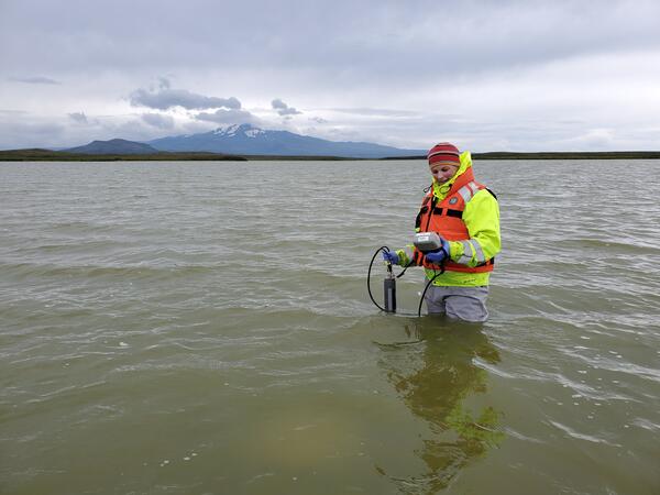
Water chemistry measurements on the Alaska Peninsula
Hydrologist takes water chemistry measures on the Alaska Peninsula

Laura Hubbard of the USGS Upper Midwest Water Science Center takes water chemistry measures on the Alaska Peninsula as part of research to understand how long influenza viruses remain viable in the environment.  

Laura Hubbard of the USGS Upper Midwest Water Science Center takes water chemistry measures on the Alaska Peninsula as part of research to understand how long influenza viruses remain viable in the environment.  

Sean Egen, hydrologic technician, installs a storm tide sensor at River Dunes Marina in Pamlico County, NC
Storm Tide Sensor Installation, Pamlico County, NC

Sean Egen, hydrologic technician, installs a storm tide sensor
at River Dunes Marina in Pamlico County, NC

USGS technician on a bridge with instruments and laptop
Adding a rapid deployment gauge to track Dorian's surge in Virginia

Hydrographer Keith Lambert installing a rapid deployment gage at New Mill Creek at Chesapeake, VA in advance of Hurricane Dorian. Photo: Blake Dudding, USGS September 5, 2019

image related to volcanoes. See description
Continued slow rise of water level at bottom of Halema‘uma‘u

The water level at Kīlauea summit continues to slowly rise, with the size of the pond gradually enlarging. The pond today was at least 140 m (460 ft) in the east-west direction (from bottom to top of image). This length is a minimum estimate as the west end of the pond is now partially blocked from view by the crater walls. USGS photo by D. Swanson.

The water level at Kīlauea summit continues to slowly rise, with the size of the pond gradually enlarging. The pond today was at least 140 m (460 ft) in the east-west direction (from bottom to top of image). This length is a minimum estimate as the west end of the pond is now partially blocked from view by the crater walls. USGS photo by D. Swanson.

image related to volcanoes. See description
High Altitude Station Maintenance on Mauna Loa

Sulphur Cone (left), viewed toward southwest, from 3,480 m (11,420 ft) above sea level on Mauna Loa's southwest rift zone. At right, an HVO geoscientist and technician rebuild volcanic gas monitoring equipment installed near an outgassing fissure.

Sulphur Cone (left), viewed toward southwest, from 3,480 m (11,420 ft) above sea level on Mauna Loa's southwest rift zone. At right, an HVO geoscientist and technician rebuild volcanic gas monitoring equipment installed near an outgassing fissure.

People work together to install a water logger in the mangrove forest
Installing a water logger in the mangrove forest

USGS and partners work together to install water loggers in the mangrove forest.

The USGS and partners are studying how mangrove forests in the Federated States of Micronesia may respond to sea-level rise over the coming century. Their projections will help Micronesian communities plan for the future.

USGS and partners work together to install water loggers in the mangrove forest.

The USGS and partners are studying how mangrove forests in the Federated States of Micronesia may respond to sea-level rise over the coming century. Their projections will help Micronesian communities plan for the future.

Was this page helpful?