
Mohawk River Ice Jam at Lock 8 in Schenectady, NY near USGS gaging station 01354330
Images
Explore our planet through photography and imagery, including climate change and water all the way back to the 1800s when the USGS was surveying the country by horse and buggy.
Filter Total Items: 21343

Mohawk River Ice Jam at Lock 8 in Schenectady, NY
Mohawk River Ice Jam at Lock 8 in Schenectady, NY near USGS gaging station 01354330
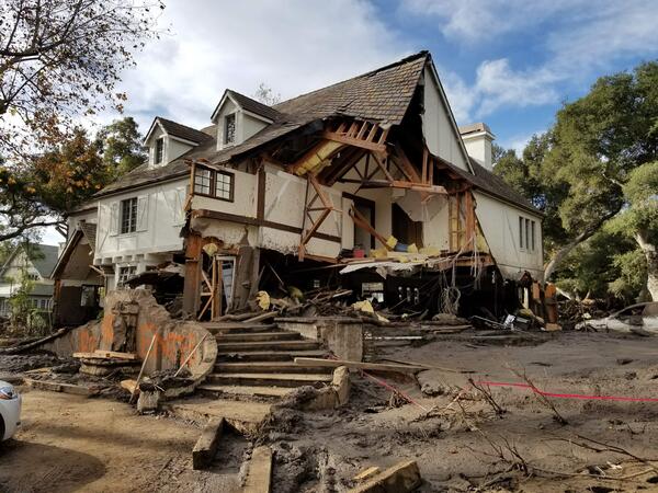
Montecito home damaged by post-wildfire debrisflow.
Montecito home damaged by post-wildfire debrisflow.Damage from a major post-wildfire landslide that occurred on 9 January 2018 near Montecito, Santa Barbara County as a result of the 2017 Thomas Fire.
Montecito home damaged by post-wildfire debrisflow.
Montecito home damaged by post-wildfire debrisflow.Damage from a major post-wildfire landslide that occurred on 9 January 2018 near Montecito, Santa Barbara County as a result of the 2017 Thomas Fire.

USGS St. Petersburg Coastal and Marine Science Center
USGS St. Petersburg Coastal and Marine Science CenterUSGS St. Petersburg Coastal and Marine Science Center
USGS St. Petersburg Coastal and Marine Science Center
USGS St. Petersburg Coastal and Marine Science CenterUSGS St. Petersburg Coastal and Marine Science Center

Water truly does make the desert bloom.
Nile Valley in Egypt—Water makes the desert bloom
Nile Valley in Egypt—Water makes the desert bloom

Doublet Pool, fringed by geyserite, in the Upper Geyser Basin of YNP.
Doublet Pool, fringed by geyserite, in the Upper Geyser Basin of YNP.Doublet Pool, fringed by geyserite, in the Upper Geyser Basin of Yellowstone National Park. National Park Service photograph by Jacob Frank.
Doublet Pool, fringed by geyserite, in the Upper Geyser Basin of YNP.
Doublet Pool, fringed by geyserite, in the Upper Geyser Basin of YNP.Doublet Pool, fringed by geyserite, in the Upper Geyser Basin of Yellowstone National Park. National Park Service photograph by Jacob Frank.

Eagle Creek above Findlay OH - ice and snow covered stream downstream
Eagle Creek above Findlay OH - ice and snow covered stream downstreamEagle Creek above Findlay OH - ice and snow covered stream downstream of gage
Eagle Creek above Findlay OH - ice and snow covered stream downstream
Eagle Creek above Findlay OH - ice and snow covered stream downstreamEagle Creek above Findlay OH - ice and snow covered stream downstream of gage

Eagle Creek above Findlay OH - snow covered stream downstream of gage
Eagle Creek above Findlay OH - snow covered stream downstream of gageEagle Creek above Findlay OH - snow covered stream downstream of gage
Eagle Creek above Findlay OH - snow covered stream downstream of gage
Eagle Creek above Findlay OH - snow covered stream downstream of gageEagle Creek above Findlay OH - snow covered stream downstream of gage

Geologists assess damage after debris-flow event
USGS geologists deployed to Santa Barbara County to support a geohazard assessment of the Montecito area
USGS geologists deployed to Santa Barbara County to support a geohazard assessment of the Montecito area

Geologists assess scene after debris flow
Geologists assess boulders displaced during the Montecito debris flow event on Jan. 9, 2018.
Geologists assess boulders displaced during the Montecito debris flow event on Jan. 9, 2018.

Montecito after debris flow
The Dec. 4, 2017 Thomas fire, Southern California's largest wildfire on record, burned more than 280,000 acres across Ventura and Santa Barbara counties for nearly a month.
The Dec. 4, 2017 Thomas fire, Southern California's largest wildfire on record, burned more than 280,000 acres across Ventura and Santa Barbara counties for nearly a month.

Pool sign warns first responders
Swimming pool sign spray-painted to warn first responders and others to be careful around the potentially dangerous area.
Swimming pool sign spray-painted to warn first responders and others to be careful around the potentially dangerous area.

Theewaterskloof Reservoir, South Africa
A three-year drought is threatening to cause city officials in Cape Town, South Africa, to shut off the tap water. The growing city of nearly 4 million relies mostly on reservoirs for its water supply. While drought is part of the cause of the current crisis, an increasing population is also straining water resources.
A three-year drought is threatening to cause city officials in Cape Town, South Africa, to shut off the tap water. The growing city of nearly 4 million relies mostly on reservoirs for its water supply. While drought is part of the cause of the current crisis, an increasing population is also straining water resources.

Oil Fires in Iraq
Over the past few years, black smoke has been seen in satellite images billowing from various locations in Iraq. As Iraqi forces drive ISIS away, the terrorist group has been setting oil wells on fire as it retreats.
Over the past few years, black smoke has been seen in satellite images billowing from various locations in Iraq. As Iraqi forces drive ISIS away, the terrorist group has been setting oil wells on fire as it retreats.

Eagle Creek above Findlay OH - USGS staff making a wading measurement
Eagle Creek above Findlay OH - USGS staff making a wading measurementEagle Creek above Findlay OH - USGS staff making a wading measurement
Eagle Creek above Findlay OH - USGS staff making a wading measurement
Eagle Creek above Findlay OH - USGS staff making a wading measurementEagle Creek above Findlay OH - USGS staff making a wading measurement

Eagle Creek above Findlay OH - view of stream with ice on it
Eagle Creek above Findlay OH - view of stream with ice on itEagle Creek above Findlay OH - view of stream with ice on it
Eagle Creek above Findlay OH - view of stream with ice on it
Eagle Creek above Findlay OH - view of stream with ice on itEagle Creek above Findlay OH - view of stream with ice on it

Auguring holes to measure streamflow, Blacks Fork Robertson
Auguring holes to measure streamflow, Blacks Fork RobertsonAuguring holes to measure streamflow, Blacks Fork Robertson
Auguring holes to measure streamflow, Blacks Fork Robertson
Auguring holes to measure streamflow, Blacks Fork RobertsonAuguring holes to measure streamflow, Blacks Fork Robertson

Chopping ice to create open channel to measure streamflow, Blacks Fk
Chopping ice to create open channel to measure streamflow, Blacks FkChopping ice to create open channel to measure streamflow, Blacks Fk
Chopping ice to create open channel to measure streamflow, Blacks Fk
Chopping ice to create open channel to measure streamflow, Blacks FkChopping ice to create open channel to measure streamflow, Blacks Fk

Erika Lentz interview by WBZ Meteorologist, Danielle Niles
Erika Lentz interview by WBZ Meteorologist, Danielle NilesResearch geologist, Erika Lentz, interviewed on Trunk River Beach, Falmouth, MA, by WBZ meterologist, Danielle Niles, about the future impacts of sea-level rise
Erika Lentz interview by WBZ Meteorologist, Danielle Niles
Erika Lentz interview by WBZ Meteorologist, Danielle NilesResearch geologist, Erika Lentz, interviewed on Trunk River Beach, Falmouth, MA, by WBZ meterologist, Danielle Niles, about the future impacts of sea-level rise

Erika Lentz is interviewed by WBZ Boston for a sea-level rise segment
Erika Lentz is interviewed by WBZ Boston for a sea-level rise segmentErika Lentz, Woods Hole Coastal and Marine Science Center Research Geologist interviewed by WBZ Boston Meterologist, Danielle Niles fora segment on sea-level rise
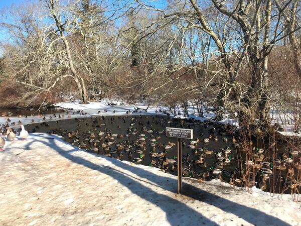
Hook Pond Dreen at Davids Lane, East Hampton, New York
Hook Pond Dreen at Davids Lane, East Hampton, New YorkDucks in Hook Pond Dreen at Davids Lane, East Hampton, New York
Hook Pond Dreen at Davids Lane, East Hampton, New York
Hook Pond Dreen at Davids Lane, East Hampton, New YorkDucks in Hook Pond Dreen at Davids Lane, East Hampton, New York

Licking River at Highway 536 near Alexandria, Kentucky
Licking River at Highway 536 near Alexandria, KentuckyLicking River at Highway 536 near Alexandria, Kentucky gage, looking downstream from the gage location.
Licking River at Highway 536 near Alexandria, Kentucky
Licking River at Highway 536 near Alexandria, KentuckyLicking River at Highway 536 near Alexandria, Kentucky gage, looking downstream from the gage location.