Seismicity rates for Yellowstone Lake earthquake swarms
Seismicity rates for Yellowstone Lake earthquake swarmsRate of earthquake occurrence for the 2008-2009 Yellowstone Lake swarm (green) and 2020 swarm (red).

Official websites use .gov
A .gov website belongs to an official government organization in the United States.
Secure .gov websites use HTTPS
A lock () or https:// means you’ve safely connected to the .gov website. Share sensitive information only on official, secure websites.
Explore our planet through photography and imagery, including climate change and water all the way back to the 1800s when the USGS was surveying the country by horse and buggy.

Rate of earthquake occurrence for the 2008-2009 Yellowstone Lake swarm (green) and 2020 swarm (red).
Rate of earthquake occurrence for the 2008-2009 Yellowstone Lake swarm (green) and 2020 swarm (red).
ANIMATED GIF: At Kīlauea summit, the KWcam webcam recorded several small color changes along the lake margin following rockfalls which impacted the lake surface. These rockfalls immediately followed a M3.1 earthquake Wednesday evening, December 2, at 5:59 p.m. HST. This animated image file (GIF) continuously loops two consecutive webcam images from 5:50 p.m.
ANIMATED GIF: At Kīlauea summit, the KWcam webcam recorded several small color changes along the lake margin following rockfalls which impacted the lake surface. These rockfalls immediately followed a M3.1 earthquake Wednesday evening, December 2, at 5:59 p.m. HST. This animated image file (GIF) continuously loops two consecutive webcam images from 5:50 p.m.

KWcam webcam image from December 2 at 6:00 p.m. HST, immediately following a M3.1 earthquake at Kīlauea summit. Several rockfalls down the talus slope impacted the summit water lake, causing some brief localized color changes of the lake surface (circled in yellow).
KWcam webcam image from December 2 at 6:00 p.m. HST, immediately following a M3.1 earthquake at Kīlauea summit. Several rockfalls down the talus slope impacted the summit water lake, causing some brief localized color changes of the lake surface (circled in yellow).

A) Conditions during a 2015 munitions mobility experiment in Duck, NC, and B) cartographic visualization of hindcast probability of munitions’ complete burial during the experiment.
A) Conditions during a 2015 munitions mobility experiment in Duck, NC, and B) cartographic visualization of hindcast probability of munitions’ complete burial during the experiment.

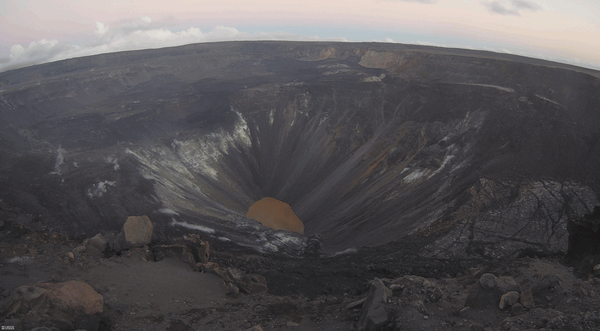
This photo was taken from the west rim of Kīlauea caldera at dawn, and shows the moon setting over Mauna Loa's broad Northeast Rift Zone. USGS photo by M. Patrick.
This photo was taken from the west rim of Kīlauea caldera at dawn, and shows the moon setting over Mauna Loa's broad Northeast Rift Zone. USGS photo by M. Patrick.

Photographs from a red wolf (Canis rufus) found dead in North Carolina, USA. (A) Adult heartworms (Dirolfilaria immitis) in the right ventricle and atria of the heart and extending into the pulmonary artery. (B) Hard, haired nodule on the medial surface of the distal radius of the right leg.
Photographs from a red wolf (Canis rufus) found dead in North Carolina, USA. (A) Adult heartworms (Dirolfilaria immitis) in the right ventricle and atria of the heart and extending into the pulmonary artery. (B) Hard, haired nodule on the medial surface of the distal radius of the right leg.

The U.S. Geological Survey St. Petersburg Coastal and Marine Science Center is conducting research to guide the restoration and recovery of the threatened elkhorn coral, Acropora palmata, in Dry Tortugas National Park and throughout the western Atlantic.
The U.S. Geological Survey St. Petersburg Coastal and Marine Science Center is conducting research to guide the restoration and recovery of the threatened elkhorn coral, Acropora palmata, in Dry Tortugas National Park and throughout the western Atlantic.

Restoring areas infested with invasive species that carry catastrophic fire is a top priority for the Restoration Assessment and Monitoring Program for the Southest (RAMPS) and our partners.
Restoring areas infested with invasive species that carry catastrophic fire is a top priority for the Restoration Assessment and Monitoring Program for the Southest (RAMPS) and our partners.

Tephra layers preserved at the summit of Kīlauea from at least three different eruptions. Deposits below the top of the scale are predominantly juvenile and deposits above it containing many lithics. Notice the larger size of the yellow pumice clasts compared to the much denser and finer grey lapilli and ash surrounding them from 7 to 18 on the scale.
Tephra layers preserved at the summit of Kīlauea from at least three different eruptions. Deposits below the top of the scale are predominantly juvenile and deposits above it containing many lithics. Notice the larger size of the yellow pumice clasts compared to the much denser and finer grey lapilli and ash surrounding them from 7 to 18 on the scale.

Lidar hillshade map of part of the Blackfoot Volcanic Field, showing rhyolite domes and fault scarps.
Lidar hillshade map of part of the Blackfoot Volcanic Field, showing rhyolite domes and fault scarps.

Map of southeastern Idaho showing volcanic rocks related to the Yellowstone hotspot. Basalt is shown in red and rhyolite in yellow. Blue circles indicate the location of past Yellowstone calderas; caldera names and approximate ages are shown (Ma = million years old).
Map of southeastern Idaho showing volcanic rocks related to the Yellowstone hotspot. Basalt is shown in red and rhyolite in yellow. Blue circles indicate the location of past Yellowstone calderas; caldera names and approximate ages are shown (Ma = million years old).

Photo Contest Winner | June 2021 | People
Neal Craig teaching new hydro tech Alice Mower at Fisherville, KY gage
Photo Contest Winner | June 2021 | People
Neal Craig teaching new hydro tech Alice Mower at Fisherville, KY gage

Far out, man... where science meets art

Photo Contest Winner | January 2021 | Honorable Mention 1
Teaching young techs how to count clicks
Photo Contest Winner | January 2021 | Honorable Mention 1
Teaching young techs how to count clicks

White River spinedace. Photo taken Wayne E. Kirch Wildlife Management Area, Lund, NV.
White River spinedace. Photo taken Wayne E. Kirch Wildlife Management Area, Lund, NV.

Passive integrated transponder detection antenna located in the Flag Springs Complex in eastern Nevada. This is the only place on earth where White River spinedace still exist.
Passive integrated transponder detection antenna located in the Flag Springs Complex in eastern Nevada. This is the only place on earth where White River spinedace still exist.

White River desert sucker. Photo taken Wayne E. Kirch Wildlife Management Area, Lund, NV.
White River desert sucker. Photo taken Wayne E. Kirch Wildlife Management Area, Lund, NV.

White River spinedace. Photo taken by Summer Burdick, USGS, Klamath Falls Field Station.
White River spinedace. Photo taken by Summer Burdick, USGS, Klamath Falls Field Station.

Tropical Storm Eta affected beaches along Florida's Gulf Coast in November 2020. Some dunes were eroded up to several feet due to the high water levels associated with the storm. Madeira Beach is home to many people and animals, and erosion events such as this can affect both habitat and infrastructure.
Tropical Storm Eta affected beaches along Florida's Gulf Coast in November 2020. Some dunes were eroded up to several feet due to the high water levels associated with the storm. Madeira Beach is home to many people and animals, and erosion events such as this can affect both habitat and infrastructure.

White River spinedace. Photo taken Wayne E. Kirch Wildlife Management Area, Lund, NV.
White River spinedace. Photo taken Wayne E. Kirch Wildlife Management Area, Lund, NV.

Year-long (August 2017 to August 2018) temperature records from two hydrothermal vents (“A” and “B”) in the Deep Hole area of Yellowstone Lake.
Year-long (August 2017 to August 2018) temperature records from two hydrothermal vents (“A” and “B”) in the Deep Hole area of Yellowstone Lake.