
Dark brown colors dominated the central and western portions of the lake at Kīlauea's summit. The greenish hues were present in areas that appear to be zone of hot water influx into the lake. USGS photo by M. Patrick.
Images
Explore our planet through photography and imagery, including climate change and water all the way back to the 1800s when the USGS was surveying the country by horse and buggy.
Filter Total Items: 21344

Lake at Kīlauea's summit
Dark brown colors dominated the central and western portions of the lake at Kīlauea's summit. The greenish hues were present in areas that appear to be zone of hot water influx into the lake. USGS photo by M. Patrick.

Salt Marsh Pond and Tidal Creek, Plum Island, MA
A view of a salt marsh pond on the left, and a tidal creek on the right at Plum Island, Massachusetts.
A view of a salt marsh pond on the left, and a tidal creek on the right at Plum Island, Massachusetts.

White-fronted goose flies over a nesting area near Point Lonely, AK
White-fronted goose flies over a nesting area near Point Lonely, AKA white-fronted goose flies over a nesting area near Point Lonely, Alaska. For more information about this USGS study read "Effects of industrial and investigator disturbance on Arctic-nesting geese" at: https://pubs.er.usgs.gov/publication/70192845

Blackfeet Hydrologic Assessment Webpage Map
Blackfeet Hydrologic Assessment webpage map

Kīlauea's summit lake between rain showers
A quick visit to the western caldera rim provided brief views of Kīlauea's summit lake between rain showers. The lake colors were particularly vibrant today, with a deep blue-green color in the western end (bottom of photo), with dark brown near the center. USGS photo by M. Patrick.
A quick visit to the western caldera rim provided brief views of Kīlauea's summit lake between rain showers. The lake colors were particularly vibrant today, with a deep blue-green color in the western end (bottom of photo), with dark brown near the center. USGS photo by M. Patrick.

Tropical Storm Eta effects on Madeira Beach, Florida
Tropical Storm Eta effects on Madeira Beach, FloridaTropical Storm Eta had effects on Florida's Gulf Coast beaches, including dune erosion and overwash. This image from the coast cam at Madeira Beach, Florida captured high water levels and resulting overwash of sand onto the patio of the Shoreline Resort.

USGS technician measuring river discharge
Hydrologic Technician Adam Hines measuring river discharge using a remote controlled acoustic Dopler current profiler. Photo taken on the Caloosahatchee River below Structure 77, Moore Haven, Florida.
Hydrologic Technician Adam Hines measuring river discharge using a remote controlled acoustic Dopler current profiler. Photo taken on the Caloosahatchee River below Structure 77, Moore Haven, Florida.

Measuring water chemistry in Double Keyhole Cave, FL
Measuring water chemistry in Double Keyhole Cave, FLRobert Scharping, a post-doctoral fellow jointly appointed by the USGS and the Woods Hole Oceanographic Institution (WHOI) measures water chemistry 40’ underwater and underground in Double Keyhole Cave near the coastline of Tampa Bay Florida.

Department of the Interior Bison Conservation Initiative 2020
Department of the Interior Bison Conservation Initiative 2020Bison
Since the late 19th century, the Department of the Interior, in collaboration with others, has been a leader in shared conservation stewardship of bison and manages...
Department of the Interior Bison Conservation Initiative 2020
Department of the Interior Bison Conservation Initiative 2020Bison
Since the late 19th century, the Department of the Interior, in collaboration with others, has been a leader in shared conservation stewardship of bison and manages...

Deployed Buoy
EMM68 buoy deployed on the Spruce Run Reservoir
EMM68 buoy deployed on the Spruce Run Reservoir

Cessna Grand Caravan fixed-wing and an Airbus A350 B3 helicopter
Cessna Grand Caravan fixed-wing and an Airbus A350 B3 helicopterSurvey aircraft include a Cessna Grand Caravan fixed-wing and an Airbus A350 B3 helicopter with magnetometer stinger and towed bird respectively. Photos courtesy of Dewberry Engineers, Inc.
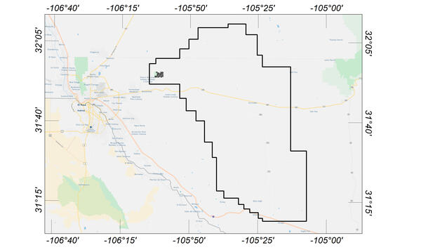
Flight area for Trans-Pecos aeromagnetic and radiometric survey
Flight area for Trans-Pecos aeromagnetic and radiometric surveyMap indicating flight area for Trans-Pecos aeromagnetic and radiometric survey. The survey area includes parts of El Paso and Hudspeth counties, Texas, and Otero County, New Mexico. Flights will begin in November 2020 and are expected to conclude in mid-January 2021.

Juvenile Cisco in a Holding Tank at HBBS
Juvenile cisco (Coregonus artedi) swim in a tank at Hammond Bay Biological Station. The station hosts multiple researchers conducting projects to aid restoration of Great Lakes cisco populations.
Juvenile cisco (Coregonus artedi) swim in a tank at Hammond Bay Biological Station. The station hosts multiple researchers conducting projects to aid restoration of Great Lakes cisco populations.

Sligo Creek Storm
Photo Contest Winner | January 2021 | Honorable Mention 2
Sligo Creek Storm
Photo Contest Winner | January 2021 | Honorable Mention 2
Sligo Creek Storm

Chiropterologist coloring page
This is a high resolution image for the whiteboard series Chiropterologist coloring page.
By
This is a high resolution image for the whiteboard series Chiropterologist coloring page.
By

Elkhorn coral at calcification assessment station in Dry Tortugas
Elkhorn coral at calcification assessment station in Dry TortugasEstablished in 2009, the U.S. Geological Survey’s Coral Assessment Network (USGS-CAN) provides data on coral-growth (calcification) rates throughout the Florida Keys. Pictured here is one of 30 stations located in in Dry Tortugas National Park.

Wind turbines in California
Wind turbines at the San Gorgonio Pass Wind Resource Area north of Palm Springs in California.
Wind turbines at the San Gorgonio Pass Wind Resource Area north of Palm Springs in California.

EO1 grouping of ALI scenes
Several different ALI images grouped together.
Several different ALI images grouped together.

Map of Waiʻōhinu area, Island of Hawaiʻi
Map of Waiʻōhinu area, Island of Hawaiʻi, showing the location of the 3,740 year old age.
Map of Waiʻōhinu area, Island of Hawaiʻi, showing the location of the 3,740 year old age.

Upper Southwest Rift Zone of Kīlauea Volcano—October 22, 2020
Upper Southwest Rift Zone of Kīlauea Volcano—October 22, 2020View looking southwest along the Southwest Rift Zone of Kīlauea Volcano. The unvegetated nature of the Southwest Rift Zone is on full display with the Keanakākoʻi Tephra in the foreground overlying lava flows from Cone Peak (the cone in the middle ground to the right).

Scientist holding brown treesnake
A USGS scientist holds an invasive brown treesnake.
A USGS scientist holds an invasive brown treesnake.