U.S. flag

An official website of the United States government

Images

Explore our planet through photography and imagery, including climate change and water all the way back to the 1800s when the USGS was surveying the country by horse and buggy.

Filter Total Items: 21394
Brian Bergamaschi, Katy O’Donnell, Emily Richardson, and Jeniffer Soto Perez onboard the RV Landsteiner
Brian Bergamaschi, Katy O’Donnell, Emily Richardson, and Jeniffer Soto

(From left to right) Brian Bergamaschi, Katy O’Donnell, Emily Richardson, and Jeniffer Soto Perez onboard the RV Landsteiner during a high-resolution water quality mapping survey.

(From left to right) Brian Bergamaschi, Katy O’Donnell, Emily Richardson, and Jeniffer Soto Perez onboard the RV Landsteiner during a high-resolution water quality mapping survey.

Photograph of USGS scientist collecting water samples in a marsh
Collecting Water Samples

USGS samples water within wetlands to understand which environmental drivers impact carbon cycle and sediment accretion. Here USGS staff (Jennifer O'Keefe Suttles) pumps water from at Phragmites wetland, Mashpee, MA, to analyze at the Woods Hole Coastal and Marine Science Center Environmental Geochemistry lab.

USGS samples water within wetlands to understand which environmental drivers impact carbon cycle and sediment accretion. Here USGS staff (Jennifer O'Keefe Suttles) pumps water from at Phragmites wetland, Mashpee, MA, to analyze at the Woods Hole Coastal and Marine Science Center Environmental Geochemistry lab.

Long, skinny Cuvier's Beaked Whale swimming just below the ocean surface, viewed from above
Cuvier’s Beaked Whale (Ziphius cavirostris)

Zoomed image of a Cuvier’s Beaked Whale (Ziphius cavirostris) below the surface.

Dave Brower (left) and Taylor Nagleri (right) working on logging data that was being collected by Rob Lorens in the stream
Dave Brower (left) and Taylor Nagleri (right) working on logging data

Dave Brower (left) and Taylor Nagleri (right) working on logging data that was being collected by Rob Lorens in the stream (not pictured).

Color photograph of lava lake crust
December 31, 2020—Kīlauea summit eruption

Kīlauea's summit lava lake in Halemaʻumaʻu is continually re-surfacing. HVO geologists monitoring the activity in the field have observed crustal foundering, in which pieces of solidified lava crust on the surface of the lava lake break and sink back into the liquid portion. USGS photo by M. Patrick on 12/31/2020. 

Kīlauea's summit lava lake in Halemaʻumaʻu is continually re-surfacing. HVO geologists monitoring the activity in the field have observed crustal foundering, in which pieces of solidified lava crust on the surface of the lava lake break and sink back into the liquid portion. USGS photo by M. Patrick on 12/31/2020. 

Color photograph of lava lake crust
December 31, 2020—Kīlauea summit eruption

The view from Kīlauea Volcano's western caldera rim shows the eastern portion of the lava lake in Halemaʻumaʻu crater. The main island is visible in the bottom of the photograph, and smaller islands can be seen above it (to the east). USGS photo by M. Patrick on 12/31/2020. 

The view from Kīlauea Volcano's western caldera rim shows the eastern portion of the lava lake in Halemaʻumaʻu crater. The main island is visible in the bottom of the photograph, and smaller islands can be seen above it (to the east). USGS photo by M. Patrick on 12/31/2020. 

Color photograph of lava lake crust
December 31, 2020—Kīlauea summit eruption

View of the northern portion of the lava lake within Halemaʻumaʻu crater at Kīlauea Volcano's summit. Smaller islands present in the northeastern portion of the lava lake are visible. USGS photo by M. Patrick on 12/31/2020. 

View of the northern portion of the lava lake within Halemaʻumaʻu crater at Kīlauea Volcano's summit. Smaller islands present in the northeastern portion of the lava lake are visible. USGS photo by M. Patrick on 12/31/2020. 

Color photograph of volcanic vent
December 31, 2020—Kīlauea summit eruption

The western fissure in Halemaʻumaʻu wall remains active. Glowing vents and a prominent spatter cone are visible in this photo. This view looks steeply down from Kīlauea's west caldera rim, and the lava lake surface is visible in the background. USGS photo by M. Patrick on 12/31/2020. 

The western fissure in Halemaʻumaʻu wall remains active. Glowing vents and a prominent spatter cone are visible in this photo. This view looks steeply down from Kīlauea's west caldera rim, and the lava lake surface is visible in the background. USGS photo by M. Patrick on 12/31/2020. 

Color photograph of lava lake crust
December 31, 2020—Kīlauea summit eruption

View of the northern portion of the lava lake within Halemaʻumaʻu crater at Kīlauea Volcano's summit. Smaller islands present in the northeastern portion of the lava lake are visible. USGS photo by M. Patrick on 12/31/2020. USGS photo by M. Patrick on 12/31/2020. 

View of the northern portion of the lava lake within Halemaʻumaʻu crater at Kīlauea Volcano's summit. Smaller islands present in the northeastern portion of the lava lake are visible. USGS photo by M. Patrick on 12/31/2020. USGS photo by M. Patrick on 12/31/2020. 

Color photograph of lava lake crust
December 31, 2020—Kīlauea summit eruption

Kīlauea's summit lava lake in Halemaʻumaʻu is continually re-surfacing. HVO geologists monitoring the activity in the field have observed crustal foundering, in which pieces of solidified lava crust on the surface of the lava lake break and sink back into the liquid portion. USGS photo by M. Patrick on 12/31/2020. 

Kīlauea's summit lava lake in Halemaʻumaʻu is continually re-surfacing. HVO geologists monitoring the activity in the field have observed crustal foundering, in which pieces of solidified lava crust on the surface of the lava lake break and sink back into the liquid portion. USGS photo by M. Patrick on 12/31/2020. 

Color photograph of lava lake crust
December 31, 2020—Kīlauea summit eruption

A channel-like feature is visible on the lava lake surface within Halemaʻumaʻu crater at Kīlauea Volcano's summit. This feature originates from the influx of lava from the western fissure, just out of view on the bottom of the photograph. USGS photo by M. Patrick on 12/31/2020. 

A channel-like feature is visible on the lava lake surface within Halemaʻumaʻu crater at Kīlauea Volcano's summit. This feature originates from the influx of lava from the western fissure, just out of view on the bottom of the photograph. USGS photo by M. Patrick on 12/31/2020. 

Color map of volcano
December 31, 2020—Kīlauea summit eruption contour map

This map of Halema‘uma‘u at the summit of Kīlauea shows 20 m (66 ft) contour lines (dark gray) that mark locations of equal elevation above sea level (asl).

This map of Halema‘uma‘u at the summit of Kīlauea shows 20 m (66 ft) contour lines (dark gray) that mark locations of equal elevation above sea level (asl).

Determining the height of a geyser eruption with trigonometry

Yellowstone rangers -- and tourists, too! -- can determine the height of a geyser eruption with some simple trigonometry.

Devin McGinty collecting measurements in the field

Devin McGinty collecting measurements in the field including surveying and installing a new staff gage. 

Fin whale just breaking the surface of the water, viewed from above
Fin Whale (Balaenoptera physalus) breaking the surface
Two images show the same cliff region, one has fewer data points by eliminating the frothy beach waves.
Fort Funston Structure-from-Motion point clouds

As part of the Remote Sensing of Coastal Change and Florence Supplemental projects we have been developing novel workflows for repeat-mapping of ­­­coastal environments at order decimeter resolution over up to hundreds of kilometers in a single day, using Structure-from-Motion photogrammetry or SfM, from crewed aerial platforms.

As part of the Remote Sensing of Coastal Change and Florence Supplemental projects we have been developing novel workflows for repeat-mapping of ­­­coastal environments at order decimeter resolution over up to hundreds of kilometers in a single day, using Structure-from-Motion photogrammetry or SfM, from crewed aerial platforms.

Geologic Map and Borehole Stratigraphy of Hinkley Valley and Vicinity, San Bernardino County, California
Geologic Map and Borehole Stratigraphy of Hinkley Valley and Vicinity,

Hinkley Valley, in the central to western Mojave Desert of southeastern California, has a long historical record owing to its position as a crossroads for rail and road traffic and its position adjacent to the Mojave River.

Hinkley Valley, in the central to western Mojave Desert of southeastern California, has a long historical record owing to its position as a crossroads for rail and road traffic and its position adjacent to the Mojave River.

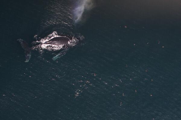
Humpback whale viewed from above, just breaking the surface, with seabirds in flight nearby
Humpback Whale and shearwaters feeding in southern California

Zoomed image of a Humpback Whale (Megaptera novaeangliae) and a group of shearwaters feeding in southern California.

Was this page helpful?