
Eagle Creek at Zionsville, IN downstream of gage
Images
Explore photos, graphics, and illustrations related to projects from across the CASC Network. And be sure to check out our Climate Illustrations page, featuring free-to-download illustrations that help describe tricky climate concepts and explain how climate change affects the world around us.
Filter Total Items: 639

Eagle Creek at Zionsville, IN downstream of gage

Arctic bluff erosion
USGS is studying climate change impacts to U.S. Pacific and Arctic coasts. Alaska’s north coast is predominantly erosional, retreating on average about 1.4 meters per year.
USGS is studying climate change impacts to U.S. Pacific and Arctic coasts. Alaska’s north coast is predominantly erosional, retreating on average about 1.4 meters per year.

Greater Yellowstone Area ice patches, northwestern Wyoming
Greater Yellowstone Area ice patches, northwestern WyomingGreater Yellowstone Area ice patches, northwestern Wyoming
Greater Yellowstone Area ice patches, northwestern Wyoming
Greater Yellowstone Area ice patches, northwestern WyomingGreater Yellowstone Area ice patches, northwestern Wyoming

NCASC Chief Doug Beard at IUCN Event
NCASC Chief Doug Beard presentingon sea level rise work at DOI CASCs at the US Pavilion at an IUCN event in Honolulu
NCASC Chief Doug Beard presentingon sea level rise work at DOI CASCs at the US Pavilion at an IUCN event in Honolulu

Franklin Mountains near the Hueco Bolson study area near El Paso, Tex.
Franklin Mountains near the Hueco Bolson study area near El Paso, Tex.Franklin Mountains near the Hueco Bolson study area near El Paso, Texas, September 2016. Photograph by Monica Langhorst, U.S. Geological Survey.
U.S. Geological Survey Scientific Investigations Report 2020–5056

Gulkana Glacier
Gulkana Glacier is located along the south flank of the eastern Alaska Range.
Gulkana Glacier is located along the south flank of the eastern Alaska Range.

The majestic Brooks Range in Gates of the Arctic National Park, Alaska
The majestic Brooks Range in Gates of the Arctic National Park, AlaskaThe majestic Brooks Range in Gates of the Arctic National Park, Alaska. This work is part of the Hydro-Ecology of Arctic Thawing (HEAT): Hydrology project that takes place in the Arctic Network Parks.

Established pollinator plot at Northern Prairie Wildlife Research Center.
Established pollinator plot at Northern Prairie Wildlife Research Center.Prairie coneflower, Blanket flower, and Phacelia bloom in an established Pollinator Plot at Northern Prairie Wildlife Research Center, Jamestown, North Dakota.

Rocky Mountain sunset
This is a sunset on the Front Range of Colorado in summer.
This is a sunset on the Front Range of Colorado in summer.

A Restored Wetland
Landscape view of a hydrologically restored wetland unit within the Ottawa National Wildlife Refuge, OH, USA. Photo Credit: Kurt Kowalski, USGS.
Landscape view of a hydrologically restored wetland unit within the Ottawa National Wildlife Refuge, OH, USA. Photo Credit: Kurt Kowalski, USGS.
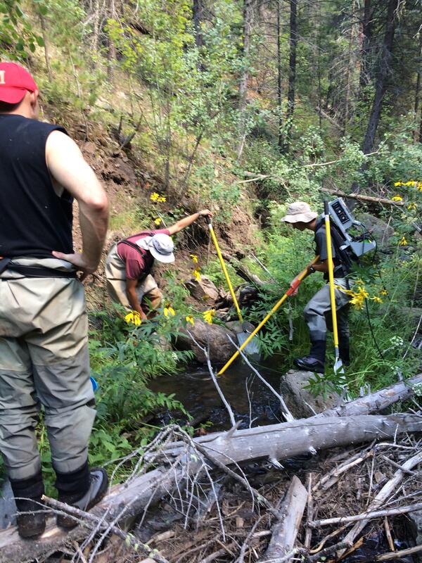
Electrofishing in a New Mexico Stream
Increasing temperatures and decreasing precipitation threaten the persistence of the Rio Grande cutthroat trout, the southernmost subspecies of cutthroat trout, found only in parts of New Mexico and Colorado.
Increasing temperatures and decreasing precipitation threaten the persistence of the Rio Grande cutthroat trout, the southernmost subspecies of cutthroat trout, found only in parts of New Mexico and Colorado.
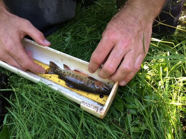
Measuring a Rio Grande Cutthroat Trout
Increasing temperatures and decreasing precipitation threaten the persistence of the Rio Grande cutthroat trout, the southernmost subspecies of cutthroat trout, found only in parts of New Mexico and Colorado.
Increasing temperatures and decreasing precipitation threaten the persistence of the Rio Grande cutthroat trout, the southernmost subspecies of cutthroat trout, found only in parts of New Mexico and Colorado.

Setting Drift Net to Catch Fish in Stream
Increasing temperatures and decreasing precipitation threaten the persistence of the Rio Grande cutthroat trout, the southernmost subspecies of cutthroat trout, found only in parts of New Mexico and Colorado.
Increasing temperatures and decreasing precipitation threaten the persistence of the Rio Grande cutthroat trout, the southernmost subspecies of cutthroat trout, found only in parts of New Mexico and Colorado.

Abby Lynch Holding Rio Grand Cutthroat Trout
Increasing temperatures and decreasing precipitation threaten the persistence of the Rio Grande cutthroat trout, the southernmost subspecies of cutthroat trout, found only in parts of New Mexico and Colorado.
Increasing temperatures and decreasing precipitation threaten the persistence of the Rio Grande cutthroat trout, the southernmost subspecies of cutthroat trout, found only in parts of New Mexico and Colorado.

Abby Lynch Scientist Spotlight
Capitol Hill lawmakers requested an informational briefing on the documented impacts of climate change on inland fish and fisheries.
Capitol Hill lawmakers requested an informational briefing on the documented impacts of climate change on inland fish and fisheries.

Spruce Grouse, Mt. Washington, White Mountain National Forest, NH
Spruce Grouse, Mt. Washington, White Mountain National Forest, NHSpruce grouse on Mt. Washington, White Mountain National Forest, NH
Spruce Grouse, Mt. Washington, White Mountain National Forest, NH
Spruce Grouse, Mt. Washington, White Mountain National Forest, NHSpruce grouse on Mt. Washington, White Mountain National Forest, NH
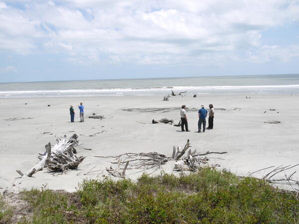
Scientists and Managers Meet on a Southeastern Beach
Scientists and Managers Meet on a Southeastern BeachThe Southeast Climate Science Center is partnering with National Wildlife Refuges along the east coast to understand climate change impacts to important natural resources.
Scientists and Managers Meet on a Southeastern Beach
Scientists and Managers Meet on a Southeastern BeachThe Southeast Climate Science Center is partnering with National Wildlife Refuges along the east coast to understand climate change impacts to important natural resources.

Grizzly Bear and Cub in Yellowstone National Park
Female grizzly bear with her young cub near the Gibbon River in Yellowstone National Park. Photo was taken in April 2016 by USGS scientist Frank van Manen.
Female grizzly bear with her young cub near the Gibbon River in Yellowstone National Park. Photo was taken in April 2016 by USGS scientist Frank van Manen.

American pika eating plants.
American pika eating plants.

Measuring suspended sediment in San Francisco Bay
USGS researchers collect water samples from the Research Vessel Dorah Henry to measure suspended sediment concentration in Central San Francisco Bay. Samples were collected using a D-96 sampler that collects samples over the entire depth of the water column allowing for a depth-integrated sample.
USGS researchers collect water samples from the Research Vessel Dorah Henry to measure suspended sediment concentration in Central San Francisco Bay. Samples were collected using a D-96 sampler that collects samples over the entire depth of the water column allowing for a depth-integrated sample.

Field Work on Mount Rainier
Researcher Amanda Kissel pauses by a lake in Mt. Rainier National Park.
Researcher Amanda Kissel pauses by a lake in Mt. Rainier National Park.