USGS Geologist approaches an old exploration trench
USGS Geologist approaches an old exploration trenchGeologist George Case approaches an old exploration trench exposing stratiform Ag-Sn-Pb-Zn mineralization in the Groundhog Basin deposit area.

Official websites use .gov
A .gov website belongs to an official government organization in the United States.
Secure .gov websites use HTTPS
A lock () or https:// means you’ve safely connected to the .gov website. Share sensitive information only on official, secure websites.
Explore photos, graphics, and illustrations related to projects from across the CASC Network. And be sure to check out our Climate Illustrations page, featuring free-to-download illustrations that help describe tricky climate concepts and explain how climate change affects the world around us.

Geologist George Case approaches an old exploration trench exposing stratiform Ag-Sn-Pb-Zn mineralization in the Groundhog Basin deposit area.
Geologist George Case approaches an old exploration trench exposing stratiform Ag-Sn-Pb-Zn mineralization in the Groundhog Basin deposit area.

A vegetated drainageway wetland on Bureau of Land Management land near Rawlins, WY
A vegetated drainageway wetland on Bureau of Land Management land near Rawlins, WY
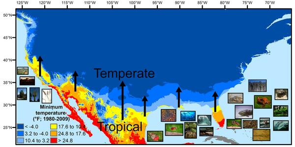
A map showing North America's tropical-to-temperate transition zone. Red, orange, and yellow depict the more tropical zones, and blues depict the more temperate zones, based on to the coldest recorded temperature for each area between 1980 and 2009.
A map showing North America's tropical-to-temperate transition zone. Red, orange, and yellow depict the more tropical zones, and blues depict the more temperate zones, based on to the coldest recorded temperature for each area between 1980 and 2009.
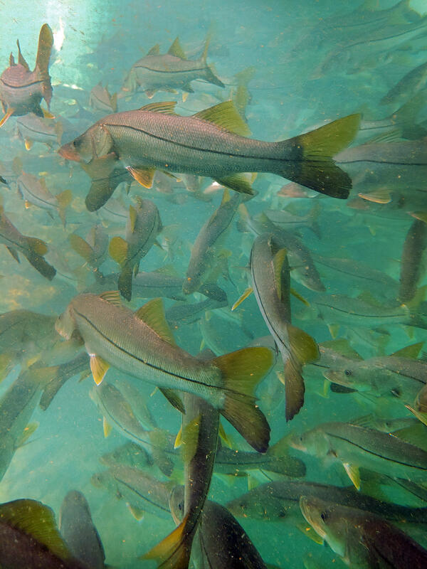
Winter temperature extremes control the distributions of subtropical fishes. Common snook (Centropomus undecimalis), aggregate at a spring in northern Florida during winter. Snook are warm saltwater game fish, common in Florida, that have been moving further northward as extreme cold spells become less frequent and less intense.
Winter temperature extremes control the distributions of subtropical fishes. Common snook (Centropomus undecimalis), aggregate at a spring in northern Florida during winter. Snook are warm saltwater game fish, common in Florida, that have been moving further northward as extreme cold spells become less frequent and less intense.

A concrete-lined stretch of the Los Angeles River that runs near Sepulveda Dam. USGS streamgage 11092450 can be seen in the lower left along the river wall. Restoration is planned for this stretch of the river that runs through the San Fernando Valley.
A concrete-lined stretch of the Los Angeles River that runs near Sepulveda Dam. USGS streamgage 11092450 can be seen in the lower left along the river wall. Restoration is planned for this stretch of the river that runs through the San Fernando Valley.

An aerial view of Margerie Glacier. Glaciers are important for many species found in Glacier Bay National Park and Preserve. NPS.
An aerial view of Margerie Glacier. Glaciers are important for many species found in Glacier Bay National Park and Preserve. NPS.

Golden eagle populations in North America are either holding steady or possibly in decline and below the number that which the environment can support.
Golden eagle populations in North America are either holding steady or possibly in decline and below the number that which the environment can support.

An aerial view of the upper cracks in the Wolverine Glacier icefall as sunset approaches.
An aerial view of the upper cracks in the Wolverine Glacier icefall as sunset approaches.

Looking upstream on the San Miguel River in Colorado in fall 2020 when baseflow (groundwater flowing to streams) is the primary contributor to streamflow.
Looking upstream on the San Miguel River in Colorado in fall 2020 when baseflow (groundwater flowing to streams) is the primary contributor to streamflow.

Unuk River waterfalls from old lava pipes. Volcanic lava pipes form as the result of violent eruptions of deep-origin volcanoes. The Unuk River is one of the transboundary watersheds of Southeast Alaska.
Unuk River waterfalls from old lava pipes. Volcanic lava pipes form as the result of violent eruptions of deep-origin volcanoes. The Unuk River is one of the transboundary watersheds of Southeast Alaska.

Devin Gaige and Amanda May measure bathymetry of the Black River near Great Bend, NY
Devin Gaige and Amanda May measure bathymetry of the Black River near Great Bend, NY

The USGS Great Lakes Science Center’s Sea Ark at sunrise as the crew prepares to tend acoustic telemetry receivers around Isle Royale National Park in Lake Superior; the receivers monitor movement of tagged native lake trout in the area.
The USGS Great Lakes Science Center’s Sea Ark at sunrise as the crew prepares to tend acoustic telemetry receivers around Isle Royale National Park in Lake Superior; the receivers monitor movement of tagged native lake trout in the area.

Quinebaug River near West Thompson, Connecticut. Photo shows one of few deeper pools of water in the 01124151 station vicinity during drought.
Quinebaug River near West Thompson, Connecticut. Photo shows one of few deeper pools of water in the 01124151 station vicinity during drought.

Rim Fire in Yosemite National Park.

Photo of mountains from Crested Butte, CO.
Photo of mountains from Crested Butte, CO.

USGS gage 422302071083801 Fresh Pond in Gate House at Cambridge, Massachusetts.
USGS gage 422302071083801 Fresh Pond in Gate House at Cambridge, Massachusetts.

Upstream view of the Middle Fork Fortymile River near U.S. Geological Survey streamgage 15331000, Middle Fork Fortymile River near mouth near Chicken, Alaska
Upstream view of the Middle Fork Fortymile River near U.S. Geological Survey streamgage 15331000, Middle Fork Fortymile River near mouth near Chicken, Alaska

: A site visit to Puerto Rico’s Sierra de Luquillo mountains and El Yunque National Forest, 2020. (credit – M. Eaton)
: A site visit to Puerto Rico’s Sierra de Luquillo mountains and El Yunque National Forest, 2020. (credit – M. Eaton)

The whistling coqui (E. cochranae), one of 17 iconic Puerto Rican amphibians in the genus Eleutherodactylus, observed in a lowland delta marsh of the Arecibo River on Puerto Rico’s north coast. (credit – M. Eaton)
The whistling coqui (E. cochranae), one of 17 iconic Puerto Rican amphibians in the genus Eleutherodactylus, observed in a lowland delta marsh of the Arecibo River on Puerto Rico’s north coast. (credit – M. Eaton)

Laurel Creek Cave behind Laurel Falls, Laurel-Snow State Natural Area, Tennessee
Laurel Creek Cave behind Laurel Falls, Laurel-Snow State Natural Area, Tennessee
