



Members of the PCMSC Marine Minerals Team, including physical science technician Kira Mizell (center), took turns describing the importance of seafloor minerals.
Images
Coastal and Marine Hazards and Resources Program images.
Filter Total Items: 2491

USGS Open House discussions
Members of the PCMSC Marine Minerals Team, including physical science technician Kira Mizell (center), took turns describing the importance of seafloor minerals.

Talking about seafloor mineral deposits
Research geologist Jim Hein (right) gave a hands-on explanation of seafloor mineral deposits.
Research geologist Jim Hein (right) gave a hands-on explanation of seafloor mineral deposits.

Upper terrace of Mud Creek slide
Mud Creek slide from south side of north upper terrace (above north and south berms). Note tension cracks and offset on the terrace to the north.
Mud Creek slide from south side of north upper terrace (above north and south berms). Note tension cracks and offset on the terrace to the north.

Field survey methods
Photos of survey equipment used during surveys of the Elwha River delta, Washington, from 2010-2017, showing:
Photos of survey equipment used during surveys of the Elwha River delta, Washington, from 2010-2017, showing:

Flooding on a road in Olympic National Park, Washington
Flooding on a road in Olympic National Park, WashingtonFlooding on a road in Olympic National Park, Washington, on November 24, 2017.
Flooding on a road in Olympic National Park, Washington
Flooding on a road in Olympic National Park, WashingtonFlooding on a road in Olympic National Park, Washington, on November 24, 2017.

Cross sections of Arctica islandica embedded in epoxy
Cross sections of Arctica islandica embedded in epoxyArctica islandica shells have been sectioned with a saw and embedded in epoxy for further analysis.
Cross sections of Arctica islandica embedded in epoxy
Cross sections of Arctica islandica embedded in epoxyArctica islandica shells have been sectioned with a saw and embedded in epoxy for further analysis.

Santa Cruz Main Beach Webcam Snapshot
Snapshot from video camera that sits atop the Dream Inn looks eastward over Main Beach and boardwalk in Santa Cruz, California.
Snapshot from video camera that sits atop the Dream Inn looks eastward over Main Beach and boardwalk in Santa Cruz, California.

Santa Cruz Main Beach
Still-image from video camera atop the Dream Inn looks eastward over Main Beach and boardwalk in Santa Cruz, CA.
Still-image from video camera atop the Dream Inn looks eastward over Main Beach and boardwalk in Santa Cruz, CA.
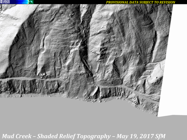
Mud Creek Shaded-Relief Topography, 2010-2017
A series of images from various sources of shaded-relief topography show the progression of the Mud Creek landslide area, from 2010 through October 12, 2017.
Sources:
A series of images from various sources of shaded-relief topography show the progression of the Mud Creek landslide area, from 2010 through October 12, 2017.
Sources:

SeaBOSS on the fantail of the R/V Connecticut on Long Island Sound
SeaBOSS on the fantail of the R/V Connecticut on Long Island SoundSeaBOSS on the fantail of the R/V Connecticut on Long Island Sound at sunrise
SeaBOSS on the fantail of the R/V Connecticut on Long Island Sound
SeaBOSS on the fantail of the R/V Connecticut on Long Island SoundSeaBOSS on the fantail of the R/V Connecticut on Long Island Sound at sunrise

USGS personnel adjusting equipment on the SeaBOSS
USGS personnel adjust equipment on the SeaBOSS on the fantail of the R/V Connecticut on Long Island Sound
USGS personnel adjust equipment on the SeaBOSS on the fantail of the R/V Connecticut on Long Island Sound

SeaBOSS Survey on Long Island Sound
Image of the SeaBOSS and USGS personnel on the fantail of the R/V Connecticut in Long Island Sound
Image of the SeaBOSS and USGS personnel on the fantail of the R/V Connecticut in Long Island Sound

Feeling crabby
Seafloor photograph of a spider crab, sediment, rocks, taken by the Woods Hole Coastal and Marine Science Center SeaBOSS during a deployment off the R/V Connecticut in Long Island Sound
Seafloor photograph of a spider crab, sediment, rocks, taken by the Woods Hole Coastal and Marine Science Center SeaBOSS during a deployment off the R/V Connecticut in Long Island Sound

SeaBOSS on the fantail of the R/V Connecticut on Long Island Sound
SeaBOSS on the fantail of the R/V Connecticut on Long Island SoundSeaBOSS on the fantail of R/V Connecticut on Long Island Sound
SeaBOSS on the fantail of the R/V Connecticut on Long Island Sound
SeaBOSS on the fantail of the R/V Connecticut on Long Island SoundSeaBOSS on the fantail of R/V Connecticut on Long Island Sound

Long Island Sound Survey Team
Long Island Sound Survey mapping team. This project is a collaboration of several agencies and institutions including Univ of Connecticut, Univ of New Haven, Connecticut Department of Energy and Environmental Protection, NOAA, LDEO, USGS
Long Island Sound Survey mapping team. This project is a collaboration of several agencies and institutions including Univ of Connecticut, Univ of New Haven, Connecticut Department of Energy and Environmental Protection, NOAA, LDEO, USGS

Storm overwash, Surf Drive Beach, Falmouth, MA
Storm overwash, Surf Drive Beach, Falmouth, MA
Storm overwash, Surf Drive Beach, Falmouth, MA

Storm overwash, Surf Drive Beach, Falmouth, MA
Storm overwash, Surf Drive Beach, Falmouth, MA
Storm overwash, Surf Drive Beach, Falmouth, MA

Surf Drive Beach, Falmouth, MA
Overwash from Surf Drive Beach, Falmouth, MA

Storm overwash, Surf Drive Beach, Falmouth MA
Storm overwash on Surf Drive Beach, Falmouth, MA
Storm overwash on Surf Drive Beach, Falmouth, MA

Mud Creek Topo Change June 13-October 12 2017 View 1
Mud Creek Topo Change June 13-October 12 2017 View 1In 2017, the massive Mud Creek landslide buried a quarter-mile of the famous coastal route, California’s Highway 1, with rocks and dirt more than 65 feet deep. USGS monitors erosion along the landslide-prone cliffs of Big Sur, collecting aerial photos frequently throughout the year.
Mud Creek Topo Change June 13-October 12 2017 View 1
Mud Creek Topo Change June 13-October 12 2017 View 1In 2017, the massive Mud Creek landslide buried a quarter-mile of the famous coastal route, California’s Highway 1, with rocks and dirt more than 65 feet deep. USGS monitors erosion along the landslide-prone cliffs of Big Sur, collecting aerial photos frequently throughout the year.

Mud Creek Topo Change June 13-October 12 2017 View 2
Mud Creek Topo Change June 13-October 12 2017 View 2In 2017, the massive Mud Creek landslide buried a quarter-mile of the famous coastal route, California’s Highway 1, with rocks and dirt more than 65 feet deep. USGS monitors erosion along the landslide-prone cliffs of Big Sur, collecting aerial photos frequently throughout the year.
Mud Creek Topo Change June 13-October 12 2017 View 2
Mud Creek Topo Change June 13-October 12 2017 View 2In 2017, the massive Mud Creek landslide buried a quarter-mile of the famous coastal route, California’s Highway 1, with rocks and dirt more than 65 feet deep. USGS monitors erosion along the landslide-prone cliffs of Big Sur, collecting aerial photos frequently throughout the year.