



Nukuhou coastal wetland. A tidal wetland with grey mangroves (Avicennia marina) and salt marsh threatened by sea level rise. At Ohiwa Harbor, North Island, New Zealand.
Images
Explore images taken during Ecosystems' Land Change Science Program fieldwork and research.
Filter Total Items: 209

New Zealand coastal wetland
Nukuhou coastal wetland. A tidal wetland with grey mangroves (Avicennia marina) and salt marsh threatened by sea level rise. At Ohiwa Harbor, North Island, New Zealand.

Sunrise in Santa Cruz, CA
Sunrise along the coast of the Pacific Ocean in Santa Cruz, California. Credit: Ariana Sutton-Grier, USGS.
Sunrise along the coast of the Pacific Ocean in Santa Cruz, California. Credit: Ariana Sutton-Grier, USGS.

Rangaunu Harbour in Northland, New Zealand.
Aerial view of the Rangaunu Harbour mangrove forest in Northland, New Zealand.
Aerial view of the Rangaunu Harbour mangrove forest in Northland, New Zealand.

Omaha-Taniko Scientific Preserve, New Zealand
Omaha-Taniko Scientific Preserve. An extensive saltmarsh area in the Whangateau Harbour that has a rare intact vegetation sequence from mangrove forest and scrub ecosystem to saltmarsh to the Mānuka-dominated scrub wetland to Kahikatea swamp forest.
Omaha-Taniko Scientific Preserve. An extensive saltmarsh area in the Whangateau Harbour that has a rare intact vegetation sequence from mangrove forest and scrub ecosystem to saltmarsh to the Mānuka-dominated scrub wetland to Kahikatea swamp forest.

Shrub Mangrove Forest in Rangaunu Harbour, New Zealand
Shrub Mangrove Forest in Rangaunu Harbour, New ZealandAerial view of shrub mangrove forest in Rangaunu Harbour expanding into coast salt marsh and threatening to move into agricultural land because of sea level rise.
Shrub Mangrove Forest in Rangaunu Harbour, New Zealand
Shrub Mangrove Forest in Rangaunu Harbour, New ZealandAerial view of shrub mangrove forest in Rangaunu Harbour expanding into coast salt marsh and threatening to move into agricultural land because of sea level rise.

Sangre de Cristo Mountains fieldwork
Research Geologist Natalie Kehrwald cuts a “cookie” from a fire-scarred tree in the southern Sangre de Cristo Mountains, New Mexico. Cookies are cross-sections of trees that provide information on the interactions between past droughts and fires.
Research Geologist Natalie Kehrwald cuts a “cookie” from a fire-scarred tree in the southern Sangre de Cristo Mountains, New Mexico. Cookies are cross-sections of trees that provide information on the interactions between past droughts and fires.

Sampling Soil 1-year after the 2021 Dixie Fire
Two USGS scientists preparing to collect soils and measuring infiltration to quantify microbial, biogeochemical, and hydrological recovery 1 year after the 2021 Dixie Fire. They have been seasonally measuring soil recovery at 11 sites within the footprint of the Dixie Fire.
Two USGS scientists preparing to collect soils and measuring infiltration to quantify microbial, biogeochemical, and hydrological recovery 1 year after the 2021 Dixie Fire. They have been seasonally measuring soil recovery at 11 sites within the footprint of the Dixie Fire.

Dead Giant Sequoia in the Board Camp grove, Sequoia National Park
Dead Giant Sequoia in the Board Camp grove, Sequoia National ParkField technician sizes up a monarch giant sequoia killed in the 2020 KNP-Complex/Castle fire (Board Camp grove, Sequoia National Park.) Unfortunately, the vast majority of giant sequoia within the grove were killed during the catastrophic 2020 Castle fire. Credit: USGS Sequoia Research Program, image provided by David Soderberg (USGS Biologist)
Dead Giant Sequoia in the Board Camp grove, Sequoia National Park
Dead Giant Sequoia in the Board Camp grove, Sequoia National ParkField technician sizes up a monarch giant sequoia killed in the 2020 KNP-Complex/Castle fire (Board Camp grove, Sequoia National Park.) Unfortunately, the vast majority of giant sequoia within the grove were killed during the catastrophic 2020 Castle fire. Credit: USGS Sequoia Research Program, image provided by David Soderberg (USGS Biologist)

Confluence of Green and Yampa Rivers
Confluence of the Green and Yampa Rivers (green color is the Green and yellow color is the Yampa). The color of the water is an indication of the very different streamflow patterns between the two rivers. Credit: Becky Brice, USGS
Confluence of the Green and Yampa Rivers (green color is the Green and yellow color is the Yampa). The color of the water is an indication of the very different streamflow patterns between the two rivers. Credit: Becky Brice, USGS

Retrieving a sediment trap on the R/V Weatherbird II
Retrieving a sediment trap on the R/V Weatherbird IICaitlin Reynolds retrieving one of the sediment traps used by USGS to study sediment flux in the Gulf of America on board the Research Vessel (R/V) Weatherbird II (Florida Institute of Oceanography).
Retrieving a sediment trap on the R/V Weatherbird II
Retrieving a sediment trap on the R/V Weatherbird IICaitlin Reynolds retrieving one of the sediment traps used by USGS to study sediment flux in the Gulf of America on board the Research Vessel (R/V) Weatherbird II (Florida Institute of Oceanography).

Taking water samples from a CTD-rosette
Eckerd College students taking water samples from a CTD-rosette on board the R/V Weatherbird
Eckerd College students taking water samples from a CTD-rosette on board the R/V Weatherbird

R/V Weatherbird II in port
The R/V Weatherbird II docked at the Florida Institute of Oceanography at University of South Florida (USF) College of Marine Science in St. Petersburg, Florida. USGS scientists and partners at Eckerd College and USF load the vessel in preparation for a research cruise as part of a National Science Foundation (NSF)-funded Scientists-at-Sea program.
The R/V Weatherbird II docked at the Florida Institute of Oceanography at University of South Florida (USF) College of Marine Science in St. Petersburg, Florida. USGS scientists and partners at Eckerd College and USF load the vessel in preparation for a research cruise as part of a National Science Foundation (NSF)-funded Scientists-at-Sea program.
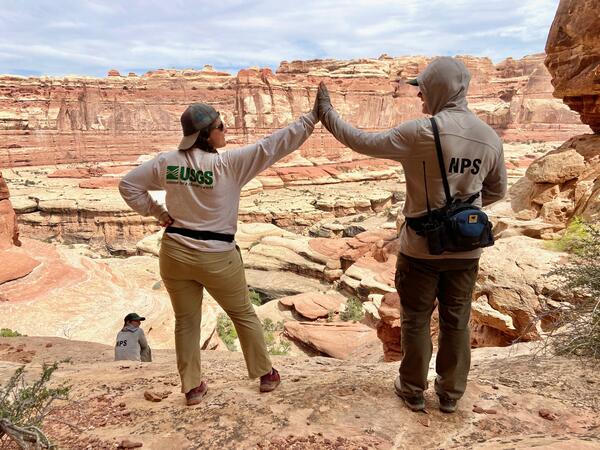
Canyonlands National Park
A 30-year partnership between the USGS and National Park Service shows how the drylands of Canyonlands National Park are responding to a hotter, drier future.
A 30-year partnership between the USGS and National Park Service shows how the drylands of Canyonlands National Park are responding to a hotter, drier future.

Giant Sequoias after the KNP Complex Fire
Mature giant sequoia survivorship with mottled, fire-caused understory mortality within mixed severity fire in Muir Grove, Sequoia National Park. 'Backburn' management operations were conducted to reduce fire severity before the leading edge of the KNP Complex wildfire moved into Muir Grove, reducing the likelihood of more severe fire effects.
Mature giant sequoia survivorship with mottled, fire-caused understory mortality within mixed severity fire in Muir Grove, Sequoia National Park. 'Backburn' management operations were conducted to reduce fire severity before the leading edge of the KNP Complex wildfire moved into Muir Grove, reducing the likelihood of more severe fire effects.

Planktic Foraminifera from Southern Maryland
Ten species of planktic foraminifera from PETM sediments in southern Maryland. The scale bars measure 150 microns (0.015 cm). Each specimen is similar in size to a grain of sand.
Ten species of planktic foraminifera from PETM sediments in southern Maryland. The scale bars measure 150 microns (0.015 cm). Each specimen is similar in size to a grain of sand.

Isotopic Water Analyzer
This Picarro L2130-i Isotope and Gas Concentration Analyzer is housed at the USGS St. Petersburg Coastal and Marine Science Center.
This Picarro L2130-i Isotope and Gas Concentration Analyzer is housed at the USGS St. Petersburg Coastal and Marine Science Center.

Wildcat Lake, California
Paleoecologists Marie Champagne, Lysanna Anderson, and Clarke Knight work to obtain lake sediment cores from Wildcat Lake, a coastal site in Point Reyes National Seashore, California, in November 2021. (Photo Credit: Summer Praetorius, USGS)
Paleoecologists Marie Champagne, Lysanna Anderson, and Clarke Knight work to obtain lake sediment cores from Wildcat Lake, a coastal site in Point Reyes National Seashore, California, in November 2021. (Photo Credit: Summer Praetorius, USGS)

Sediment Cores from Wildcat Lake, California
After many days of coring, eight meters of lake sediment were obtained from Wildcat Lake by a group of scientists including Clarke Knight and Marie Champagne (left to right). (Photo Credit: Lysanna Anderson)
After many days of coring, eight meters of lake sediment were obtained from Wildcat Lake by a group of scientists including Clarke Knight and Marie Champagne (left to right). (Photo Credit: Lysanna Anderson)

Soil Monitoring Site in Burnt Chaparral Ecosystem
An established monitoring site to assess soil recovery in a chaparral ecosystem that burned in the 2020 LNU Lightning Complex Fire.
An established monitoring site to assess soil recovery in a chaparral ecosystem that burned in the 2020 LNU Lightning Complex Fire.

Lemon Creek Glacier
Two USGS scientists walk across the surface of Lemon Creek Glacier near the end of the melt season surrounded by green hills and barren rock.
Two USGS scientists walk across the surface of Lemon Creek Glacier near the end of the melt season surrounded by green hills and barren rock.

Lemon Creek Glacier
Researchers walk amid the glacial ice and crevasses left bare by summer melt on Lemon Creek Glacier, AK.
Researchers walk amid the glacial ice and crevasses left bare by summer melt on Lemon Creek Glacier, AK.