



Miriam Jones holding a peat core that was extracted from a thawed permafrost bog at the Alaska Permafrost Experiment (APEX) site at Bonanza Creek LTER, Alaska. The boundary between the formerly frozen permafrost plateau and thawed bog is visible in the peat stratigraphy, with the light-colored peat indicated thawed bog.
Images
Explore images taken during Ecosystems' Land Change Science Program fieldwork and research.
Filter Total Items: 209

Miriam Jones holds a peat core in Alaska
Miriam Jones holding a peat core that was extracted from a thawed permafrost bog at the Alaska Permafrost Experiment (APEX) site at Bonanza Creek LTER, Alaska. The boundary between the formerly frozen permafrost plateau and thawed bog is visible in the peat stratigraphy, with the light-colored peat indicated thawed bog.

Map of AK showing probability of change occurrence
Map of AK showing probability of change occurrenceMap of Alaska showing probability (%) of change occurrence. Insets show fire boundaries from the Bureau of Land Management (BLM) Large Fire Database and Landsat 8 imagery (bottom right; 2016) north of Fairbanks, Alaska.
Map of AK showing probability of change occurrence
Map of AK showing probability of change occurrenceMap of Alaska showing probability (%) of change occurrence. Insets show fire boundaries from the Bureau of Land Management (BLM) Large Fire Database and Landsat 8 imagery (bottom right; 2016) north of Fairbanks, Alaska.

Tipping trees on top of permafrost in Innoko National Wildlife Refuge, AK
Tipping trees on top of permafrost in Innoko National Wildlife Refuge, AKCaption: Trees tipping over and dying as ice-rich permafrost thaws in the Innoko National Wildlife Refuge, Alaska.
Tipping trees on top of permafrost in Innoko National Wildlife Refuge, AK
Tipping trees on top of permafrost in Innoko National Wildlife Refuge, AKCaption: Trees tipping over and dying as ice-rich permafrost thaws in the Innoko National Wildlife Refuge, Alaska.

Douglas-fir Forest in the Klamath Bioregion of California
Douglas-fir Forest in the Klamath Bioregion of CaliforniaDense stands of Douglas-fir surround South Twin Lake in the Klamath bioregion of northwestern California.
Douglas-fir Forest in the Klamath Bioregion of California
Douglas-fir Forest in the Klamath Bioregion of CaliforniaDense stands of Douglas-fir surround South Twin Lake in the Klamath bioregion of northwestern California.
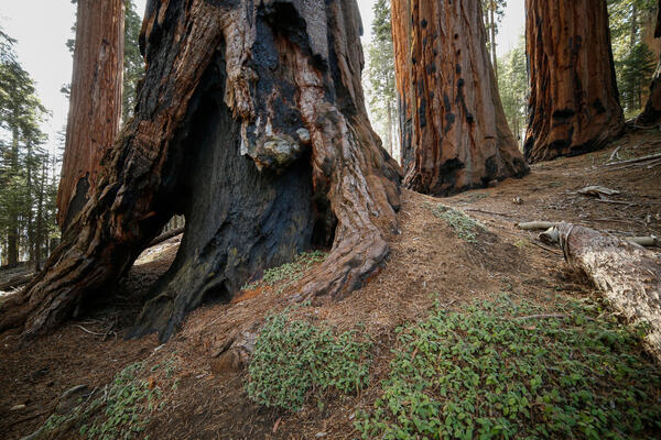
Burned, hollowed out base of a sequoia tree in Sequoia National Park
Burned, hollowed out base of a sequoia tree in Sequoia National ParkBurned, hollowed out base of a sequoia tree in Sequoia National Park
Burned, hollowed out base of a sequoia tree in Sequoia National Park
Burned, hollowed out base of a sequoia tree in Sequoia National ParkBurned, hollowed out base of a sequoia tree in Sequoia National Park

Geologists Sampling at Scientists Cliffs
Photo shows USGS geologists obtaining microfossil and biomarker samples from the Calvert Formation at Scientists Cliffs.
Photo shows USGS geologists obtaining microfossil and biomarker samples from the Calvert Formation at Scientists Cliffs.

Coring snow
A scientist prepares to extract a snow core from one of the Benchmark Glaciers. Cores are used to determine the density of the snow and ice on the surface of the glacier in order to determine the mass balance.
A scientist prepares to extract a snow core from one of the Benchmark Glaciers. Cores are used to determine the density of the snow and ice on the surface of the glacier in order to determine the mass balance.

Ice core extracted from Wolverine Glacier, Alaska
USGS scientist, Chris McNeil, measures and weighs an ice core extracted from Wolverine Glacier to determine the density of the firn layer.
USGS scientist, Chris McNeil, measures and weighs an ice core extracted from Wolverine Glacier to determine the density of the firn layer.

Testing Drone Technology
A USGS scientist testing drone technology to measure methane fluxes from thawing permafrost.
A USGS scientist testing drone technology to measure methane fluxes from thawing permafrost.
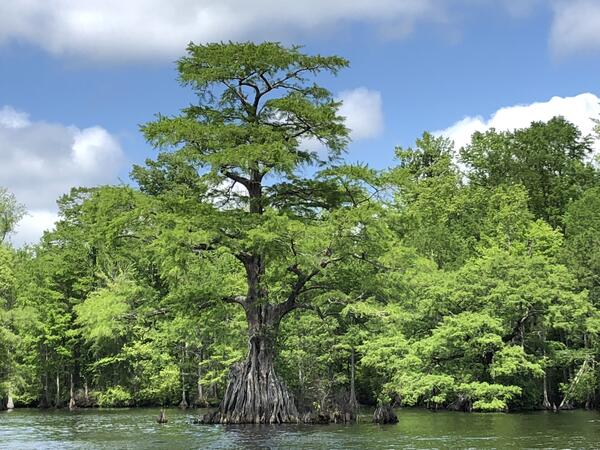
Cyprus Tree, Great Dismal Swamp, Lake Drummond, Virginia
Cyprus Tree, Great Dismal Swamp, Lake Drummond, VirginiaA cyprus tree in Lake Drummond, Great Dismal Swamp National Wildlife Refuge, Virginia
Cyprus Tree, Great Dismal Swamp, Lake Drummond, Virginia
Cyprus Tree, Great Dismal Swamp, Lake Drummond, VirginiaA cyprus tree in Lake Drummond, Great Dismal Swamp National Wildlife Refuge, Virginia

Coastal Marsh at Aransas National Wildlife Refuge, Texas
Coastal Marsh at Aransas National Wildlife Refuge, TexasA coastal marsh site at Aransas National Wildlife Refuge near St. Charles Bay, Texas. A surface elevation table-marker horizon (SET-MH) station is hidden beneath the marsh vegetation. The SET-MH is used to record changes in marsh surface elevation through time. Taken by William C. Vervaeke, 4/5/2018 (USGS).
Coastal Marsh at Aransas National Wildlife Refuge, Texas
Coastal Marsh at Aransas National Wildlife Refuge, TexasA coastal marsh site at Aransas National Wildlife Refuge near St. Charles Bay, Texas. A surface elevation table-marker horizon (SET-MH) station is hidden beneath the marsh vegetation. The SET-MH is used to record changes in marsh surface elevation through time. Taken by William C. Vervaeke, 4/5/2018 (USGS).

Aseptic Sampling of a Permafrost Core
A scientist wearing a mask, safety googles, and a cap breaks down a permafrost core using a paring knife to conduct aseptic sampling for DNA analysis.
A scientist wearing a mask, safety googles, and a cap breaks down a permafrost core using a paring knife to conduct aseptic sampling for DNA analysis.

Scientist Conducting Soil Carbon Experiments
Injecting 13C enriched carbon into soil incubations to quantify organo-mineral association of dead microbes with soil minerals.
Injecting 13C enriched carbon into soil incubations to quantify organo-mineral association of dead microbes with soil minerals.

Rainbow Glacier perimeter: 1966, 1998, 2005, 2015.
Rainbow Glacier perimeter: 1966, 1998, 2005, 2015.This image shows the perimeter of Rainbow Glacier in Glacier National Park: 1966, 1998, 2005, 2015.
Rainbow Glacier perimeter: 1966, 1998, 2005, 2015.
Rainbow Glacier perimeter: 1966, 1998, 2005, 2015.This image shows the perimeter of Rainbow Glacier in Glacier National Park: 1966, 1998, 2005, 2015.

Multicores
Multicores collected from the northern Gulf of Mexico. These cores contain roughly 1 meter of sediment from the seafloor, and represent the past ~2000 years of deposition.
Multicores collected from the northern Gulf of Mexico. These cores contain roughly 1 meter of sediment from the seafloor, and represent the past ~2000 years of deposition.

USGS scientist doing weather station repairs in Glacier National Park.
USGS scientist doing weather station repairs in Glacier National Park.USGS scientist Erich Peitzsch does repair on the Sperry Weather Station in Glacier National Park. Information gathered by the USGS managed Sperry Weather Station are being used by regional fire managers to forecast fire weather and future fire behavior during the 2017 fire season.
USGS scientist doing weather station repairs in Glacier National Park.
USGS scientist doing weather station repairs in Glacier National Park.USGS scientist Erich Peitzsch does repair on the Sperry Weather Station in Glacier National Park. Information gathered by the USGS managed Sperry Weather Station are being used by regional fire managers to forecast fire weather and future fire behavior during the 2017 fire season.

USGS weather station repair operations in Glacier NP.
USGS weather station repair operations in Glacier NP.Crews perform repairs on the Sperry Weather Station as part of Fire Operations in Glacier National Park. Information gathered by the USGS managed Sperry Weather Station are being used by regional fire managers to forecast fire weather and future fire behavior during the 2017 fire season.
USGS weather station repair operations in Glacier NP.
USGS weather station repair operations in Glacier NP.Crews perform repairs on the Sperry Weather Station as part of Fire Operations in Glacier National Park. Information gathered by the USGS managed Sperry Weather Station are being used by regional fire managers to forecast fire weather and future fire behavior during the 2017 fire season.

Panoramic image from Sperry Glacier in Glacier NP showing fire smoke.
Panoramic image from Sperry Glacier in Glacier NP showing fire smoke.Panoramic image from Sperry Glacier in Glacier National Park showing smoke from forest fires. Information gathered by the USGS managed Sperry Weather Station are being used by regional fire managers to forecast fire weather and future fire behavior.
Panoramic image from Sperry Glacier in Glacier NP showing fire smoke.
Panoramic image from Sperry Glacier in Glacier NP showing fire smoke.Panoramic image from Sperry Glacier in Glacier National Park showing smoke from forest fires. Information gathered by the USGS managed Sperry Weather Station are being used by regional fire managers to forecast fire weather and future fire behavior.

Wolverine Glacier
A researcher locates an ablation stake near a crevasse on Wolverine Glacier. These collapsible poles are used to measure snow and ice melt on the glacier surface.
A researcher locates an ablation stake near a crevasse on Wolverine Glacier. These collapsible poles are used to measure snow and ice melt on the glacier surface.

Sampling a Marine Terrace within the Mattole River Soil Chronosequence
Sampling a Marine Terrace within the Mattole River Soil ChronosequenceSampling a marine terrace within the Mattole River soil chronosequence to quantify the impact of simulating soil drying and re-wetting on the release of greenhouse gases.
Sampling a Marine Terrace within the Mattole River Soil Chronosequence
Sampling a Marine Terrace within the Mattole River Soil ChronosequenceSampling a marine terrace within the Mattole River soil chronosequence to quantify the impact of simulating soil drying and re-wetting on the release of greenhouse gases.
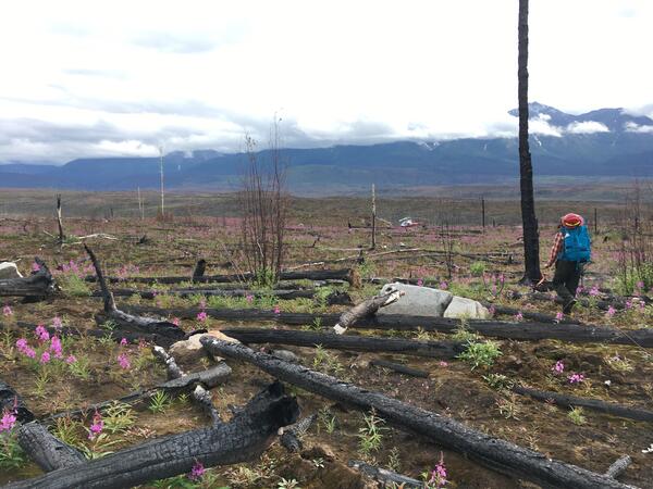
Wrangell–St. Elias National Park and Preserve After Wildfire
Wrangell–St. Elias National Park and Preserve After WildfireUSGS scientist conducts fieldwork in Wrangell-St. Elias National Park and Preserve following a wildfire.
Wrangell–St. Elias National Park and Preserve After Wildfire
Wrangell–St. Elias National Park and Preserve After WildfireUSGS scientist conducts fieldwork in Wrangell-St. Elias National Park and Preserve following a wildfire.