A scientist conducts winter instrument maintenance in interior Alaska surrounded by snow covered forest.
Images
Explore images taken during Ecosystems' Land Change Science Program fieldwork and research.
A scientist conducts winter instrument maintenance in interior Alaska surrounded by snow covered forest.
Avalanche debris covers a road in Glacier National Park at Red Rock point.
Sunset illuminates Sentinel Peak in the Cascade Range above South Cascade Glacier. Bright white seasonal snow is visible along the upper right flank of the glacier and banded bare ice is exposed toward the glacier terminus.
A scientist takes field notes on glacier mass change after measuring an ablation stake installed on the surface of South Cascade Glacier, Washington.
Young bog complex in winter at the Alaska Peatland Experiment (APEX) study site.
The sun rises over snow covered pine trees at the Alaska Peatland Experiment (APEX) study site near Fairbanks, Alaska.
USGS scientists drilling Santa Fe Lake, New Mexico as part of fieldwork conducted with the Did we start the fire? Climate, Fire and Humans project.
Researcher evaluates vegetation during a GLORIA alpine plant survey
Researcher evaluates vegetation during a GLORIA alpine plant surveyResearcher evaluates vegetation during a GLORIA alpine plant survey near the summit of Dancing Lady Mountain in Glacier National Park, Montana.
Researcher evaluates vegetation during a GLORIA alpine plant survey
Researcher evaluates vegetation during a GLORIA alpine plant surveyResearcher evaluates vegetation during a GLORIA alpine plant survey near the summit of Dancing Lady Mountain in Glacier National Park, Montana.
GLORIA sites within Glacier National Park
A botanist collects vegetation data near the summit of Pitamakin Mt
A botanist collects vegetation data near the summit of Pitamakin MtA botanist collects vegetation data near the summit Pitamakin Mountain in Glacier National Park, Montana.
A botanist collects vegetation data near the summit of Pitamakin Mt
A botanist collects vegetation data near the summit of Pitamakin MtA botanist collects vegetation data near the summit Pitamakin Mountain in Glacier National Park, Montana.
Scientists collect alpine plant species in Glacier NP
Scientists collect alpine plant species in Glacier NPScientists collect alpine plant species and distribution data to complete a GLORIA site inventory on the summit of Seward Mountain, Glacier National Park, Montana.
Scientists collect alpine plant species in Glacier NP
Scientists collect alpine plant species in Glacier NPScientists collect alpine plant species and distribution data to complete a GLORIA site inventory on the summit of Seward Mountain, Glacier National Park, Montana.
Alpine summits often support a great variety of vegetation species
Alpine summits often support a great variety of vegetation speciesAlpine summits often support a great variety of vegetation species despite harsh environmental conditions. Bison Mountain GLORIA plot, Glacier National Park, Montana.
Alpine summits often support a great variety of vegetation species
Alpine summits often support a great variety of vegetation speciesAlpine summits often support a great variety of vegetation species despite harsh environmental conditions. Bison Mountain GLORIA plot, Glacier National Park, Montana.
Global distribution of GLORIA sites.
USGS scientists collect field data at Gulkana Glacier in the eastern Alaska Range. The checkerboard sampling pattern in the foreground indicates where snow pit density measurements were collected.
A scientist checks data collection on multiple sensors at the Gulkana Glacier weather station where snow blankets the glacier surface.
Image showing the overview of a study site in the steep terrain of the Bridger Mountains of southwest Montanataken by an Uncrewed Aircraft System (UAS) while collecting data. The site’s complex terrain and topography are being studied to gain insights into snow depth and distribution in previously inaccessible areas.
SQUID-5 - Structure-from-Motion Quantitative Underwater Imaging Device
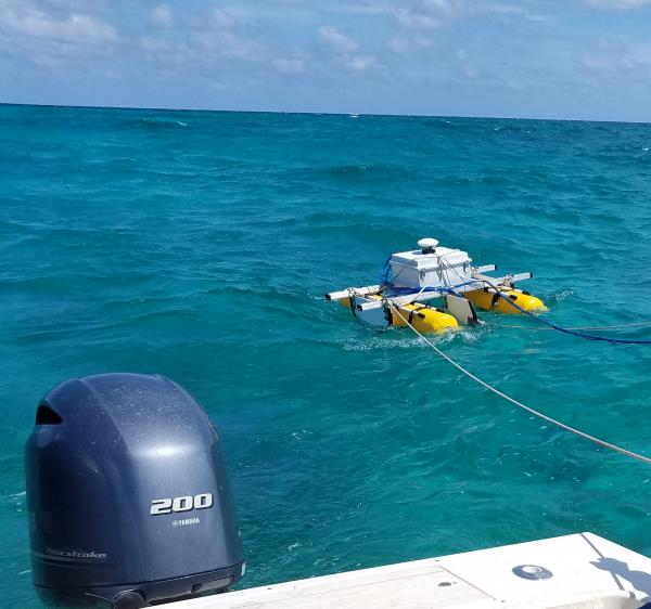
SQUID-5 - Structure-from-Motion Quantitative Underwater Imaging DeviceThe SQUID-5, or a Structure-from-Motion (SfM) Quantitative Underwater Imaging Device with 5 cameras is a towed surface vehicle with an onboard Global Navigation Satellite System (GNSS) and 5 downward-looking cameras with overlapping views of the seafloor.
SQUID-5 - Structure-from-Motion Quantitative Underwater Imaging Device
SQUID-5 - Structure-from-Motion Quantitative Underwater Imaging DeviceThe SQUID-5, or a Structure-from-Motion (SfM) Quantitative Underwater Imaging Device with 5 cameras is a towed surface vehicle with an onboard Global Navigation Satellite System (GNSS) and 5 downward-looking cameras with overlapping views of the seafloor.
A CTD-rosette is a commonly used instrument that measures conductivity (that can inform scientists about salinity), temperature, and depth (CTD). As the instrument is lowered into the water--sometimes down to great depths--the cylinders around will open at various depths to collect water samples at discrete locations throughout the water column.
Caitlin Reynolds with a sediment trap in the Gulf of Mexico
Caitlin Reynolds with a sediment trap in the Gulf of MexicoCaitlin Reynolds of the USGS St. Petersburg Coastal and Marine Science Center secures a sediment trap, retrieved from the bottom of the Gulf of Mexico on board the R/V Pelican.
Caitlin Reynolds with a sediment trap in the Gulf of Mexico
Caitlin Reynolds with a sediment trap in the Gulf of MexicoCaitlin Reynolds of the USGS St. Petersburg Coastal and Marine Science Center secures a sediment trap, retrieved from the bottom of the Gulf of Mexico on board the R/V Pelican.
A beautiful sun set over the Gulf of Mexico from the stern of the R/V Pelican.
Caitlin Reynolds collects samples from sediment trap
Caitlin Reynolds collects samples from sediment trapHere, Caitlin Reynolds sits on the R/V Pelican next to a sediment trap that collects samples in the Gulf of America.
Caitlin Reynolds collects samples from sediment trap
Caitlin Reynolds collects samples from sediment trapHere, Caitlin Reynolds sits on the R/V Pelican next to a sediment trap that collects samples in the Gulf of America.