



A large winch on the stern of R/V Pelican is used to retrieve two sediment traps from the bottom of the Gulf of Mexico.
Images
Explore images taken during Ecosystems' Land Change Science Program fieldwork and research.
Filter Total Items: 209

Retrieving a sediment trap in the Gulf of Mexico
A large winch on the stern of R/V Pelican is used to retrieve two sediment traps from the bottom of the Gulf of Mexico.

Caitlin Reynolds collects samples from sediment trap
Caitlin Reynolds collects samples from sediment trapHere, Caitlin Reynolds sits on the R/V Pelican next to a sediment trap that collects samples in the Gulf of America.
Caitlin Reynolds collects samples from sediment trap
Caitlin Reynolds collects samples from sediment trapHere, Caitlin Reynolds sits on the R/V Pelican next to a sediment trap that collects samples in the Gulf of America.

Various clues determine reliable coral samples
This piece of a core sample taken from offshore of the Fort Lauderdale region of Florida is from an elkhorn coral that lived 6,200 years ago. Coral type, orientation of corallites, and evidence of other fauna and characteristics within the core sample are used to determine how reliable the coral sample is to use for past sea-level reconstruction.
This piece of a core sample taken from offshore of the Fort Lauderdale region of Florida is from an elkhorn coral that lived 6,200 years ago. Coral type, orientation of corallites, and evidence of other fauna and characteristics within the core sample are used to determine how reliable the coral sample is to use for past sea-level reconstruction.

Coral-reef core from the USGS core archive
This core sample was taken from an elkhorn coral reef offshore of the Fort Lauderdale region of Florida. Samples from coral skeletons are taken from numerous locations in the core for radiocarbon dating, which tells scientists the age of each coral and of sections within the reef. The corals in this core lived from 7,100 to 6,200 years ago.
This core sample was taken from an elkhorn coral reef offshore of the Fort Lauderdale region of Florida. Samples from coral skeletons are taken from numerous locations in the core for radiocarbon dating, which tells scientists the age of each coral and of sections within the reef. The corals in this core lived from 7,100 to 6,200 years ago.
SQUID-5 - Structure-from-Motion Quantitative Underwater Imaging Device
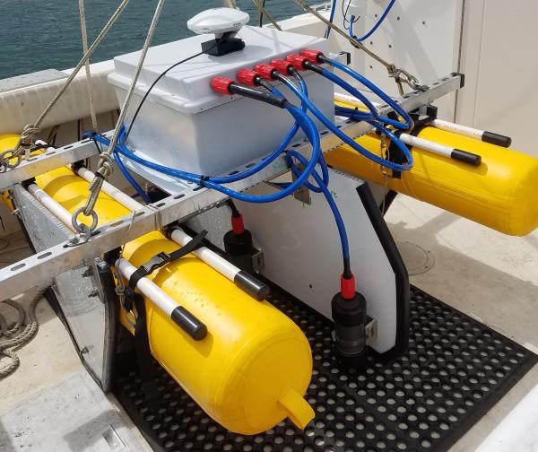
SQUID-5 - Structure-from-Motion Quantitative Underwater Imaging DeviceThe SQUID-5, or a Structure-from-Motion (SfM) Quantitative Underwater Imaging Device with 5 cameras is a towed surface vehicle with an onboard Global Navigation Satellite System (GNSS) and 5 downward-looking cameras with overlapping views of the seafloor.
SQUID-5 - Structure-from-Motion Quantitative Underwater Imaging Device
SQUID-5 - Structure-from-Motion Quantitative Underwater Imaging DeviceThe SQUID-5, or a Structure-from-Motion (SfM) Quantitative Underwater Imaging Device with 5 cameras is a towed surface vehicle with an onboard Global Navigation Satellite System (GNSS) and 5 downward-looking cameras with overlapping views of the seafloor.

Uncrewed aircraft system landing zone in Bridger Mountains
Uncrewed aircraft system landing zone in Bridger MountainsThe Uncrewed Aircraft System (UAS) landing zone with the study site in the background. Bridger Mountains, MT.
Uncrewed aircraft system landing zone in Bridger Mountains
Uncrewed aircraft system landing zone in Bridger MountainsThe Uncrewed Aircraft System (UAS) landing zone with the study site in the background. Bridger Mountains, MT.

Scientists use grids to collect alpine plant data according to GLORIA
Scientists use grids to collect alpine plant data according to GLORIAScientists use grids to collect alpine plant data according to GLORIA protocols on the summit of Bison Mountain in Glacier National Park, Montana.
Scientists use grids to collect alpine plant data according to GLORIA
Scientists use grids to collect alpine plant data according to GLORIAScientists use grids to collect alpine plant data according to GLORIA protocols on the summit of Bison Mountain in Glacier National Park, Montana.

Researchers evaluate vegetation during a GLORIA alpine plant survey
Researchers evaluate vegetation during a GLORIA alpine plant surveyResearchers evaluate vegetation during a GLORIA alpine plant survey near the summit of Seward Mountain in Glacier National Park, Montana.
Researchers evaluate vegetation during a GLORIA alpine plant survey
Researchers evaluate vegetation during a GLORIA alpine plant surveyResearchers evaluate vegetation during a GLORIA alpine plant survey near the summit of Seward Mountain in Glacier National Park, Montana.

Marine Sediment Cores from Southern Maryland
A USGS marine sediment core from southern Maryland. The changes in deposition at the PETM are clearly apparent in the core as it changes abruptly from dark sand (lower right side of box is oldest) to lighter clay (upper left side of box is youngest), indicating sudden environmental changes associated with a large pulse of atmospheric carbon.
A USGS marine sediment core from southern Maryland. The changes in deposition at the PETM are clearly apparent in the core as it changes abruptly from dark sand (lower right side of box is oldest) to lighter clay (upper left side of box is youngest), indicating sudden environmental changes associated with a large pulse of atmospheric carbon.
Marci Robinson Collecting Samples
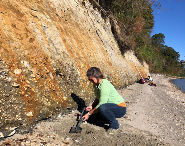
Marci Robinson collects sediment and fossilized shell samples from the Yorktown Formation in Virginia.
Marci Robinson collects sediment and fossilized shell samples from the Yorktown Formation in Virginia.

Repeat photography helps document glacier change
USGS scientists at the Northern Rocky Mountain Science Center use repeat photography to document glacier change and as a communication tool.
USGS scientists at the Northern Rocky Mountain Science Center use repeat photography to document glacier change and as a communication tool.

Scientists collect alpine plant species and distribution data in GNP
Scientists collect alpine plant species and distribution data in GNPScientists collect alpine plant species and distribution data to complete a GLORIA site inventory on the summit of Seward Mountain, Glacier National Park, Montana.
Scientists collect alpine plant species and distribution data in GNP
Scientists collect alpine plant species and distribution data in GNPScientists collect alpine plant species and distribution data to complete a GLORIA site inventory on the summit of Seward Mountain, Glacier National Park, Montana.

Live Foraminifera - Globorotalia truncatulinoides
Image of live, single-celled foram, Globorotalia truncatulinoides, viewed under a microscope and collected with a plankton net on the R/V Pelican. Its shell is made from Calcium carbonate and the spikes extensions are called rhizopodia.
Image of live, single-celled foram, Globorotalia truncatulinoides, viewed under a microscope and collected with a plankton net on the R/V Pelican. Its shell is made from Calcium carbonate and the spikes extensions are called rhizopodia.

USGS and USFWS Scientists at San Bernard National Wildlife Refuge, Texas
USGS and USFWS Scientists at San Bernard National Wildlife Refuge, TexasA USGS/USFWS team working at a coastal marsh site near a surface elevation table-marker horizon (SET-MH) station at San Bernard National Wildlife Refuge in Texas. Left to right, Tiffany Lane, Claudia Laurenzano, Laura Feher, Camille Stagg, Jena Moon, and Michael Osland. Taken via camera timer by the team, 10/3/2019.
USGS and USFWS Scientists at San Bernard National Wildlife Refuge, Texas
USGS and USFWS Scientists at San Bernard National Wildlife Refuge, TexasA USGS/USFWS team working at a coastal marsh site near a surface elevation table-marker horizon (SET-MH) station at San Bernard National Wildlife Refuge in Texas. Left to right, Tiffany Lane, Claudia Laurenzano, Laura Feher, Camille Stagg, Jena Moon, and Michael Osland. Taken via camera timer by the team, 10/3/2019.
Vegetation and soil research at long-term study sites in Canyonlands National Park
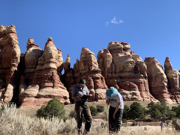
Vegetation and soil research at long-term study sites in Canyonlands National ParkUSGS and NPS staff conduct vegetation and soil research at long-term study sites in Canyonlands National Park, Utah.
Vegetation and soil research at long-term study sites in Canyonlands National Park
Vegetation and soil research at long-term study sites in Canyonlands National ParkUSGS and NPS staff conduct vegetation and soil research at long-term study sites in Canyonlands National Park, Utah.

Ablation Stake on Wolverine Glacier
An ablation stake which began the summer below the surface of the snow is shown here in the fall, extending far above bare ice surface of Wolverine Glacier, Alaska. A USGS scientist carries a portable steam drill, used to install the stakes in the glacier.
An ablation stake which began the summer below the surface of the snow is shown here in the fall, extending far above bare ice surface of Wolverine Glacier, Alaska. A USGS scientist carries a portable steam drill, used to install the stakes in the glacier.

Lassiter Swamp at Merchants Millpond State Park, NC
Lassiter Swamp at Merchants Millpond State Park, NCTree-ring analyses from Lassiter Swamp, located along a tributary of the Chowan River, indicate that cypress trees have occupied the site for at least 500 years. To extend the record even farther back in time, scientists from USGS, Duke University and East Carolina University are working together with students at C.S.
Lassiter Swamp at Merchants Millpond State Park, NC
Lassiter Swamp at Merchants Millpond State Park, NCTree-ring analyses from Lassiter Swamp, located along a tributary of the Chowan River, indicate that cypress trees have occupied the site for at least 500 years. To extend the record even farther back in time, scientists from USGS, Duke University and East Carolina University are working together with students at C.S.

Satellite Image of Wildfire Smoke Over Alaska
True-color image of wildfire smoke over Alaska on July 7, 2019 captured by the Moderate Resolution Imaging Spectroradiometer (MODIS) on NASA’s Terra satellite.
True-color image of wildfire smoke over Alaska on July 7, 2019 captured by the Moderate Resolution Imaging Spectroradiometer (MODIS) on NASA’s Terra satellite.

Researcher on Sperry Glacier
Researcher holds an ablation stake and winter snow probe during spring mass balance field work on Gulkana Glacier, AK.
Researcher holds an ablation stake and winter snow probe during spring mass balance field work on Gulkana Glacier, AK.

Partners discuss seasonal drought experiments.
Partners discuss seasonal drought experiments.
Partners discuss seasonal drought experiments.

Ice-rich Permafrost
A cross section of ice-rich permafrost. Layers and areas of sediments are interspersed with frozen patches of ice.
A cross section of ice-rich permafrost. Layers and areas of sediments are interspersed with frozen patches of ice.