Dixie Fire, Lassen Volcanic National Park, California (2021)
Dixie Fire, Lassen Volcanic National Park, California (2021)USGS crew measuring forest conditions following the Dixie Fire in 2021. Lassen Volcanic National Park. California.


Official websites use .gov
A .gov website belongs to an official government organization in the United States.

Secure .gov websites use HTTPS
A lock () or https:// means you’ve safely connected to the .gov website. Share sensitive information only on official, secure websites.

See more about our science.
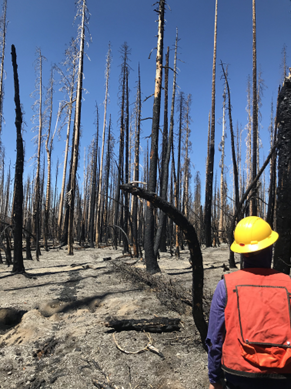
USGS crew measuring forest conditions following the Dixie Fire in 2021. Lassen Volcanic National Park. California.
USGS crew measuring forest conditions following the Dixie Fire in 2021. Lassen Volcanic National Park. California.

Historic cans from a refuse pile that were scorched by the combustion of nearby fuels during the Caldor Fire, California. Copyright: photo taken by Grant Snitker, New Mexico Consortium.
Historic cans from a refuse pile that were scorched by the combustion of nearby fuels during the Caldor Fire, California. Copyright: photo taken by Grant Snitker, New Mexico Consortium.

Setting up fuel transects within an archaeological site at Sequoia National Park to understand potential future fire behavior and how it could affect artifacts within the site. Pictured: Grant Snitker (foreground) and Alex Fetteroff (background), New Mexico Consortium. Copyright: Photo by Grant Snitker, New Mexico Consortium.
Setting up fuel transects within an archaeological site at Sequoia National Park to understand potential future fire behavior and how it could affect artifacts within the site. Pictured: Grant Snitker (foreground) and Alex Fetteroff (background), New Mexico Consortium. Copyright: Photo by Grant Snitker, New Mexico Consortium.

A precontact rockshelter and associated artifacts impacted by the combustion of heavy fuels during the KNP Complex Fire, California. Copyright: photo by Grant Snitker, New Mexico Consortium.
A precontact rockshelter and associated artifacts impacted by the combustion of heavy fuels during the KNP Complex Fire, California. Copyright: photo by Grant Snitker, New Mexico Consortium.

Using terrestrial LiDAR to characterize fuels within an archaeological site at Sequoia National Park site to understand potential future fire behavior and its effects on artifacts. Copyright: Photo by Grant Snitker, New Mexico Consortium.
Using terrestrial LiDAR to characterize fuels within an archaeological site at Sequoia National Park site to understand potential future fire behavior and its effects on artifacts. Copyright: Photo by Grant Snitker, New Mexico Consortium.

Graphic showing potential benefits of RestoreNet 2.0 treatments, including seeding, live topsoil inoculation, livestock grazing, seed balls, and soil pits
Graphic showing potential benefits of RestoreNet 2.0 treatments, including seeding, live topsoil inoculation, livestock grazing, seed balls, and soil pits

RestoreNet treatments include soil pits and connectivity modifiers (ConMods), seen here at a RestoreNet site in the Sonoran Desert.
RestoreNet treatments include soil pits and connectivity modifiers (ConMods), seen here at a RestoreNet site in the Sonoran Desert.

Ruby Lake National Wildlife Refuge lies at the southern end of Ruby Valley in northeast Nevada. For more information visit the Ruby Lake NWR website.
Ruby Lake National Wildlife Refuge lies at the southern end of Ruby Valley in northeast Nevada. For more information visit the Ruby Lake NWR website.

Two great horned owls sitting on a downed tree near the Columbia River in southwest Washington.
Two great horned owls sitting on a downed tree near the Columbia River in southwest Washington.

Lahontan cutthroat trout (Oncorhynchus clarkii henshawi) is a federally listed threatened species. Ninety-seven percent of their range are small headwater streams in the Great Basin of North America.
Lahontan cutthroat trout (Oncorhynchus clarkii henshawi) is a federally listed threatened species. Ninety-seven percent of their range are small headwater streams in the Great Basin of North America.

Land managers representing National Park Service, Bureau of Land Management, US Forest Service, Navajo Nation, private ranches and farms attend the first RestoreNet stakeholder meeting at the USGS Southwest Biological Science Center in February 2020.
Land managers representing National Park Service, Bureau of Land Management, US Forest Service, Navajo Nation, private ranches and farms attend the first RestoreNet stakeholder meeting at the USGS Southwest Biological Science Center in February 2020.

RAMPS expands drought adaptation project with national parks in the 4-Corners area. National parks across the desert Southwest are experiencing ecological impacts due to climate change.
RAMPS expands drought adaptation project with national parks in the 4-Corners area. National parks across the desert Southwest are experiencing ecological impacts due to climate change.

RAMPS met with DOI Office of Wildland Fire, US Customs and Border Patrol, and US Fish & Wildlife Service staff at Buenos Aires National Wildlife Refuge in southern AZ last November. The group is developing tools to reduce wildfire risk, conserve wildlife habitat and natural resources, and increase safety and security of border operations.
RAMPS met with DOI Office of Wildland Fire, US Customs and Border Patrol, and US Fish & Wildlife Service staff at Buenos Aires National Wildlife Refuge in southern AZ last November. The group is developing tools to reduce wildfire risk, conserve wildlife habitat and natural resources, and increase safety and security of border operations.

Arid grasslands in the U.S. Mexico border are fire adapted and used by diverse groups. Science from the Southwest Biological Science Center and the Restoration Assessment and Monitoring Program for the Southwest (RAMPS) is helping these groups find common ground to manage this dynamic landscape.
Arid grasslands in the U.S. Mexico border are fire adapted and used by diverse groups. Science from the Southwest Biological Science Center and the Restoration Assessment and Monitoring Program for the Southwest (RAMPS) is helping these groups find common ground to manage this dynamic landscape.

RestoreNet is a networked experiment testing treatments for improving restoration in drylands. Find out more at www.usgs.gov/sbsc/ramps
RestoreNet is a networked experiment testing treatments for improving restoration in drylands. Find out more at www.usgs.gov/sbsc/ramps

Adult Sage Thrasher waiting to deliver food to its nestlings.
Adult Sage Thrasher waiting to deliver food to its nestlings.

A USGS Hydrologic Technician collects eDNA samples alongside a stream in the Nevada wilderness
A USGS Hydrologic Technician collects eDNA samples alongside a stream in the Nevada wilderness

USGS Restoration Assessment and Monitoring Program for the Southwest (RAMPS) is helping to build capacity in ecosystem restoration on the Navajo Nation with a series of projects in collaboration with Navajo Nation Department of Natural Hertiage, Dine Native Plant Program, and the Native-led non-profit Tolani Lake Enterprises.
USGS Restoration Assessment and Monitoring Program for the Southwest (RAMPS) is helping to build capacity in ecosystem restoration on the Navajo Nation with a series of projects in collaboration with Navajo Nation Department of Natural Hertiage, Dine Native Plant Program, and the Native-led non-profit Tolani Lake Enterprises.
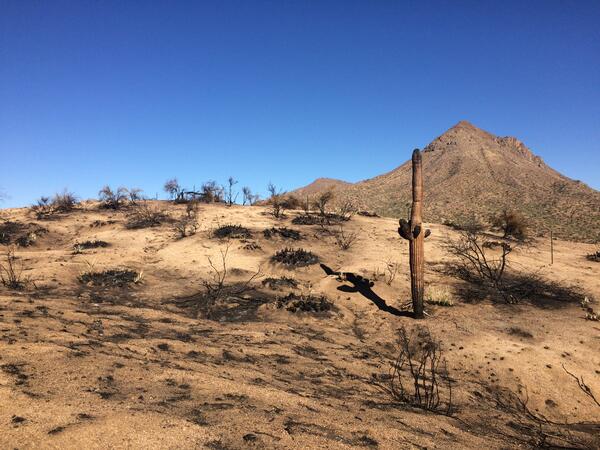
A post-fire landscape in the Tonto National Monument in the Sonoran Desert, Arizona after a wildland fire
A post-fire landscape in the Tonto National Monument in the Sonoran Desert, Arizona after a wildland fire

A Tetons sunrise in Antelope Flats, Wyoming.
A Tetons sunrise in Antelope Flats, Wyoming.

Left: RestoreNet outplant trials with greenhouse-grown seedlings planted into the field, Right: RestoreNet direct seeding trials with seeds combined with soil surface modifications including ConMod artificial nurse plants, mulch, and soil pits. Photos by Katie Laushman (USGS).
Left: RestoreNet outplant trials with greenhouse-grown seedlings planted into the field, Right: RestoreNet direct seeding trials with seeds combined with soil surface modifications including ConMod artificial nurse plants, mulch, and soil pits. Photos by Katie Laushman (USGS).