
A three-year drought is threatening to cause city officials in Cape Town, South Africa, to shut off the tap water. The growing city of nearly 4 million relies mostly on reservoirs for its water supply. While drought is part of the cause of the current crisis, an increasing population is also straining water resources.
Images
The National Land Imaging Program supports a variety of geospatial data programs and projects, including the USGS Landsat Program. Browse the images below to see some of the imagery produced using NLI-supported data sources.
Filter Total Items: 501

Theewaterskloof Reservoir, South Africa
A three-year drought is threatening to cause city officials in Cape Town, South Africa, to shut off the tap water. The growing city of nearly 4 million relies mostly on reservoirs for its water supply. While drought is part of the cause of the current crisis, an increasing population is also straining water resources.

Oil Fires in Iraq
Over the past few years, black smoke has been seen in satellite images billowing from various locations in Iraq. As Iraqi forces drive ISIS away, the terrorist group has been setting oil wells on fire as it retreats.
Over the past few years, black smoke has been seen in satellite images billowing from various locations in Iraq. As Iraqi forces drive ISIS away, the terrorist group has been setting oil wells on fire as it retreats.

From Chile to Your Smartphone
If you like being connected to the world everywhere you go with a smartphone or other device, then you have a desolate salt flat in northern Chile to thank.
If you like being connected to the world everywhere you go with a smartphone or other device, then you have a desolate salt flat in northern Chile to thank.

Update on Pine Island Glacier
A massive iceberg broke off Pine Island Glacier, Antarctica, in September 2017. Instead of drifting out to sea after calving, sea ice impeded the iceberg’s movement, and it cracked up into countless pieces nearly on the spot. Even though it broke up relatively quickly for an iceberg, it is more of a slow-motion shattering.
A massive iceberg broke off Pine Island Glacier, Antarctica, in September 2017. Instead of drifting out to sea after calving, sea ice impeded the iceberg’s movement, and it cracked up into countless pieces nearly on the spot. Even though it broke up relatively quickly for an iceberg, it is more of a slow-motion shattering.
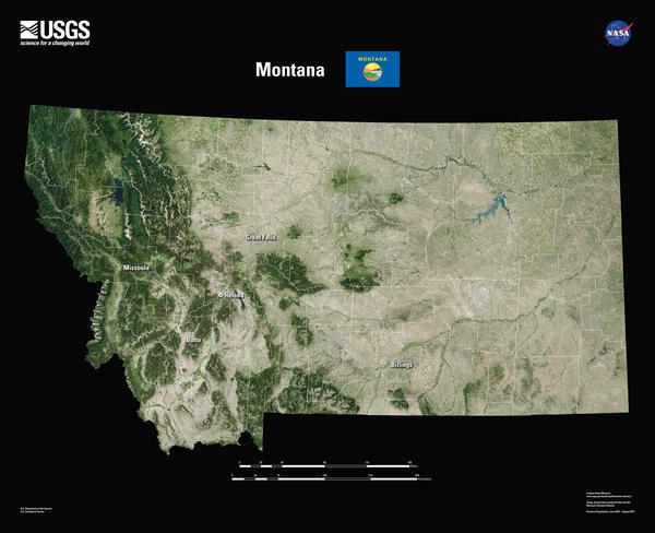
Montana Landsat State Mosaic
Cattle roam and forage across Montana’s wide-open spaces, with the beef
industry fueling the State’s economy. Landsat data are used to help guide
decisions on invasive species management, like controlling cheatgrass. Montana
researchers also use Landsat satellite data to map persistent snow and ice cover
in Glacier National Park.

Global Fiducials East Timbalier Island, LA
Paired images for East Timbalier Island (Louisiana) showing land mass difference over time.
Paired images for East Timbalier Island (Louisiana) showing land mass difference over time.
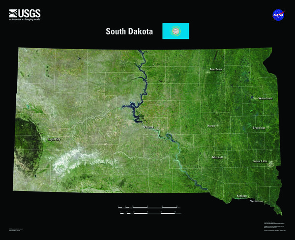
South Dakota Landsat State Mosaic
South Dakota is home to the fabled “Black Hills.” Seen from a distance, these pine-covered hills, rising several thousand feet above the surrounding prairie, appear black.
Capital Pierre
Image Source Landsat 8
Population 886,667
South Dakota is home to the fabled “Black Hills.” Seen from a distance, these pine-covered hills, rising several thousand feet above the surrounding prairie, appear black.
Capital Pierre
Image Source Landsat 8
Population 886,667
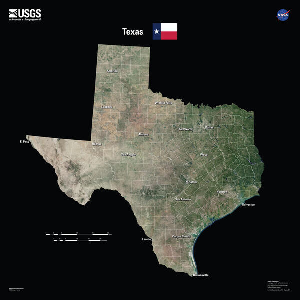
Texas Landsat State Mosaic
Tourists are drawn to the Texas coastline, but it is a frequent target of hurricanes.
Landsat documents storm damage and long-term coastal changes. Landsat data
are also used to study the urban heat island effect, helping communities identify
hotspots where human lives are at risk of heat-related illnesses. Because nearly

Gypsy Moth Infestation Continues in New England
A large outbreak of gypsy moth (Lymantria dispar) caterpillars attacked the hardwood forests of the northeastern United States in 2016. A fungus (Entomophaga maimaigaM) introduced from Japan has kept gypsy moth populations at relatively low levels since the late 1980s.
A large outbreak of gypsy moth (Lymantria dispar) caterpillars attacked the hardwood forests of the northeastern United States in 2016. A fungus (Entomophaga maimaigaM) introduced from Japan has kept gypsy moth populations at relatively low levels since the late 1980s.

Seeing Historic Route 66 from Above
Route 66 was established in November 1926. Named "The Mother Road" by John Steinbeck, the route is a cultural icon of America, symbolizing mobility and freedom.
We mark the route with this satellite mosaic and a combination of historical aerial photos and current aerial imagery from the USGS EROS Center archive.

Global Fiducials East Timbalier Island, LA
Paired images for East Timbalier Island (Louisiana) showing land mass difference over time.
Paired images for East Timbalier Island (Louisiana) showing land mass difference over time.
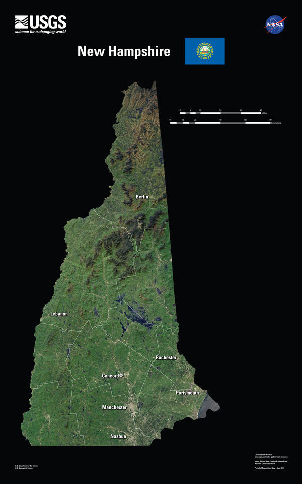
New Hampshire Landsat State Mosaic
In 1934, the summit of Mount Washington in New Hampshire’s White Mountains experienced a wind gust of 231 miles per hour, the highest surface wind speed ever recorded.
Capital Concord
Image Source Landsat 8
Population 1,377,529
In 1934, the summit of Mount Washington in New Hampshire’s White Mountains experienced a wind gust of 231 miles per hour, the highest surface wind speed ever recorded.
Capital Concord
Image Source Landsat 8
Population 1,377,529

Southern California Wildfires Update
In the Landsat 8 image acquired on December 9, smoke is carried west by strong winds, which also continued to spread fire through the dry terrain, mountain passes, and canyons. The diagonal lines are an airplane contrail and its shadow cast on the ground.
In the Landsat 8 image acquired on December 9, smoke is carried west by strong winds, which also continued to spread fire through the dry terrain, mountain passes, and canyons. The diagonal lines are an airplane contrail and its shadow cast on the ground.

Hurricane Sandy's Lasting Effects on Fire Island, NY
Hurricane Sandy's Lasting Effects on Fire Island, NYAs Hurricane Sandy made landfall on October 29, 2012, the storm’s waves and wind cut a breach in a narrow part of Fire Island, a barrier island south of Long Island, New York.
Hurricane Sandy's Lasting Effects on Fire Island, NY
Hurricane Sandy's Lasting Effects on Fire Island, NYAs Hurricane Sandy made landfall on October 29, 2012, the storm’s waves and wind cut a breach in a narrow part of Fire Island, a barrier island south of Long Island, New York.

Wildfires Devastate California Wine Country
Residents had little warning when wildfires that ignited late Sunday night, October 8, 2017, were fanned by wind gusts of 50 miles per hour and blasted across California's wine country. More than 100,000 acres have burned as of October 11, with less than 6 percent of the fires contained.
Residents had little warning when wildfires that ignited late Sunday night, October 8, 2017, were fanned by wind gusts of 50 miles per hour and blasted across California's wine country. More than 100,000 acres have burned as of October 11, with less than 6 percent of the fires contained.
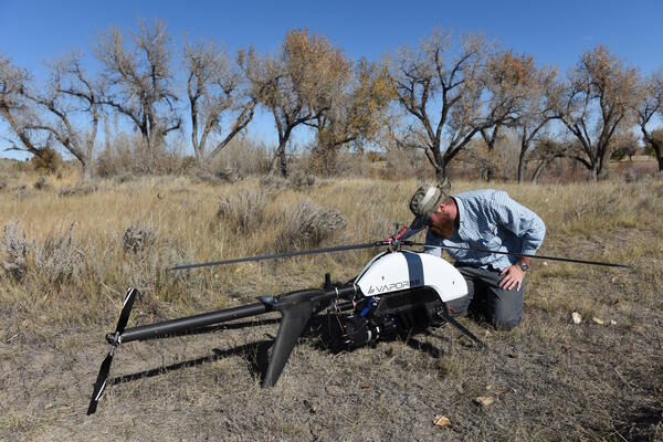
USGS researcher prepares a UAS with a mounted lidar sensor
USGS researcher prepares a UAS with a mounted lidar sensorUSGS researcher Todd Burton prepares a UAS with a mounted lidar sensor
At the request of the National Park Service in October 2017 the NUSO utilized UAS to acquire geospatial data to support development of a flood management plan for the Fort Laramie National Historic Site in Wyoming.

Pine Island Glacier’s Newest Iceberg
Pine Island Glacier in Antarctica has snapped off its share of icebergs in recent years. The frequency of noteworthy breaks is evidence that the ice shelf is becoming increasingly fragile. The latest iceberg cracked off the end of the Pine Island Glacier ice shelf around September 23, 2017.
Pine Island Glacier in Antarctica has snapped off its share of icebergs in recent years. The frequency of noteworthy breaks is evidence that the ice shelf is becoming increasingly fragile. The latest iceberg cracked off the end of the Pine Island Glacier ice shelf around September 23, 2017.

Puerto Rico after Hurricane Maria
This pair of Landsat 8 images shows the large-scale damage done to Puerto Rico. The lush green landscape in the 2016 image is replaced by a faded green. The strong winds stripped the leaves off trees to cause the degraded landscape. The forest is expected to recover.
This pair of Landsat 8 images shows the large-scale damage done to Puerto Rico. The lush green landscape in the 2016 image is replaced by a faded green. The strong winds stripped the leaves off trees to cause the degraded landscape. The forest is expected to recover.

Landsat 8 image of algal bloom in Lake Erie
In September 2017, Landsat 8's Operational Land Imager (OLI) Landsat 8 captured this image of a large phytoplankton bloom in Lake Erie, near Toledo, Ohio.
In September 2017, Landsat 8's Operational Land Imager (OLI) Landsat 8 captured this image of a large phytoplankton bloom in Lake Erie, near Toledo, Ohio.

Irma Churns Up Sediment in the Florida Keys
Hurricane Irma crossed the Florida Keys the morning of September 10, 2017, as a Category 4 hurricane with winds of 130 miles per hour. Besides damage done to structures on the islands, the storm also stirred the waters.
Hurricane Irma crossed the Florida Keys the morning of September 10, 2017, as a Category 4 hurricane with winds of 130 miles per hour. Besides damage done to structures on the islands, the storm also stirred the waters.

Hurricane Irma Slams Barbuda
The dramatic changes to the island caused by Irma, the strongest Atlantic hurricane on record, are shown in this pair of images from Landsat 8. Landsat uses shortwave-infrared, near-infrared, and green wavelengths to reveal those changes. The August 27 image shows healthy vegetation as bright green.
The dramatic changes to the island caused by Irma, the strongest Atlantic hurricane on record, are shown in this pair of images from Landsat 8. Landsat uses shortwave-infrared, near-infrared, and green wavelengths to reveal those changes. The August 27 image shows healthy vegetation as bright green.