
Modeling Tools
Modeling Tools
Filter Total Items: 50

North Pacific Pelagic Seabird Database
The North Pacific Pelagic Seabird Database (NPPSD) contains survey transect data designed and conducted by numerous partners primarily to census seabirds at sea. The NPPSD includes more than 486,000 transect segments and includes observations of over 20 million birds of 258 species collected over the span of 50 years (from 1973 to 2022).
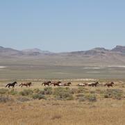
Science for management of America’s iconic wild horses and burros
Wild horses and burros are iconic wildlife of the western USA as well as a complicated management issue on tribal, state, and federal lands. Due to their history as domesticated animals, these wild equids – also called “free-roaming” or “feral” equids – can reproduce quickly, and have few natural predators, allowing their populations to grow rapidly if not managed. When populations are too large...

Greater Sage-Grouse Population Monitoring Framework: Cheat Sheet
The Greater Sage-grouse Population Monitoring Framework fills a prominent information gap to help inform current assessments of sage-grouse population trends at nested spatial and temporal scales. It is centered on four objectives: (1) create a standardized database of lek counts; (2) develop biologically based spatial population structures by clustering leks; (3) estimate spatial trends at...

Greater Sage-Grouse Population Monitoring Framework
Greater sage-grouse ( Centrocercus urophasianus) are at the center of state and national land use policies largely because of their unique life-history traits and their role as an ecological indicator for the health of sagebrush ecosystems. Multiple science centers with the U.S. Geological Survey (USGS) in conjunction with Colorado State University (CSU) have developed the Greater Sage-Grouse...

A user-friendly decision support tool for monitoring and managing greater sage-grouse populations
Researchers at the U.S. Geological Survey (USGS) and Colorado State University (CSU) collaborated with the Bureau of Land Management and state wildlife agencies to develop a hierarchical population monitoring framework for managing greater sage-grouse ( Centrocercus urophasianus) populations and the sagebrush ecosystems they depend on for survival and reproduction. This greater sage-grouse...

A targeted annual warning system (TAWS) for identifying aberrant declines in greater sage-grouse populations
Land and wildlife managers require accurate estimates of sensitive species’ trends to help guide conservation decisions that maintain biodiversity and promote healthy ecosystems. Multiple science centers with the U.S. Geological Survey (USGS), in conjunction with Colorado State University (CSU), developed a hierarchical population monitoring framework for managing greater sage-grouse (...

USGS Sagebrush Science: Supporting Public Safety and Economic Decision Making Across the West
The sagebrush biome is one of the largest ecosystems in North America. Encompassing nearly one-third of the continental U.S., it provides critical resources for millions of Americans and a home for hundreds of plants and animal species in the West. Natural resource management in sagebrush ecosystems can be complex, and science can support management decisions by providing knowledge and tools to...
By
Core Science Systems Mission Area, Ecosystems Mission Area, Biological Threats and Invasive Species Research Program, Climate Adaptation Science Centers, Cooperative Research Units, Land Management Research Program, Species Management Research Program, Earth Resources Observation and Science (EROS) Center, Forest and Rangeland Ecosystem Science Center, Fort Collins Science Center, Northern Rocky Mountain Science Center, Southwest Biological Science Center, Western Ecological Research Center (WERC), Wildland Fire Science

Tracking Data for Spectacled Eiders (Somateria fischeri)
Available here are tracking data of Spectacled Eider, a sea duck species that breeds only in Alaska and Russia and spends the winter exclusively in the Bering Sea. The Alaska breeding population is listed as threatened under provisions of the Endangered Species Act. These data were collected to better understand the winter distribution in the Bering Sea and locate birds for winter aerial surveys...

Key Values of a Century of EESC Science
The USGS Eastern Ecological Science Center (EESC) is rooted in a proud tradition of service to the nation—advancing science that informs the conservation and management of fish, wildlife, and habitats across the eastern United States and beyond. Our mission is clear: deliver reliable, partner-driven science that supports natural resource decisions today, while ensuring these resources remain...

USGS Alaska Science Center Wildlife Tracking Data Collection
Understanding the short- and long-distance movements of wildlife is critical for a wide variety of ecological research questions and management decisions. Since the mid-1980s, the USGS Alaska Science Center has used information from telemetry devices on wildlife species to determine locations of animals throughout their annual cycles, understand patterns of habitat use, quantify time spent on...

Counting America’s Wild Horses and Burros: Better Estimates for Population Management
The Wild Free-Roaming Horses and Burros Act of 1971, as amended, states that, "It is the policy of Congress that wild free-roaming horses and burros shall be protected from capture, branding, harassment, or death; and to accomplish this they are to be considered in the area where presently found, as an integral part of the natural system of the public lands (PL 92-195, Sec. 1331, Congressional...

Population Ecology of Florida Manatees
USGS is working with partners to understand how the federally protected Florida manatee ( Trichechus manatus latirostris) population changes over time and responds to threats.