
Sometimes the fog can be as thick as pea soup! The captains use radar and keen eyesight to navigate in such conditions. Woods Hole Coastal and Marine Science Center staff, Alex Nichols and Wayne Baldwin, take a sound velocity cast off the back of the boat.
Images
Images below come from a wide variety of USGS science activities in the Northeast Region. Science Center staff showcase what we do, who we are, and where we work conducting science that inform decision makers and addresses societal needs.
Filter Total Items: 2050

Sound velocity casts on Cape Cod Bay
Sometimes the fog can be as thick as pea soup! The captains use radar and keen eyesight to navigate in such conditions. Woods Hole Coastal and Marine Science Center staff, Alex Nichols and Wayne Baldwin, take a sound velocity cast off the back of the boat.

Securing the streamer
The start of the Cape Cod Bay 2019 Survey. Eric, Wayne, and Dave are made sure the streamer was ready for when they reach the study area.
The start of the Cape Cod Bay 2019 Survey. Eric, Wayne, and Dave are made sure the streamer was ready for when they reach the study area.

Boston, MA cityscape
Heading back to Cape Cod Bay after a crew change in Boston, MA
Heading back to Cape Cod Bay after a crew change in Boston, MA

Let me process this
Seth Ackerman processing the seafloor mapping data as they are collected on the Cape Cod Bay 2019 research cruise.
Seth Ackerman processing the seafloor mapping data as they are collected on the Cape Cod Bay 2019 research cruise.

Children's School of Science
USGS scientist Seth Ackerman shows students at the Children's School of Science how we map the seafloor. This was part of the pre-cruise for the Cape Cod Bay 2019 Survey.
USGS scientist Seth Ackerman shows students at the Children's School of Science how we map the seafloor. This was part of the pre-cruise for the Cape Cod Bay 2019 Survey.

HRECOS gage Pier 26 New York, NY
Riley Behrens and Anthony Cacace are replacing an intake on Hudson River Environmental Conditions Observing System (HRECOS) gage 01376520 Hudson River at Pier 26 at New York, NY.
Riley Behrens and Anthony Cacace are replacing an intake on Hudson River Environmental Conditions Observing System (HRECOS) gage 01376520 Hudson River at Pier 26 at New York, NY.
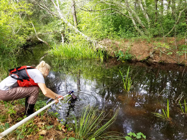
Water quality sample collection at Herring River in Wellfleet, Massachusetts
Water quality sample collection at Herring River in Wellfleet, MassachusettsCape Cod National Seashore (CACO) NPS staff collecting a water quality sample at Station 20, Herring River in Wellfleet, Massachusetts as a part of the large-scale Herring River Restoration Project. The Station 20 site is one of three sites to monitor dissolved oxygen concentrations.
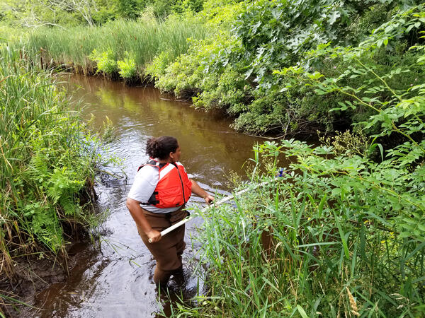
Water quality sample collection at Herring River estuary in Wellfleet, Massachusetts
Water quality sample collection at Herring River estuary in Wellfleet, MassachusettsCape Cod National Seashore (CACO) NPS staff collecting a water quality sample at Station 14, Herring River in Wellfleet, Massachusetts as a part of the large-scale Herring River Restoration Project. The Station 14 site is one of 11 sites which samples were analyzed for concentrations of sediment, chlorophyll, nitrogen, and phosphorus.

Schoharie Creek during a fish community survey
A blocking seine prevents fish from moving in or out of a study reach on the Schoharie Creek during a fish community survey conducted on July 18th by Scott George, Barry Baldigo, and technicians from the New York Water Science Center. Photo by Scott George
A blocking seine prevents fish from moving in or out of a study reach on the Schoharie Creek during a fish community survey conducted on July 18th by Scott George, Barry Baldigo, and technicians from the New York Water Science Center. Photo by Scott George

Meteorological Weather and Real-Time Groundwater Site Inspection
Meteorological Weather and Real-Time Groundwater Site InspectionShown in this photo is Hydrologic Technician Sam Banas performing a routine site inspection of this meteorological weather and real-time groundwater well station.
Meteorological Weather and Real-Time Groundwater Site Inspection
Meteorological Weather and Real-Time Groundwater Site InspectionShown in this photo is Hydrologic Technician Sam Banas performing a routine site inspection of this meteorological weather and real-time groundwater well station.

Scenic photo of the North River in Shattuckville, Massachusetts
Scenic photo of the North River in Shattuckville, MassachusettsScenic photo of the North River in Shattuckville, Massachusetts taken during a cloudy day.
Scenic photo of the North River in Shattuckville, Massachusetts
Scenic photo of the North River in Shattuckville, MassachusettsScenic photo of the North River in Shattuckville, Massachusetts taken during a cloudy day.

Dragonfly on tagline
Northeast Region Photo Contest Winner | Sept 2019 | Honorable Mention
Dragonfly on tagline
Northeast Region Photo Contest Winner | Sept 2019 | Honorable Mention
Dragonfly on tagline

Modeling FEMA Flood Insurance Rate Maps
Surface Water Modeling for FEMA Flood Insurance Rate Maps.
USGS employee using survey data to model water surface elevation for different storm events.
Surface Water Modeling for FEMA Flood Insurance Rate Maps.
USGS employee using survey data to model water surface elevation for different storm events.

Locating survey site using Collector app
Surface Water Modeling for FEMA Flood Insurance Rate Maps.
USGS employee uses Collector App to locate the survey site.
Surface Water Modeling for FEMA Flood Insurance Rate Maps.
USGS employee uses Collector App to locate the survey site.

Setting up a total station on the edge of a field
Surface Water Modeling for FEMA Flood Insurance Rate Maps.
USGS employees are setting up a total station on the edge of a field in preparation to make a channel measurement.
Surface Water Modeling for FEMA Flood Insurance Rate Maps.
USGS employees are setting up a total station on the edge of a field in preparation to make a channel measurement.

Hiking in to the survey site
Surface Water Modeling for FEMA Flood Insurance Rate Maps.
USGS employees carry survey equipment to the survey site. They are hiking down a grassy hill in a farmers field in Connecticut.
Surface Water Modeling for FEMA Flood Insurance Rate Maps.
USGS employees carry survey equipment to the survey site. They are hiking down a grassy hill in a farmers field in Connecticut.

Levels being run at 03250215 Slate Creek at Owingsville, KY
Levels being run at 03250215 Slate Creek at Owingsville, KYNortheast Region Photo Contest Winner | Sept 2019 | Honorable Mention
Levels being run at 03250215 Slate Creek at Owingsville, KY. Andrew Vanover (level gun operator) and Brian Moore (rod operator).

Aerial photo of estuary
Aerial view of a gas flux tower in Great Barnstable Marsh in Barnstable, Massachusetts.
Aerial view of a gas flux tower in Great Barnstable Marsh in Barnstable, Massachusetts.

Elevation survey in the Jones River, Kingston, MA
Research scientist Meagan Gonneea and USGS intern Angela Trejo survey the Jones River in Kingston, MA. Removal of a dam across the Jones River began July 15, 2019, as a first step to restore river habitat, which is particularly critical for herring passage from the sea to inland lakes for spawning.
Research scientist Meagan Gonneea and USGS intern Angela Trejo survey the Jones River in Kingston, MA. Removal of a dam across the Jones River began July 15, 2019, as a first step to restore river habitat, which is particularly critical for herring passage from the sea to inland lakes for spawning.

Yellow River at Knox, IN - bridge measurement
Yellow River at Knox, IN - bridge measurement

Setting up a total station near an old factory
Surface Water Modeling for FEMA Flood Insurance Rate Maps.
USGS employees are setting up a total station near an old factory in preparation of taking a channel measurement.
Surface Water Modeling for FEMA Flood Insurance Rate Maps.
USGS employees are setting up a total station near an old factory in preparation of taking a channel measurement.