
Damaged pier from effects of Hurrican Sandy on Long Island, NY.
Images
Images below come from a wide variety of USGS science activities in the Northeast Region. Science Center staff showcase what we do, who we are, and where we work conducting science that inform decision makers and addresses societal needs.
Filter Total Items: 2050

Hurricane Sandy damaged pier on Long Island
Damaged pier from effects of Hurrican Sandy on Long Island, NY.

ADCP Measurement at Bingham - Station 01046500
This ADCP sends an acoustic pulse into the water to measure the speed of the water, the depth of the river and to measure how far it's moved across the river. With this information, it can compute discharge.
This ADCP sends an acoustic pulse into the water to measure the speed of the water, the depth of the river and to measure how far it's moved across the river. With this information, it can compute discharge.

ADCP Measurement at Bingham - Station 01046500
A manned boat is used to ferry the ADCP back and forth across the river. The velocities at this section were quite slow, and the line across the river allowed better control than driving the small boat.
A manned boat is used to ferry the ADCP back and forth across the river. The velocities at this section were quite slow, and the line across the river allowed better control than driving the small boat.

ADCP Measurement at Bingham - Station 01046500
Another view of the manned boat, with ADCP attached.
Another view of the manned boat, with ADCP attached.

ADCP Measurement at Bingham - Station 01046500
This is the view downstream of the cross section.
This is the view downstream of the cross section.

ADCP Measurement at Bingham - Station 01046500
This is the view upstream of the cross section.
This is the view upstream of the cross section.

ADCP Measurement at Bingham - Station 01046500
This is the cross section where the measurement was made and the line we strung across the river, marked with flagging for visibility. In slow velocities, the line helps control the speed of the boat as it is moved across the channel.
This is the cross section where the measurement was made and the line we strung across the river, marked with flagging for visibility. In slow velocities, the line helps control the speed of the boat as it is moved across the channel.

Sediment sampling - Long Island
Sediment sampling off the coast of Long Island, NY.
Sediment sampling off the coast of Long Island, NY.

Streamgage measurement
Hydrologic Technician taking a streamgage measurement at USGS 01104415 in the Cambridge Reservoir Watershed, Massachusetts.
Hydrologic Technician taking a streamgage measurement at USGS 01104415 in the Cambridge Reservoir Watershed, Massachusetts.

NYWSC scientist is collecting groundwater samples
NYWSC scientist collecting groundwater samples

Indiana Harbor Canal at East Chicago, IN - measurement
Indiana Harbor Canal at East Chicago, IN - measurementIndiana Harbor Canal at East Chicago, IN - measurement - Andy Gorman
Indiana Harbor Canal at East Chicago, IN - measurement
Indiana Harbor Canal at East Chicago, IN - measurementIndiana Harbor Canal at East Chicago, IN - measurement - Andy Gorman

Indiana Harbor Canal at East Chicago, IN - ADCP measurement
Indiana Harbor Canal at East Chicago, IN - ADCP measurementIndiana Harbor Canal at East Chicago, IN - ADCP measurement - Moriah Will
Indiana Harbor Canal at East Chicago, IN - ADCP measurement
Indiana Harbor Canal at East Chicago, IN - ADCP measurementIndiana Harbor Canal at East Chicago, IN - ADCP measurement - Moriah Will

Indiana Harbor Canal at East Chicago, IN - walk bridge
Indiana Harbor Canal at East Chicago, IN - walk bridgeIndiana Harbor Canal at East Chicago, IN - walk bridge
Indiana Harbor Canal at East Chicago, IN - walk bridge
Indiana Harbor Canal at East Chicago, IN - walk bridgeIndiana Harbor Canal at East Chicago, IN - walk bridge
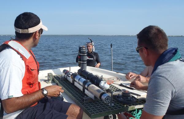
Shallow Water Irradience Platform placement in Barnegat Bay, NJ
Shallow Water Irradience Platform placement in Barnegat Bay, NJInvestigators prepare to place a Shallow Water Irradience Platform (SWIP) at a site in Barnegat Bay, NJ.
Shallow Water Irradience Platform placement in Barnegat Bay, NJ
Shallow Water Irradience Platform placement in Barnegat Bay, NJInvestigators prepare to place a Shallow Water Irradience Platform (SWIP) at a site in Barnegat Bay, NJ.

Salt Marsh Research
USGS research supports wetland conservation as critical habitat, Cape Cod, MA
USGS research supports wetland conservation as critical habitat, Cape Cod, MA

USGS and Summer Interns from the Partnership Education Program (PEP) p
USGS and Summer Interns from the Partnership Education Program (PEP) pUSGS and Summer Interns from the Partnership Education Program (PEP) program sampling over a tidal cycle.
USGS and Summer Interns from the Partnership Education Program (PEP) p
USGS and Summer Interns from the Partnership Education Program (PEP) pUSGS and Summer Interns from the Partnership Education Program (PEP) program sampling over a tidal cycle.

Equipment used for a measuring lateral fluxes over tidal cycle
Equipment used for a measuring lateral fluxes over tidal cycleEquipment used for a measuring lateral fluxes over tidal cycle
Equipment used for a measuring lateral fluxes over tidal cycle
Equipment used for a measuring lateral fluxes over tidal cycleEquipment used for a measuring lateral fluxes over tidal cycle

Ohio Nowcast
As schools close for the year and summer weather beckons, many recreationalists head to the Great Lakes' public beaches. However, these coastal areas can become contaminated with disease-causing bacteria that threaten public health, disrupt water recreation, and pay a toll on the Great Lakes economies that depend on summer tourism.
As schools close for the year and summer weather beckons, many recreationalists head to the Great Lakes' public beaches. However, these coastal areas can become contaminated with disease-causing bacteria that threaten public health, disrupt water recreation, and pay a toll on the Great Lakes economies that depend on summer tourism.

Deploying a measure flow, Rachel Carlson National Wildlife Refuge
Deploying a measure flow, Rachel Carlson National Wildlife RefugeA sensor is deployed to measure flow in a channel of the marsh in Rachel Carlson National Wildlife Refuge in 2013.
Deploying a measure flow, Rachel Carlson National Wildlife Refuge
Deploying a measure flow, Rachel Carlson National Wildlife RefugeA sensor is deployed to measure flow in a channel of the marsh in Rachel Carlson National Wildlife Refuge in 2013.

Rock Castle, VA
View looking east from the Virginia Blue Ridge across the Rock Castle Creek gorge to the rolling hills of the Piedmont.
View looking east from the Virginia Blue Ridge across the Rock Castle Creek gorge to the rolling hills of the Piedmont.

Huron River at Milan, OH - upstream
Huron River at Milan, OH - upstream