
Li Erikson
Research Oceanographer at the USGS Pacific Coastal and Marine Science Center
Science and Products
Filter Total Items: 22

CoSMoS 2.2: Pt. Arena and Russian River
Building on the initial work in the Bay Area and Outer Coast, CoSMoS 2.2 adds river flows to help users project combined river and coastal flooding along the northern California coast from Bodega Head to Point Arena.

CoSMoS 3.0: Southern California
CoSMoS 3.0 for southern California provides detailed predictions of coastal flooding due to both future sea-level rise and storms, integrated with predictions of long-term coastal evolution (beach changes and coastal cliff retreat) for the Southern California region, from Point Conception (Santa Barbara County) to Imperial Beach (San Diego County).

CoSMoS 2.1: San Francisco Bay
With primary support from the National Estuarine Research Reserve (NERR), CoSMoS is set-up within the San Francisco Bay as part of Our Coast Our Future (OCOF).

CoSMoS 2.0: North-central California (outer coast)
Our Coast Our Future (OCOF) is a collaborative, user-driven project providing science-based decision-support tools to help coastal planners and emergency responders understand, visualize, and anticipate local impacts from sea-level rise (SLR) and storms in the San Francisco Bay region.

Climate impacts to Arctic coasts, recent activities
USGS activities related to the project, "Climate Impacts to Arctic Coasts."
San Francisco Bay Basic Tide Model
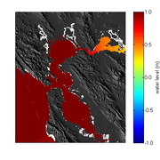
This web page provides files that may be used to run a basic depth-averaged (2DH) Deltares Delft3D version 4.00.01 astronomic tide model for San Francisco Bay. It was developed with the primary aim of assessing water level fluctuations and flow conditions in the vicinity of the Golden Gate (Elias and Hansen 2013).
Using Video Imagery to Study Coastal Change: Barter Island, Alaska
For a short study period, two video cameras overlooked the coast from atop the coastal bluff of Barter Island in northern Alaska. The purpose was to observe and quantify coastal processes such as wave run-up, development of rip channels, bluff erosion, and movement of sandbars and ice floes.

Operational CoSMoS model: San Francisco Bay
The San Francisco Bay Coastal Flood Forecast pilot project is an operational CoSMoS model, part of a project funded by the California Department of Water Resources (CA-DWR) and NOAA’s Earth System Research Laboratory (ESRL).

PS-CoSMoS FAQs PS-CoSMoS FAQs
Puget Sound - Coastal Storm Modeling System (PS-CoSMoS) frequently asked questions

CoSMoS 1.0: Southern California
CoSMoS was initially developed and tested for the Southern California coast in collaboration with Deltares. CoSMoS has been used to assess coastal vulnerability within Southern California for the ARkStorm scenario, the January 2010 El Niño and Sea-Level Rise scenarios, and the January 2005 Newport Harbor Flood scenario.
Science and Products
Filter Total Items: 22
CoSMoS 2.2: Pt. Arena and Russian River
Building on the initial work in the Bay Area and Outer Coast, CoSMoS 2.2 adds river flows to help users project combined river and coastal flooding along the northern California coast from Bodega Head to Point Arena.
CoSMoS 3.0: Southern California
CoSMoS 3.0 for southern California provides detailed predictions of coastal flooding due to both future sea-level rise and storms, integrated with predictions of long-term coastal evolution (beach changes and coastal cliff retreat) for the Southern California region, from Point Conception (Santa Barbara County) to Imperial Beach (San Diego County).
CoSMoS 2.1: San Francisco Bay
With primary support from the National Estuarine Research Reserve (NERR), CoSMoS is set-up within the San Francisco Bay as part of Our Coast Our Future (OCOF).
CoSMoS 2.0: North-central California (outer coast)
Our Coast Our Future (OCOF) is a collaborative, user-driven project providing science-based decision-support tools to help coastal planners and emergency responders understand, visualize, and anticipate local impacts from sea-level rise (SLR) and storms in the San Francisco Bay region.
Climate impacts to Arctic coasts, recent activities
USGS activities related to the project, "Climate Impacts to Arctic Coasts."
San Francisco Bay Basic Tide Model
This web page provides files that may be used to run a basic depth-averaged (2DH) Deltares Delft3D version 4.00.01 astronomic tide model for San Francisco Bay. It was developed with the primary aim of assessing water level fluctuations and flow conditions in the vicinity of the Golden Gate (Elias and Hansen 2013).
Using Video Imagery to Study Coastal Change: Barter Island, Alaska
For a short study period, two video cameras overlooked the coast from atop the coastal bluff of Barter Island in northern Alaska. The purpose was to observe and quantify coastal processes such as wave run-up, development of rip channels, bluff erosion, and movement of sandbars and ice floes.
Operational CoSMoS model: San Francisco Bay
The San Francisco Bay Coastal Flood Forecast pilot project is an operational CoSMoS model, part of a project funded by the California Department of Water Resources (CA-DWR) and NOAA’s Earth System Research Laboratory (ESRL).
PS-CoSMoS FAQs PS-CoSMoS FAQs
Puget Sound - Coastal Storm Modeling System (PS-CoSMoS) frequently asked questions
CoSMoS 1.0: Southern California
CoSMoS was initially developed and tested for the Southern California coast in collaboration with Deltares. CoSMoS has been used to assess coastal vulnerability within Southern California for the ARkStorm scenario, the January 2010 El Niño and Sea-Level Rise scenarios, and the January 2005 Newport Harbor Flood scenario.