

Photo of restoration structures in the Deer Island restoration site, Missouri River, during April 2014.
Robert Jacobson, PhD (Former Employee)
Science and Products
Filter Total Items: 14

CERC Eco-flume
The CERC Eco-flume is a continuous-loop, racetrack style flume. It is housed in a 1,350 square-foot laboratory at CERC and will be used to study transport phenomena and biophysical processes in river environments.

Exploring the Potential for Conservation Lands in Middle Mississippi River Floodplains to Mitigate Flood Flows for Ecosystem Services
Reconnection of floodplains to their rivers has been considered a fundamentally beneficial ecological practice.

Missouri River Recovery Implementation Committee (MRRIC) and Adaptive Management
This project centers on assimilation of data, interpretation of results, updating quantitative models, and providing policy-neutral, high-quality information to the agencies and stakeholders in the Missouri River Basin.

River-Corridor Habitat Dynamics
River-Corridor Habitat Dynamics research seeks to improve the scientific basis for ecological restoration of large rivers. Emphasis is placed on understanding how hydrologic and geomorphic characteristics combine to create dynamic habitats for native and exotic fauna and flora.

Synthesis of Hydrologic and Geomorphic Drivers of Riverine Habitat Dynamics
Habitats of many rivers of the US are perceived to be degraded as a result of human-induced stresses. CERC scientist are focusing physical habitat as measured by depth, velocity, and substrate, in order to establish relevance of physical habitat to biota.

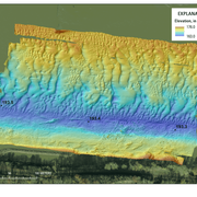
Geomorphic Trends and Dynamics, Missouri National Recreational River
The two mainstem Missouri River segments of the Missouri National Recreational River (MNRR) represent some of the least altered channel form and most complex physical habitat on the Missouri River. The 39-mile segment is located in an inter-reservoir reach between Fort Randall Dam and Lewis and Clark Lake and the 59-mile segment is located below Gavins Point Dam, the downstream-most water control...

Comprehensive Sturgeon Research Project (CSRP)
The Comprehensive Sturgeon Research Project (CSRP) is a multidisciplinary project conducted in cooperation with the U.S. Army Corps of Engineers, Missouri River Recovery Program–Integrated Science Program. CERC scientists are working with river scientists and managers to develop methods, baseline information, and research approaches that are critical contributions to recovery success of the...

Ecological Structure and Function, Large-River Floodplains
This project seeks to develop tools and datasets that provide insights to the common ground between flood-risk reduction and ecosystem services on large-river floodplains of the Central United States. Floodplains of large rivers are valued for their agricultural productivity and development potential, but recent floods have demonstrated the high costs and lack of resiliency when floodplains are...
Pallid Sturgeon Habitat Dynamics
CERC scientists apply advanced measurement and modeling approaches to quantifying habitats in large rivers. Our research has been applied to improving the understanding of the reproductive ecology of the endangered pallid sturgeon ( Scaphirhynchus albus) in the Missouri River.

Science to Inform Management of Floodplain Conservation Lands in a Changing World
Recent extreme floods on the Mississippi and Missouri Rivers have motivated decision-makers and resource managers to expaned floodplain conservation lands. Within Missouri, there are more than 85,000 acres of public conservation lands in large-river floodplains. Floodplain lands are highly dynamic and challenging to manage, particularly climatic conditions change. These lands have the...

SERAP: The Effects of Climate Change on Aquatic Species and Habitat in the Southeast
USGS researchers assessed how climate change can affect land cover and flow in river systems, examining a variety of resolutions for detecting and projecting the conditions of aquatic habitats and species.

Deer Island, Missouri River Restoration Site
Photo of restoration structures in the Deer Island restoration site, Missouri River, during April 2014.

The R/V Slim Funk
The Columbia Environmental Research Center's R/V Slim Funk is shown.
The Columbia Environmental Research Center's R/V Slim Funk is shown.
Science and Products
Filter Total Items: 14
CERC Eco-flume
The CERC Eco-flume is a continuous-loop, racetrack style flume. It is housed in a 1,350 square-foot laboratory at CERC and will be used to study transport phenomena and biophysical processes in river environments.
Exploring the Potential for Conservation Lands in Middle Mississippi River Floodplains to Mitigate Flood Flows for Ecosystem Services
Reconnection of floodplains to their rivers has been considered a fundamentally beneficial ecological practice.
Missouri River Recovery Implementation Committee (MRRIC) and Adaptive Management
This project centers on assimilation of data, interpretation of results, updating quantitative models, and providing policy-neutral, high-quality information to the agencies and stakeholders in the Missouri River Basin.
River-Corridor Habitat Dynamics
River-Corridor Habitat Dynamics research seeks to improve the scientific basis for ecological restoration of large rivers. Emphasis is placed on understanding how hydrologic and geomorphic characteristics combine to create dynamic habitats for native and exotic fauna and flora.
Synthesis of Hydrologic and Geomorphic Drivers of Riverine Habitat Dynamics
Habitats of many rivers of the US are perceived to be degraded as a result of human-induced stresses. CERC scientist are focusing physical habitat as measured by depth, velocity, and substrate, in order to establish relevance of physical habitat to biota.
Geomorphic Trends and Dynamics, Missouri National Recreational River
The two mainstem Missouri River segments of the Missouri National Recreational River (MNRR) represent some of the least altered channel form and most complex physical habitat on the Missouri River. The 39-mile segment is located in an inter-reservoir reach between Fort Randall Dam and Lewis and Clark Lake and the 59-mile segment is located below Gavins Point Dam, the downstream-most water control...
Comprehensive Sturgeon Research Project (CSRP)
The Comprehensive Sturgeon Research Project (CSRP) is a multidisciplinary project conducted in cooperation with the U.S. Army Corps of Engineers, Missouri River Recovery Program–Integrated Science Program. CERC scientists are working with river scientists and managers to develop methods, baseline information, and research approaches that are critical contributions to recovery success of the...
Ecological Structure and Function, Large-River Floodplains
This project seeks to develop tools and datasets that provide insights to the common ground between flood-risk reduction and ecosystem services on large-river floodplains of the Central United States. Floodplains of large rivers are valued for their agricultural productivity and development potential, but recent floods have demonstrated the high costs and lack of resiliency when floodplains are...
Pallid Sturgeon Habitat Dynamics
CERC scientists apply advanced measurement and modeling approaches to quantifying habitats in large rivers. Our research has been applied to improving the understanding of the reproductive ecology of the endangered pallid sturgeon ( Scaphirhynchus albus) in the Missouri River.
Science to Inform Management of Floodplain Conservation Lands in a Changing World
Recent extreme floods on the Mississippi and Missouri Rivers have motivated decision-makers and resource managers to expaned floodplain conservation lands. Within Missouri, there are more than 85,000 acres of public conservation lands in large-river floodplains. Floodplain lands are highly dynamic and challenging to manage, particularly climatic conditions change. These lands have the...
SERAP: The Effects of Climate Change on Aquatic Species and Habitat in the Southeast
USGS researchers assessed how climate change can affect land cover and flow in river systems, examining a variety of resolutions for detecting and projecting the conditions of aquatic habitats and species.
Deer Island, Missouri River Restoration Site
Photo of restoration structures in the Deer Island restoration site, Missouri River, during April 2014.
Photo of restoration structures in the Deer Island restoration site, Missouri River, during April 2014.
The R/V Slim Funk
The Columbia Environmental Research Center's R/V Slim Funk is shown.
The Columbia Environmental Research Center's R/V Slim Funk is shown.