
Beaver eating at Summer Lake, OR
Images
Images intro.
Filter Total Items: 250

Beaver eating at Summer Lake, OR
Beaver eating at Summer Lake, OR

Beaver swimming in Summer Lake, OR
Beaver swimming in Summer Lake, OR
Beaver swimming in Summer Lake, OR

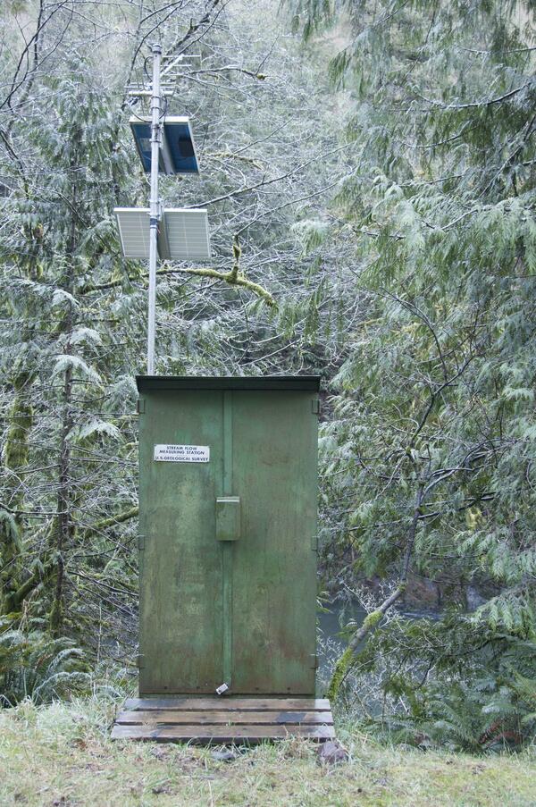
USGS streamgage on the Trask River
Trask River stage, discharge, and water-quality data are collected and used together to help monitor the current health of the river. Instream equipment is stored in protective housing to protect it from the elements. Data from the river are sent to equipment in the gage house, where it is stored then transmitted to USGS servers.
Trask River stage, discharge, and water-quality data are collected and used together to help monitor the current health of the river. Instream equipment is stored in protective housing to protect it from the elements. Data from the river are sent to equipment in the gage house, where it is stored then transmitted to USGS servers.

Newberry Volcano's Youngest Lava Flows
Newberry Volcano's youngest lava flows. Source: Robinson, J.E., Donnelly-Nolan, J.M., and Jensen, R.A., 2015, Newberry Volcano’s Youngest Lava Flows: U.S. Geological Survey Scientific Investigations Map 3329, 1 sheet, https://dx.doi.org/10.3133/sim3329.
Newberry Volcano's youngest lava flows. Source: Robinson, J.E., Donnelly-Nolan, J.M., and Jensen, R.A., 2015, Newberry Volcano’s Youngest Lava Flows: U.S. Geological Survey Scientific Investigations Map 3329, 1 sheet, https://dx.doi.org/10.3133/sim3329.

Bathymetry data of Columbia River mouth
Bathymetry data of Columbia River mouth, derived from an interferometric swath bathymetry systems survey in 2013. A) Swath map of data; B-E) sample detail pull-outs
Bathymetry data of Columbia River mouth, derived from an interferometric swath bathymetry systems survey in 2013. A) Swath map of data; B-E) sample detail pull-outs

USGS Streamgage on the Williamson River
A U.S. Geological Survey hydrologist collects a water sample from the Williamson River below Chiloquin, Oregon. The sample was analyzed as part of a water-quality study the USGS conducted in cooperation with the U.S. Bureau of Reclamation and the Klamath Tribes.
A U.S. Geological Survey hydrologist collects a water sample from the Williamson River below Chiloquin, Oregon. The sample was analyzed as part of a water-quality study the USGS conducted in cooperation with the U.S. Bureau of Reclamation and the Klamath Tribes.

USGS Cascades Volcano Observatory scientist finishes work at monitoring station KWBU at Newberry volcano
USGS Cascades Volcano Observatory scientist finishes work at monitoring station KWBU at Newberry volcanoUSGS Cascades Volcano Observatory scientist Ben Pauk finishes his notes and completes work at volcano monitoring station KWBU at Newberry volcano in central Oregon.

USGS geologist viewing the northeastern slope of Mount Hood from Shellrock monitoring station.

Views from Siuslaw National Forest, OR
Scenic view from Siuslaw National Forest, OR.

Stuck in the muck at West Fork Palmer Creek, OR
USGS scientist completing a stream assessement of West Fork Palmer Creek, Oregon.
USGS scientist completing a stream assessement of West Fork Palmer Creek, Oregon.

Tools of the trade
Photograph of field gear and equipment used in water quality monitoring.
Photograph of field gear and equipment used in water quality monitoring.

Douglas-fir trees topped to create snags for wildlife habitat
Douglas-fir trees topped to create snags for wildlife habitatSnags provide habitat for a wide range of organisms from cavity-nesting birds to insects, and are critical for maintaining forest biodiversity. Resource managers can create snags by topping trees to mitigate loss of snags to timber harvest, but information regarding changes in habitat for snag-dependent wildlife over time as created snags decay is lacking.

Hydrologist in the field
USGS hydrologist working in the field.
USGS hydrologist working in the field.

Fish biologist with a female Lost River sucker
Fish biologist with a female Lost River sucker from Sucker Springs on Upper Klamath Lake.
Fish biologist with a female Lost River sucker from Sucker Springs on Upper Klamath Lake.

Processing a Lost River sucker
Researcher processing a Lost River sucker at Sucker Springs on Upper Klamath Lake.
Researcher processing a Lost River sucker at Sucker Springs on Upper Klamath Lake.

Columbia River in Portland, OR, with Mt. Hood
The Columbia River flows by the highway on its way to the Pacific Ocean.
The Columbia River flows by the highway on its way to the Pacific Ocean.
A USGS streamflow gaging station is used to collect water data
A USGS streamflow gaging station is used to collect water dataA U.S. Geological Survey streamflow gaging station collects water data on the Trask River. The Trask River gage is located near Tillamook, Ore. and has been in operation for 17 years.

USGS streamgage on the Trask River
Trask River stage, discharge, and water-quality data are collected and used together to help monitor the current health of the river. Data from the river are sent to equipment in the gage house, where it is stored then transmitted to USGS servers.
Trask River stage, discharge, and water-quality data are collected and used together to help monitor the current health of the river. Data from the river are sent to equipment in the gage house, where it is stored then transmitted to USGS servers.

Pend Oreille River in winter
The Kalispel Tribe in northeastern Washington is located along the Pend Oreille River, home to culturally important, cold-water fish, such as bull trout and cutthroat trout.
The Kalispel Tribe in northeastern Washington is located along the Pend Oreille River, home to culturally important, cold-water fish, such as bull trout and cutthroat trout.

Upper Whitehorse Creek stream water runs underground
Upper Whitehorse Creek stream water runs undergroundA crew surveys Upper Whitehorse Creek in SE Oregon and finds a stretch of stream that dries up, or runs underground.
Upper Whitehorse Creek stream water runs underground
Upper Whitehorse Creek stream water runs undergroundA crew surveys Upper Whitehorse Creek in SE Oregon and finds a stretch of stream that dries up, or runs underground.

Installation of two 20' PIT tag antennas
Installation of two 20' PIT tag antennas. Antennas are used to monitor movements of Lost River and shortnose suckers and Redband trout through the Klamath Basin.
Installation of two 20' PIT tag antennas. Antennas are used to monitor movements of Lost River and shortnose suckers and Redband trout through the Klamath Basin.