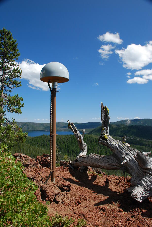
U.S. flag

An official website of the United States government

Images

Images intro.
Filter Total Items: 246
Aerial view of lakes and cinder cone at Newberry Volcano Caldera.

A view looking northeast across the central caldera of Newberry Volcano.  Paulina Lake is in the foreground and East Lake is in the distance.  The Central Pumice Cone lies between the two lakes. Near the bottom of the photo at the south edge of Paulina Lake, the two hills are named the Lakeshore Domes.

A view looking northeast across the central caldera of Newberry Volcano.  Paulina Lake is in the foreground and East Lake is in the distance.  The Central Pumice Cone lies between the two lakes. Near the bottom of the photo at the south edge of Paulina Lake, the two hills are named the Lakeshore Domes.

mount hood
Mount Hood, OR
Mount Hood, OR
Mount Hood, OR

View of Mount Hood from Pittock Mansion, Portland, OR.

View of Mount Hood from Pittock Mansion, Portland, OR.

muddy Willamette River
Willamette River through downtown Portland, OR
Image: Rogue River, Oregon
Rogue River, Oregon
Rogue River, Oregon
Rogue River, Oregon

Rogue River Canyon in southwest Oregon

Upper Klamath Lake cyanobacteria bloom

The green water, caused by massive blooms of Aphanizomenon flos-aquae, as seen in the wake of a boat, is a common sight each summer on Upper Klamath Lake, Oregon. USGS studies how these blooms effect endangered Lost River and shortnose suckers in the lake.

The green water, caused by massive blooms of Aphanizomenon flos-aquae, as seen in the wake of a boat, is a common sight each summer on Upper Klamath Lake, Oregon. USGS studies how these blooms effect endangered Lost River and shortnose suckers in the lake.

Image of the hillside and where each station is set up there at Knife Ridge
Knife Ridge station locations

Oblique photograph of Knife Ridge monitoring site showing approximate soil pit locations.

An older man and woman standing in front of a rock outcrop with a lake and forested volcano in the background. Both are wearing khaki shirts, sunglasses, and hand lenses.
Judy Fierstein and Wes Hildreth at South Sister volcano, Oregon, 2009

Wes Hildreth and Judy Fierstein, seen here in 2009 on the east shore of Sparks Lake near Oregon's South Sister volcano, were longtime field and research partners Their work showed how mapping and understanding geologic field relationships provide an unequaled framework for interpretation of laboratory-generated data; and how well-honed curiosity, acute observat

Wes Hildreth and Judy Fierstein, seen here in 2009 on the east shore of Sparks Lake near Oregon's South Sister volcano, were longtime field and research partners Their work showed how mapping and understanding geologic field relationships provide an unequaled framework for interpretation of laboratory-generated data; and how well-honed curiosity, acute observat

Rough skinned newt in defensive posture
Rough skinned newt in defensive posture, EPA ponds, Corvallis, OR

Rough-skinned newt in defensive posture, EPA ponds, Corvallis, OR. Rough-skinned newts produce a powerful neurotoxin as a defense against predators. 

Adult Oregon spotted frog

Adult Oregon spotted frog at Dilman Meadows, near Wickiup Reservoir, OR

Picture of a pine forest with a dirt road in Oregon
A pine forest with a dirt road running through it in Oregon

A pine forest with a dirt road running through it in Oregon. Photo taken as a part of field work during the Land Cover Trends project.

Broken Top volcano, inactive since 150 ka or longer, viewed to the ...
Broken Top volcano, inactive since 150 ka or longer, viewed to NW. ...

Radially dipping strata of the cone include subequal proportions of lava flows and flow breccias and of proximal agglutinate and scoria falls, nearly all having 54 to 56 percent SiO2. Numerous mafic dikes and sills intrude the cone, and an apron of compositionally similar mafic lavas extends far outward from the cone.

Radially dipping strata of the cone include subequal proportions of lava flows and flow breccias and of proximal agglutinate and scoria falls, nearly all having 54 to 56 percent SiO2. Numerous mafic dikes and sills intrude the cone, and an apron of compositionally similar mafic lavas extends far outward from the cone.

Crooked River at Smith Rocks

Crooked River of the Deschutes River Basin, Oregon, flows through Smith Rocks 

Crooked River of the Deschutes River Basin, Oregon, flows through Smith Rocks 

Controlled burn at Hart Mountain National Wildlife Refuge.

Wildfire is one of the largest sources of re-released mercury to the atmosphere and a component to the widespread movement of inorganic mercury to aquatic sediments.

Downloading data in flood
Downloading data during a flood on the Williamson River

Researcher from Klamath Falls Field Station downloading data during a flood on the Williamson River Oregon.

Mount Jefferson (pointed peak in middle) and Three Sisters (to the ...
Mount Jefferson (pointed peak in middle) and Three Sisters (to righ...

Mount Jefferson (pointed peak in middle) and Three Sisters (to the right) in Oregon, south-facing aerial view as seen from Mount St. Helens.

Global Positioning System receiver (dome on pole) and seismometer

Global Positioning System receiver (dome on pole) and seismometer (box on ground in distance) at a volcano monitoring station for Three Sisters in Central Oregon. Solar panel mounted to pole.

Global Positioning System receiver (dome on pole) and seismometer (box on ground in distance) at a volcano monitoring station for Three Sisters in Central Oregon. Solar panel mounted to pole.

Was this page helpful?