
As blooms of cyanobacteria die on the water surface of Upper Klamath Lake they turn blue-green.
Images
Images intro.
Filter Total Items: 250

Howard Bay - blooms of cyanobacteria
As blooms of cyanobacteria die on the water surface of Upper Klamath Lake they turn blue-green.

In-lake mesocosms in Upper Klamath Lake, OR
USGS studies the behavior and health of juvenile endangered Lost River and shortnose suckers within in-lake mesocosms in Upper Klamath Lake, Oregon.
USGS studies the behavior and health of juvenile endangered Lost River and shortnose suckers within in-lake mesocosms in Upper Klamath Lake, Oregon.

Columbia River mouth bathymetry
Columbia River mouth bathymetry from USGS data release
Columbia River mouth bathymetry from USGS data release

Red alder landscape
Looking out over a red alder forest with evergreen trees at Cascade Head Preserve in Oregon.
Looking out over a red alder forest with evergreen trees at Cascade Head Preserve in Oregon.
Sediment trap deployment in Hells Canyon Reservoir in the Snake River on the Idaho-Oregon border
Sediment trap deployment in Hells Canyon Reservoir in the Snake River on the Idaho-Oregon borderUSGS scientist conducts sediment trap deployment in Hells Canyon Reservoir in the Snake River on the Idaho-Oregon border.

Remote passive integrated transponder (PIT) detection system
Remote passive integrated transponder (PIT) detection systemKlamath Falls Field Station staff maintain remote Passive Integrated Transponder (PIT) detection system on Upper Klamath Lake, Oregon.
Remote passive integrated transponder (PIT) detection system
Remote passive integrated transponder (PIT) detection systemKlamath Falls Field Station staff maintain remote Passive Integrated Transponder (PIT) detection system on Upper Klamath Lake, Oregon.

Crossing the Idaho-Oregon border in winter
This remote area along the southern Idaho-Oregon border was affected by the 2015 Soda Fire, which burned nearly 400 square miles of sagebrush habitat important to many species of wildlife, as well as federal and private ranchlands.
This remote area along the southern Idaho-Oregon border was affected by the 2015 Soda Fire, which burned nearly 400 square miles of sagebrush habitat important to many species of wildlife, as well as federal and private ranchlands.

GeoGirls hike onto the Pumice Plain and learn about Mount St. Helens
GeoGirls hike onto the Pumice Plain and learn about Mount St. HelensGeoGirls hike onto the Pumice Plain to learn more about Mount St. Helens’ historical
eruptions.
GeoGirls hike onto the Pumice Plain and learn about Mount St. Helens
GeoGirls hike onto the Pumice Plain and learn about Mount St. HelensGeoGirls hike onto the Pumice Plain to learn more about Mount St. Helens’ historical
eruptions.

Digital Elevation Model for Newberry Volcano and vicinity.
Digital Elevation Model for Newberry Volcano and vicinity.High-resolution digital elevation dataset for Newberry Volcano and vicinity, Oregon, based on lidar survey of August-September, 2010 and bathymetric survey of June, 2001.
Digital Elevation Model for Newberry Volcano and vicinity.
Digital Elevation Model for Newberry Volcano and vicinity.High-resolution digital elevation dataset for Newberry Volcano and vicinity, Oregon, based on lidar survey of August-September, 2010 and bathymetric survey of June, 2001.

Geogirls use computers in the field to track locations
Geogirls use computers in the field to track locationsGeogirls use computers in the field to track locations and annotate field photos.
Geogirls use computers in the field to track locations
Geogirls use computers in the field to track locationsGeogirls use computers in the field to track locations and annotate field photos.

GeoGirls learn about the eruption of Mount St. Helens
GeoGirls learn about the eruption of Mount St. HelensGeoGirls learn about how the May 18, 1980 eruption of Mount St. Helens impacted the ecology of the area.
GeoGirls learn about the eruption of Mount St. Helens
GeoGirls learn about the eruption of Mount St. HelensGeoGirls learn about how the May 18, 1980 eruption of Mount St. Helens impacted the ecology of the area.

Using radio telemetry
Don Ashton uses radio telemetry to track a federally threatened Oregon spotted frog (Rana pretiosa). Data provide information on resource use, movement patterns, and overwintering
Don Ashton uses radio telemetry to track a federally threatened Oregon spotted frog (Rana pretiosa). Data provide information on resource use, movement patterns, and overwintering

Looking Down From the Top of Detroit Dam
North Santiam River Valley downstream of Detroit Dam, as viewed from the top of Detroit Dam.
North Santiam River Valley downstream of Detroit Dam, as viewed from the top of Detroit Dam.

Fishing Zollner Creek, OR
USGS team of scientists electro-shocking (fishing) Zollner Creek, OR.
USGS team of scientists electro-shocking (fishing) Zollner Creek, OR.

Paulina Lake, in the caldera of Newberry Volcano. Photographed fro...
Paulina Lake, in the caldera of Newberry Volcano. Photographed fro...Paulina Lake, in the caldera of Newberry Volcano. View looking south-southeast.
Paulina Lake, in the caldera of Newberry Volcano. Photographed fro...
Paulina Lake, in the caldera of Newberry Volcano. Photographed fro...Paulina Lake, in the caldera of Newberry Volcano. View looking south-southeast.

Adult and juvenile beaver near Windrose, Oregon
Adult and juvenile beaver near Windrose, Oregon
Adult and juvenile beaver near Windrose, Oregon

Beaver along bank of pond in Tualatin River Basin, OR
Beaver along bank of pond in Tualatin River Basin, ORBeaver along bank of pond in Tualatin River Basin, OR
Beaver along bank of pond in Tualatin River Basin, OR
Beaver along bank of pond in Tualatin River Basin, ORBeaver along bank of pond in Tualatin River Basin, OR

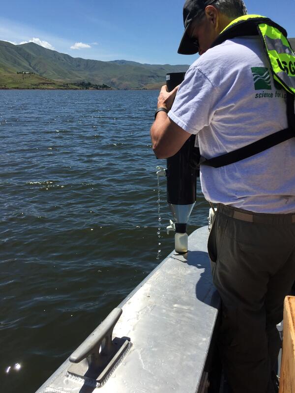
Sampling water in Klamath Lake
USGS scientist sampling water in Klamath Lake.
USGS scientist sampling water in Klamath Lake.

USGS - NOROCK Research team in the Northern Cascades.
USGS - NOROCK Research team in the Northern Cascades.USGS - NOROCK field team in the Northern Cascades studying Hoary marmots and American pika and snowpack dynamics.
USGS - NOROCK Research team in the Northern Cascades.
USGS - NOROCK Research team in the Northern Cascades.USGS - NOROCK field team in the Northern Cascades studying Hoary marmots and American pika and snowpack dynamics.

Beaver at Summer Lake, Oregon
Beaver swimming in Summer Lake, Oregon.
Beaver swimming in Summer Lake, Oregon.

Crater Lake Image Shows Potential of Sentinel-2A
This image from the European Space Agency's Sentinel-2A satellite offers a breathtaking view of Crater Lake National Park in southern Oregon. It offers something equally important to park managers, scientists, and anyone else interested in land cover change—a view that is highly similar and complementary to Landsat acquisitions.
This image from the European Space Agency's Sentinel-2A satellite offers a breathtaking view of Crater Lake National Park in southern Oregon. It offers something equally important to park managers, scientists, and anyone else interested in land cover change—a view that is highly similar and complementary to Landsat acquisitions.