Dragonfly Mercury Project specimen collection in Glacier NP
Dragonfly Mercury Project specimen collection in Glacier NPResearchers instruct volunteers on how to collect dragonfly larvae in Glacier NP as a part of the Dragonfly Mercury Project.

Official websites use .gov
A .gov website belongs to an official government organization in the United States.
Secure .gov websites use HTTPS
A lock () or https:// means you’ve safely connected to the .gov website. Share sensitive information only on official, secure websites.
Check out USGS images, video, and audio files from across Region 4.

Researchers instruct volunteers on how to collect dragonfly larvae in Glacier NP as a part of the Dragonfly Mercury Project.
Researchers instruct volunteers on how to collect dragonfly larvae in Glacier NP as a part of the Dragonfly Mercury Project.
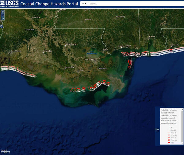
This Coastal Change Storm Hazard Team map was created Friday, July 12, 2019 and shows forecast beach erosion (the strip of colored bars closest to the coast), overwash (middle strip) and inundation (outer strip) effects of Tropical Storm Barry’s predicted landfall in Louisiana.
This Coastal Change Storm Hazard Team map was created Friday, July 12, 2019 and shows forecast beach erosion (the strip of colored bars closest to the coast), overwash (middle strip) and inundation (outer strip) effects of Tropical Storm Barry’s predicted landfall in Louisiana.
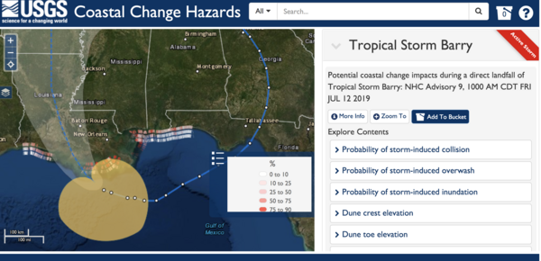
This Coastal Change Storm Hazard Team map was created Friday, July 12, 2019 and shows forecast beach erosion (the strip of colored bars closest to the coast), overwash (middle strip) and inundation (outer strip) effects of Tropical Storm Barry’s predicted landfall in Louisiana.
This Coastal Change Storm Hazard Team map was created Friday, July 12, 2019 and shows forecast beach erosion (the strip of colored bars closest to the coast), overwash (middle strip) and inundation (outer strip) effects of Tropical Storm Barry’s predicted landfall in Louisiana.

USGS technician Chris Broz helps take water measurements on the Big Sioux River during record flooding in March, 2019.
USGS technician Chris Broz helps take water measurements on the Big Sioux River during record flooding in March, 2019.

After record flooding on the Big Sioux River, USGS crews mobilized to take important water measurements.
After record flooding on the Big Sioux River, USGS crews mobilized to take important water measurements.

After record flooding on the Big Sioux River, USGS crews mobilized to take important water measurements.
After record flooding on the Big Sioux River, USGS crews mobilized to take important water measurements.

In this video segment, Physical Scientists from the U.S. Geological Survey (USGS) Lower Mississippi Gulf Water Science Center (LMGWSC) give an overview of USGS monitoring efforts along the Lower Mississippi River. General sampling logistics and monitoring frequencies are also shown.
In this video segment, Physical Scientists from the U.S. Geological Survey (USGS) Lower Mississippi Gulf Water Science Center (LMGWSC) give an overview of USGS monitoring efforts along the Lower Mississippi River. General sampling logistics and monitoring frequencies are also shown.

Mississippi leads the U.S. in catfish production. The blue tinted shapes in these Landsat images mark ponds where catfish are raised.
Mississippi leads the U.S. in catfish production. The blue tinted shapes in these Landsat images mark ponds where catfish are raised.

Climate change is predicted to alter sport fish communities in Midwestern lakes, but managers currently have limited information on individual lakes that can be used to set local expectations or intervene with mitigation strategies.
Climate change is predicted to alter sport fish communities in Midwestern lakes, but managers currently have limited information on individual lakes that can be used to set local expectations or intervene with mitigation strategies.

A USGS crew used new drone technology to test and evaluate new technology to measure water speed from the air without touching the water. This drone footage was taken on the Missouri River at Hermann, Missouri on March 27, 2019. Scientists compared these new method results to the conventional way of taking measurements from a boat.
A USGS crew used new drone technology to test and evaluate new technology to measure water speed from the air without touching the water. This drone footage was taken on the Missouri River at Hermann, Missouri on March 27, 2019. Scientists compared these new method results to the conventional way of taking measurements from a boat.

An important conservation strategy for climate change is to enhance and maintain regional habitat connectivity for the long-term viability of wildlife populations. Modeling habitat connectivity for wildlife species often results in a mapped network of linkages between habitat patches.
An important conservation strategy for climate change is to enhance and maintain regional habitat connectivity for the long-term viability of wildlife populations. Modeling habitat connectivity for wildlife species often results in a mapped network of linkages between habitat patches.
Waterfowl populations in the northern Gulf of Mexico (NGOM) rely extensively on plants that grow under the surface in shallow waters, know as submerged aquatic vegetation (SAV), as a critical food resource in the winter season.
Waterfowl populations in the northern Gulf of Mexico (NGOM) rely extensively on plants that grow under the surface in shallow waters, know as submerged aquatic vegetation (SAV), as a critical food resource in the winter season.
The USGS Ecosystems Mission Area brings you Outstanding in the Field, a series of stories about our science, our adventures, and our efforts to better understand our fish and wildlife and the ecosystems that support them. In this episode we describe the USGS’s efforts to track frog populations in the southeast United States.
The USGS Ecosystems Mission Area brings you Outstanding in the Field, a series of stories about our science, our adventures, and our efforts to better understand our fish and wildlife and the ecosystems that support them. In this episode we describe the USGS’s efforts to track frog populations in the southeast United States.
2011 had been predicted to be a particularly bad year for flooding in the northern Plains and upper Midwest. Areas along the Red River in North Dakota and Minnesota and the James Rivers in the Dakotas are still experiencing flooding from snowmelt. Now extreme rainfall is causing severe flooding along the Mississippi and Ohio Rivers.
2011 had been predicted to be a particularly bad year for flooding in the northern Plains and upper Midwest. Areas along the Red River in North Dakota and Minnesota and the James Rivers in the Dakotas are still experiencing flooding from snowmelt. Now extreme rainfall is causing severe flooding along the Mississippi and Ohio Rivers.
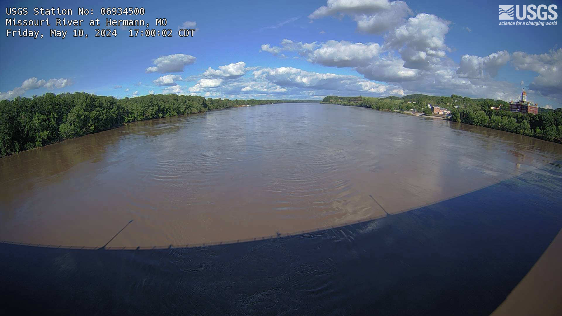
The webcam is located on a gaging station (06934500) on the Missouri River in Hermann, MO. View the current conditions at the gaging station.
The webcam is located on a gaging station (06934500) on the Missouri River in Hermann, MO. View the current conditions at the gaging station.

