
USGS Science Collaboration Portal for the Colorado River Basin
Collaboration platform that brings together science, data, and mapping and analytical tools from across the basin
Collaboration platform that brings together science, data, and mapping and analytical tools from across the basin
Colorado River Basin Actionable and Strategic Integrated Science and Technology (ASIST) Initiative
Fostering Innovative Interdisciplinary Science for Characterizing and Adapting to Long-term Drought
Fostering Innovative Interdisciplinary Science for Characterizing and Adapting to Long-term Drought
Colorado River Basin Drought and the 2023 Water Year
Geonarrative presentation comparing 2023 conditions to the long-term drought in the Colorado River Basin
Geonarrative presentation comparing 2023 conditions to the long-term drought in the Colorado River Basin
Great Salt Lake Data and Reports by the USGS
Learn about Water Quantity and Quality and Aquatic Ecology of this National Treasure
Learn about Water Quantity and Quality and Aquatic Ecology of this National Treasure
Colorado River Basin Studies in Utah
Learn about Surface Water, Groundwater Quantities and Quality and Artificial Recharge of Groundwater in the Colorado River Basin in Utah
Learn about Surface Water, Groundwater Quantities and Quality and Artificial Recharge of Groundwater in the Colorado River Basin in Utah
Streamflow in the Upper Rio Grande Basin
USGS Analyses of the Effects of Potential Future Climate Conditions on Streamflows in the Upper Rio Grande Basin
USGS Analyses of the Effects of Potential Future Climate Conditions on Streamflows in the Upper Rio Grande Basin
Next Generation Water Observing System (NGWOS) Study: Upper Colorado River Basin
The USGS NGWOS Program Provides Innovative, High-fidelity, Real-time Data and Insightful Analyses about Water Quantity, Quality, and Use in Selected Watersheds across the U.S.
The USGS NGWOS Program Provides Innovative, High-fidelity, Real-time Data and Insightful Analyses about Water Quantity, Quality, and Use in Selected Watersheds across the U.S.
Rocky Mountain Region
USGS Region 7 Staff support and advise USGS Science Centers that provide numerous stakeholders with vital information about spatial distribution and temporal trends in critical minerals, energy resources, geology, water resources, native plants and wildlife, and hazards posed by earthquakes and landslides in Colorado, New Mexico, Utah, Wyoming and beyond.
USGS Region 7: Upper Colorado Basin (Rocky Mountain)
USGS Region 7: Upper Colorado Basin (Rocky Mountain)

Map Showing USGS/DOI Unified Region 7 and adjoining Regions
Key USGS Region 7 Contacts
Key USGS Region 7 Contacts
Additional Information about USGS Region 7
Additional Information about USGS Region 7
News
FORT Updates: From Plains to Peaks - Vol. 4 | Issue 1
FORT Updates: From Plains to Peaks - Vol. 4 | Issue 1
New tree-ring science demonstrates successful restoration of historical fire patterns in two southwestern wilderness areas
New tree-ring science demonstrates successful restoration of historical fire patterns in two southwestern wilderness areas
New tools for a growing threat: Co-developed science informs the fight against invasive grasses in the sagebrush biome
New tools for a growing threat: Co-developed science informs the fight against invasive grasses in the sagebrush biome
Publications
Sampling and analysis plan for the water-quality monitoring program in Lake Koocanusa and upper Kootenai River, Montana, water years 2022–23 Sampling and analysis plan for the water-quality monitoring program in Lake Koocanusa and upper Kootenai River, Montana, water years 2022–23
The U.S. Geological Survey, in cooperation with the U.S. Environmental Protection Agency, collected water-quality samples and environmental data in Lake Koocanusa (also known as “Koocanusa Reservoir”), the Kootenai River, and the Tobacco River during water years 2022–23. The transboundary Lake Koocanusa is in southeastern British Columbia, Canada, and northwestern Montana, United States...
Valuing socio-economic and ecological attributes of forested watershed restoration to reduce wildfire risk in the southwestern U.S. Valuing socio-economic and ecological attributes of forested watershed restoration to reduce wildfire risk in the southwestern U.S.
Forest restoration in a watershed can provide numerous ecological improvements and social benefits, including reducing the risk of extreme wildfire. Understanding the values of the accrued benefits can be used to evaluate the use of funds to support restoration. The Rio Grande watershed is a vast watershed covering approximately 335,000 mile2 (867,646 km2). The Rio Grande watershed...
Utilization of multiple geochronology techniques to constrain the age of laterization and mineralization of the world-class Mount Weld rare earth element deposit, Western Australia Utilization of multiple geochronology techniques to constrain the age of laterization and mineralization of the world-class Mount Weld rare earth element deposit, Western Australia
Pervasive chemical weathering on stable cratons may form thick regoliths and elemental enrichment, but constraining the age of regolith formation is challenging. In this study we utilize multiple geochronological techniques on different minerals from the world-class Mount Weld rare earth element (REE) deposit, formed by lateritic weathering of a carbonatite, to constrain the age of...
Science
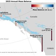
2025 USGS Benchmark Glaciers Executive Summary
2025 Data Now Available: Explore how the USGS Benchmark Glaciers have changed in 2025

Land Treatment Exploration Tool
The Land Treatment Exploration Tool provides a practical resource for managers who are planning restoration and rehabilitation actions on public lands. The tool generates a variety of spatial products while being user friendly for all levels of GIS expertise, even to those with little or no experience.

Gulkana Glacier
Gulkana Glacier is located in the high-latitude continental climate regime of Alaska’s Delta Mountains. Glacier observations began at this site in 1966 and continue through present as the northern most USGS Benchmark Glacier.