
Artist's depiction of NASA's Mars Reconnaissance Orbiter (MRO), orbiting above Mars. MRO entered Mars orbit in 2006.
Images
Browse here for some of our available imagery. We may get permission to use some non-USGS images and these should be marked and are subject to copyright laws. USGS Astrogeology images can be freely downloaded.
Filter Total Items: 330

Mars Reconnaissance Orbiter (MRO)
Artist's depiction of NASA's Mars Reconnaissance Orbiter (MRO), orbiting above Mars. MRO entered Mars orbit in 2006.

USGS SIM 3480: Geologic Map of the Aeolis Dorsa Region, Mars
USGS SIM 3480: Geologic Map of the Aeolis Dorsa Region, MarsUSGS SIM 3480: Geologic Map of the Aeolis Dorsa Region, Mars
By: Devon M. Burr, Robert E. Jacobsen, Alexandra Lefort, Rose M. Borden, and Samantha E. Peel
Map and associated data available from the USGS Publication Warehouse: https://doi.org/10.3133/sim3480

Sol 3324: Left Navigation Camera
This image was taken by Left Navigation Camera onboard NASA's Mars rover Curiosity on Sol 3324 (2021-12-12 14:37:35 UTC). Image Credit: NASA/JPL-Caltech
This image was taken by Left Navigation Camera onboard NASA's Mars rover Curiosity on Sol 3324 (2021-12-12 14:37:35 UTC). Image Credit: NASA/JPL-Caltech

Image taken by NASA's Curiosity Navcam Camera on Mars
Image taken by NASA's Curiosity Navcam Camera on MarsThis image was taken by Right Navigation Camera onboard NASA's Mars rover Curiosity on Sol 3285. Credit: NASA/JPL-Caltech. Download image ›
Image taken by NASA's Curiosity Navcam Camera on Mars
Image taken by NASA's Curiosity Navcam Camera on MarsThis image was taken by Right Navigation Camera onboard NASA's Mars rover Curiosity on Sol 3285. Credit: NASA/JPL-Caltech. Download image ›

Ryan Anderson
Photograph of physical scientist Ryan Anderson, taken in the San Francisco Peaks north of Flagstaff, AZ in October, 2021.
Photograph of physical scientist Ryan Anderson, taken in the San Francisco Peaks north of Flagstaff, AZ in October, 2021.

USGS SIM 3477: Geologic Map of the Athabasca Valles Region, Mars
USGS SIM 3477: Geologic Map of the Athabasca Valles Region, MarsUSGS SIM 3477: Geologic Map of the Athabasca Valles Region, Mars
By: Laszlo P. Keszthelyi, Alexandra E. Huff, and Windy L. Jaeger
Map and associated data available from the USGS Publication Warehouse: https://doi.org/10.3133/sim3477

IMG_0302.jpeg
Image showing a section of Lava River Cave, located in Northern Arizona.
Image showing a section of Lava River Cave, located in Northern Arizona.

SUCR cinder field met station.jpeg
The image shows the Astrogeology Science Center experimental meteorological station.
The image shows the Astrogeology Science Center experimental meteorological station.

Lori Pigue
Selfie of Lori Pigue atop SP Mountain, a cinder cone volcano in northern Arizona. The dark feature in the background is a lava flow that extends north from the volcano.
Selfie of Lori Pigue atop SP Mountain, a cinder cone volcano in northern Arizona. The dark feature in the background is a lava flow that extends north from the volcano.

Fortezzo et al., 2020: Unified Map of the Moon
This new work represents a seamless, globally consistent, 1:5,000,000-scale geologic map derived from the six digitally renovated geologic maps (see Source Online Linkage below).
This new work represents a seamless, globally consistent, 1:5,000,000-scale geologic map derived from the six digitally renovated geologic maps (see Source Online Linkage below).

Jezero crater, Mars
Description: This is a high-resolution oblique view of the northeastern edge of the delta deposit in Jezero crater, the landing site for the Perseverance Mars rover. In the foreground, buttes of delta material stand above the crater floor. On the left and in the middle of this image, the layered rocks of the delta deposit are visible.
Description: This is a high-resolution oblique view of the northeastern edge of the delta deposit in Jezero crater, the landing site for the Perseverance Mars rover. In the foreground, buttes of delta material stand above the crater floor. On the left and in the middle of this image, the layered rocks of the delta deposit are visible.


Moon LRO LROC WAC Global Morphology Mosaic 100 m
Moon LRO LROC WAC Global Morphology Mosaic 100 m. Image processing completed using ISIS and orthorectified on both LOLA and WAC digital elevation models.
Moon LRO LROC WAC Global Morphology Mosaic 100 m. Image processing completed using ISIS and orthorectified on both LOLA and WAC digital elevation models.

MSL SAM Sol 2639
MSL Sol 2639: SAM Image

Sols 2574-2576: Characterizing Central Butte
Sols 2574-2576: Characterizing Central Butte
Sols 2574-2576: Characterizing Central Butte
USGS Astrogeology training astronauts at Meteor Crater in Arizona
USGS Astrogeology training astronauts at Meteor Crater in ArizonaPHOTO DATE: 09-19-19 LOCATION: Flagstaff, Arizona - METEOR CRATER SUBJECT: Photographic Coverage of 2017 ASCAN Class (Group 22) Geology Training in Arizona, ASCAN GEOLOGY TRAINING DAY 4. PHOTOGRAPHER: BILL STAFFORD

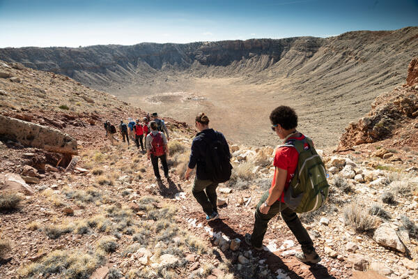
Astronauts descending into Meteor Crater in Winslow Arizona.
Astronauts descending into Meteor Crater in Winslow Arizona.Astronauts descending into Meteor Crater in Winslow Arizona. Terrestrial analogs like Meteor Crater provide excellent training grounds for planetary exploration.
Astronauts descending into Meteor Crater in Winslow Arizona.
Astronauts descending into Meteor Crater in Winslow Arizona.Astronauts descending into Meteor Crater in Winslow Arizona. Terrestrial analogs like Meteor Crater provide excellent training grounds for planetary exploration.

Astronaut Field Training in Flagstaff
USGS Field Test Support Unit (left to right) Dick Wiser, John Hendricks, Bill Tinnin and Putty Mills with the Explorer, a lunar rover vehicle simulator at Cinder Lake Crater Field east of Flagstaff, December 1968.
USGS Field Test Support Unit (left to right) Dick Wiser, John Hendricks, Bill Tinnin and Putty Mills with the Explorer, a lunar rover vehicle simulator at Cinder Lake Crater Field east of Flagstaff, December 1968.

Map of thermal areas in Yellowstone National Park, 2019
Map of thermal areas in Yellowstone National Park, 2019Map of thermal areas in Yellowstone National Park. Most of Yellowstone's more than 10,000 thermal features are clustered together into about 120 distinct thermal areas (shown in red). Lakes are blue. The Yellowstone Caldera is solid black and the resurgent domes are dotted black. Roads are yellow.

Landsat-8 nighttime thermal infrared image, Tern Lake, Yellowstone
Landsat-8 nighttime thermal infrared image, Tern Lake, YellowstoneLandsat-8 nighttime thermal infrared image from April 2017 showing the Tern Lake area. In Yellowstone, temperatures are extremely cold at night in the winter, and most lakes are frozen (dark pixels). West Tern Lake seems to be thawing here - perhaps it receives some thermal waters from nearby hot springs.

High-spatial-resolution airborne images of Tern Lake, Yellowstone
High-spatial-resolution airborne images of Tern Lake, YellowstoneHigh-spatial-resolution airborne images of the Tern Lake area from 1994, 2006, and 2017. The area of bright pixels identified in the Landsat-8 thermal infrared image corresponds to a newly emerging area of warm ground and tree kills about 32,500 m2 (8 acres, or 4 soccer fields) in area.