
Field trip to Death Valley. John Mars (USGS), Simon Hook (JPL), C.R. Souza Filho (University of Campinas), Giles Marion (Desert Research Institute)
Images
Browse here for some of our available imagery. We may get permission to use some non-USGS images and these should be marked and are subject to copyright laws. USGS Astrogeology images can be freely downloaded.
Filter Total Items: 330

Death Valley
Field trip to Death Valley. John Mars (USGS), Simon Hook (JPL), C.R. Souza Filho (University of Campinas), Giles Marion (Desert Research Institute)

Death Valley
Field trip to Death Valley. Jim Crowley (USGS), Giles Marion (Desert Research Institute), John Mars (USGS).
Field trip to Death Valley. Jim Crowley (USGS), Giles Marion (Desert Research Institute), John Mars (USGS).

Death Valley
Field trip to Death Valley. John Mars (USGS). Giles Marion (Desert Research Institute), Jim Crowley (USGS), Simon Hook (JPL).
Field trip to Death Valley. John Mars (USGS). Giles Marion (Desert Research Institute), Jim Crowley (USGS), Simon Hook (JPL).

Arid Soils
Jim Crowley taking spectral measurements of arid soil with a field spectrometer.
Jim Crowley taking spectral measurements of arid soil with a field spectrometer.

Enceladus Cassini ISS Narrow Angle Color Mosaic
As it swooped past the south pole of Saturn's moon Enceladus on July 14, 2005, Cassini acquired high resolution views of this puzzling ice world. From afar, Enceladus exhibits a bizarre mixture of softened craters and complex, fractured terrains.
As it swooped past the south pole of Saturn's moon Enceladus on July 14, 2005, Cassini acquired high resolution views of this puzzling ice world. From afar, Enceladus exhibits a bizarre mixture of softened craters and complex, fractured terrains.

Sphere-like grains found on Mars, nicknamed "Blueberries"
Sphere-like grains found on Mars, nicknamed "Blueberries"Photo taken by Opportunity of Sphere-like grains nicknamed "Blueberries", due to their shape. Photo is a mosaic of PANCAM and MI instruments.
Sphere-like grains found on Mars, nicknamed "Blueberries"
Sphere-like grains found on Mars, nicknamed "Blueberries"Photo taken by Opportunity of Sphere-like grains nicknamed "Blueberries", due to their shape. Photo is a mosaic of PANCAM and MI instruments.

Uranus's Ring
Infrared composite image of Uranus taken by the Keck Telescope.
Infrared composite image of Uranus taken by the Keck Telescope.

USGS IMAP 2693: Geologic map of the MTM 25047 and 20047 quadrangles, central Chryse Planitia/Viking 1 Lander site, Mars
USGS IMAP 2693: Geologic map of the MTM 25047 and 20047 quadrangles, central Chryse Planitia/Viking 1 Lander site, MarsUSGS IMAP 2693: Geologic map of the MTM 25047 and 20047 quadrangles, central Chryse Planitia/Viking 1 Lander site, Mars
By: L.S. Crumpler, R. A. Craddock, and J.C. Aubele
Map and associated documents are available from the USGS Publications Warehouse: https://doi.org/10.3133/i2693

MGS MOLA Global Colorized Hillshade
This map is based on data from the Mars Orbiter Laser Altimeter (MOLA; Smith and others, 2001), an instrument on NASA’s Mars Global Surveyor (MGS) spacecraft (Albee and others, 2001).
This map is based on data from the Mars Orbiter Laser Altimeter (MOLA; Smith and others, 2001), an instrument on NASA’s Mars Global Surveyor (MGS) spacecraft (Albee and others, 2001).

Callisto Galileo SSI Color Mosaic
Bright scars on a darker surface testify to a long history of impacts on Jupiter's moon Callisto in this image of Callisto from NASA's Galileo spacecraft.
Bright scars on a darker surface testify to a long history of impacts on Jupiter's moon Callisto in this image of Callisto from NASA's Galileo spacecraft.

Venus Magellan Color Topography
The hemispheric view of Venus, as revealed by more than a decade of radar investigations culminating in the 1990-1994 Magellan mission, is centered at 180 degrees east longitude. The Magellan spacecraft imaged more than 98% of Venus at a resolution of about 100 meters; the effective resolution of this image is about 3 km.
The hemispheric view of Venus, as revealed by more than a decade of radar investigations culminating in the 1990-1994 Magellan mission, is centered at 180 degrees east longitude. The Magellan spacecraft imaged more than 98% of Venus at a resolution of about 100 meters; the effective resolution of this image is about 3 km.

Triton Voyager Color Mosaic
Global color mosaic of Triton, taken in 1989 by Voyager 2 during its flyby of the Neptune system. Color was synthesized by combining high-resolution images taken through orange, violet, and ultraviolet filters; these images were displayed as red, green, and blue images and combined to create this color version.
Global color mosaic of Triton, taken in 1989 by Voyager 2 during its flyby of the Neptune system. Color was synthesized by combining high-resolution images taken through orange, violet, and ultraviolet filters; these images were displayed as red, green, and blue images and combined to create this color version.

USGS IMAP 2581: Geologic Map of Callisto
USGS IMAP 2581: Geologic map of Callisto
By K.C. Bender, J. W. Rice Jr., D.E. Wilhems, and Ronald Greeley
Map and associated documents available from the USGS Publications Warehouse: https://doi.org/10.3133/i2581
USGS IMAP 2581: Geologic map of Callisto
By K.C. Bender, J. W. Rice Jr., D.E. Wilhems, and Ronald Greeley
Map and associated documents available from the USGS Publications Warehouse: https://doi.org/10.3133/i2581

Io Galileo SSI Color Mosaic
Io, the most volcanic body in the solar system is seen in the highest resolution obtained to date by NASA's Galileo spacecraft. The smallest features that can be discerned are 2.5 kilometers in size. There are rugged mountains several kilometers high, layered materials forming plateaus, and many irregular depressions called volcanic calderas.
Io, the most volcanic body in the solar system is seen in the highest resolution obtained to date by NASA's Galileo spacecraft. The smallest features that can be discerned are 2.5 kilometers in size. There are rugged mountains several kilometers high, layered materials forming plateaus, and many irregular depressions called volcanic calderas.

A'a' Channel
Detail of levee on an active channelized aa flow. Note the pahoehoe overflows in the levees and the level of the active flow below the tops of the levees. This lower flow level is not allowed in the commonly used "Bingham" model of lava flows.
Detail of levee on an active channelized aa flow. Note the pahoehoe overflows in the levees and the level of the active flow below the tops of the levees. This lower flow level is not allowed in the commonly used "Bingham" model of lava flows.

Section of Burst Tumulus
A section of burst tumulus that has fallen away from the larger structure. Tumuli can burst when the influx of lava is rapid compared to the rate at which the crust is thickening by cooling. In these cases the pressure driving the lava is significantly greater than the weight of the overlying crust.
A section of burst tumulus that has fallen away from the larger structure. Tumuli can burst when the influx of lava is rapid compared to the rate at which the crust is thickening by cooling. In these cases the pressure driving the lava is significantly greater than the weight of the overlying crust.

A'a' Channel
An a'a' channel near the Royal Gardens subdivision on Kilauea Volcano, Hawaii. The flows in the background are from the 1980s. Note that the flow level is below the levees and the pahoehoe overflows emplaced on top of the a'a'.
An a'a' channel near the Royal Gardens subdivision on Kilauea Volcano, Hawaii. The flows in the background are from the 1980s. Note that the flow level is below the levees and the pahoehoe overflows emplaced on top of the a'a'.
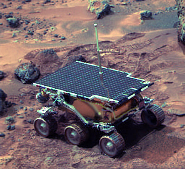
Sojourner_on_Mars.jpg
Image of Sojourner, paving the way for future, more sophisticated, rovers to study Mars and other planetary bodies.
Image of Sojourner, paving the way for future, more sophisticated, rovers to study Mars and other planetary bodies.

Pu’u ‘Ō’ō
Pu’u ‘Ō’ō is a cinder and spatter cone in Kilauea’s east rift zone. It began erupting on January 3, 1983; a summary of its eruption can be found here. This image shows the result of the largest of the collapse pits that began to appear around 1993.
Pu’u ‘Ō’ō is a cinder and spatter cone in Kilauea’s east rift zone. It began erupting on January 3, 1983; a summary of its eruption can be found here. This image shows the result of the largest of the collapse pits that began to appear around 1993.

Europa Galileo SSI Natural Color Mosaic
This image shows two views of the trailing hemisphere of Jupiter's ice-covered satellite, Europa. The left image shows the approximate natural color appearance of Europa. The image on the right is a false-color composite version combining violet, green and infrared images to enhance color differences in the predominantly water-ice crust of Europa.
This image shows two views of the trailing hemisphere of Jupiter's ice-covered satellite, Europa. The left image shows the approximate natural color appearance of Europa. The image on the right is a false-color composite version combining violet, green and infrared images to enhance color differences in the predominantly water-ice crust of Europa.

Ganymede Galileo SSI Natural Color Mosaic
Natural color view of Ganymede from the Galileo spacecraft during its first encounter with the satellite. North is to the top of the picture and the sun illuminates the surface from the right. The dark areas are the older, more heavily cratered regions and the light areas are younger, tectonically deformed regions.
Natural color view of Ganymede from the Galileo spacecraft during its first encounter with the satellite. North is to the top of the picture and the sun illuminates the surface from the right. The dark areas are the older, more heavily cratered regions and the light areas are younger, tectonically deformed regions.