
Data
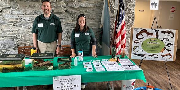
At the Eastern Ecological Science Center (EESC), we strive to provide world-class science to inform natural resource decisions that preserve and enhance our quality of life.
Connect with Us
Connect with Us
Find locations, staff profiles and contact information for our team.
EESC's Latest Findings
EESC's Latest Findings
Search for EESC publications by location, author, year or keyword.
Filter Total Items: 310
SNP data for Karner blue butterfly samples from across the species range SNP data for Karner blue butterfly samples from across the species range
This dataset contains sample information about the origin of the butterflies sequenced, and their corresponding SNP genotype data. These data were used to examine patterns of genomic structure of the Karner blue butterfly from throughout its range. The raw sequence data are archived in the GenBank Bioproject PRJNA995790 at: https://www.ncbi.nlm.nih.gov/bioproject/
Data describing highly pathogenic H5N1 in Double-crested Cormorants of the Chesapeake Bay (ver. 2.0, December 2024) Data describing highly pathogenic H5N1 in Double-crested Cormorants of the Chesapeake Bay (ver. 2.0, December 2024)
These data describe the prevalence of HP H5N1 infection and antibodies in Double-crested Cormorants at a single breeding site in the Chesapeake Bay.
Effects of estrogens and atrazine on functional immune responses of largemouth bass (Micropterus salmoides) Effects of estrogens and atrazine on functional immune responses of largemouth bass (Micropterus salmoides)
Disease outbreaks, skin lesions, fish kill events, and reproductive abnormalities have been observed in wild populations of bass in the Chesapeake Bay watershed. Occurrence of synthetic and natural hormones from wastewater treatment plants and livestock operations, pesticides from agricultural lands, and phytoestrogens from cover crops have been implicated as potential causes of these...
Pesticide persistence in weathered avian droppings Pesticide persistence in weathered avian droppings
Dataset includes: Bird body weight, Number of seeds dosed per day per bird,amount of pesticide dosed, pesticide residues on seeds, weight of treated seed dosed per day, weight of fecal sample for each sample, residue analyses of fecal samples, the weather conditions during the two weathering periods
Data to support an updated range map for Plethodon shenandoah and evaluating support for multiple models of species occurrence (ver. 2.0, August 2025) Data to support an updated range map for Plethodon shenandoah and evaluating support for multiple models of species occurrence (ver. 2.0, August 2025)
The Shenanadoah Salamander (Plethodon shenandoah) is an endangered salamander found only in the mountains of Shenandoah National Park. Field surveys of the salamander were conducted from 2007-2022 using daytime cover object surveys. In order to capture the totality of P. shendandoah’s range we sampled from low to high elevation across a broad geographic range. We created a spatial...
Waterfowl (Anatidae) Brood Data, Maine, 1977 – 1994 Waterfowl (Anatidae) Brood Data, Maine, 1977 – 1994
Our data include detailed information about 12 species of Anatidae broods encountered on four study areas in Maine during 1977–1994 as one dataset. The second dataset provides the characteristics of the wetlands which were monitored during the studies. The third dataset enumerates the effort (such as numbers of visits to each wetland) to determine numbers of broods and the number of...
Range-wide salamander densities reveal a key component of terrestrial vertebrate biomass in eastern North American forests Range-wide salamander densities reveal a key component of terrestrial vertebrate biomass in eastern North American forests
These data have been collected by a collaborative and coordinated research network, SPARCnet (Salamander Population and Adaptation Research Collaboration network). We collected these data to examine patterns in seasonal and latitudinal variation in population density. This data can be used to estimate local salamander biomass, correcting for imperfect detection, and then compare these to...
Data for examining thermal equilibration rates of brook trout implanted with temperature recording tags and subjected to rapid and slow temperature changes Data for examining thermal equilibration rates of brook trout implanted with temperature recording tags and subjected to rapid and slow temperature changes
This dataset contains records from implanted and not implanted temperature logging tags, body sizes of fish implanted with temperature logging tags, times the fish/tags were transferred from one temperature to another, and the time the temperature recorded by the tag equilibrated with ambient water conditions. Data were collected to compare thermal equilibration rate of temperature...
Water Chemistry and Smallmouth Bass Biological Data from Pine Creek and West Branch Mahantango Creek, Pennsylvania, 2015-2019 Water Chemistry and Smallmouth Bass Biological Data from Pine Creek and West Branch Mahantango Creek, Pennsylvania, 2015-2019
Monitoring wild fish health and associated exposure effects in regions where agriculture and development have impacted rivers and streams has become a valuable research tool. Smallmouth bass (Micropterus dolomieu) are a sensitive, indicator species that exhibit symptoms of immunosupression and endocrine disruption in response to water quality changes and contaminant exposure. In the...
Survey of potential viral pathogens in the ceca of pen-raised mallards Survey of potential viral pathogens in the ceca of pen-raised mallards
The threat posed by infectious diseases are a major concern for global public health and the role of migratory birds in pathogen transmission is increasingly under scrutiny. Enteric viral pathogen surveillance in migratory birds is a critical component of outbreak preparedness. The shedding of such pathogens through excrement into bodies of water located at migratory stop-over sites and...
Database collating previous laboratory investigations into the pathogenesis of avian influenza viruses in wild avifauna of North America (ver. 2.0, August 2024) Database collating previous laboratory investigations into the pathogenesis of avian influenza viruses in wild avifauna of North America (ver. 2.0, August 2024)
A compilation of previously published results exploring the pathogenesis of avian influenza viruses in wild avian species in North America.
Brodifacoum isomer formulation study (ver. 2.0, April 2025) Brodifacoum isomer formulation study (ver. 2.0, April 2025)
Body weight and weight change during course of study, estimates of food and brodifacoum consumption, observations of test birds during feeding trial and at necropsy, hematocrit, and prothrombin time