
An animation of the growth of a solar farm, created using Land Change Monitoring, Assessment, and Projection data.
Images
Peruse our selection of remote sensing and Earth science imagery below.
Filter Total Items: 870

LCMAP animation - solar farm
An animation of the growth of a solar farm, created using Land Change Monitoring, Assessment, and Projection data.

Texas Landsat State Mosaic
Six flags have flown over Texas: Spain, France, United Mexican States, Confederate States of America, the Republic of Texas, and the United States of America, with eight changes of government.
Capital Austin
Image Source Landsat 8
Population 29,145,505
Six flags have flown over Texas: Spain, France, United Mexican States, Confederate States of America, the Republic of Texas, and the United States of America, with eight changes of government.
Capital Austin
Image Source Landsat 8
Population 29,145,505

San Carlos Apache Reservation Drought Research
(A) The Creek Fire perimeter within the San Carlos Apache Reservation in east-central Arizona and (B) the various fuel treatments within the Creek Fire boundary, using the boundary in Wu et al.
(A) The Creek Fire perimeter within the San Carlos Apache Reservation in east-central Arizona and (B) the various fuel treatments within the Creek Fire boundary, using the boundary in Wu et al.
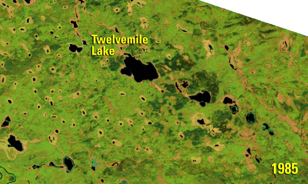
Twelvemile Lake - Change Over Time
Animation of Twelvemile Lake in the Yukon Flats ecoregion in Alaska, created using USGS Landsat data.
Animation of Twelvemile Lake in the Yukon Flats ecoregion in Alaska, created using USGS Landsat data.
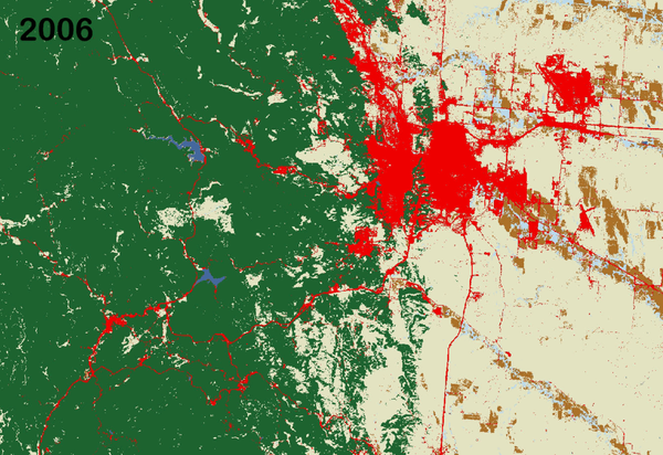
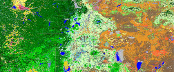
Land Change in the Black Hills - LCMAP
Animation of land cover change in the Black Hills, created using Land Change Monitoring, Assessment, and Projection data from the USGS Earth Resources Observation and Science (EROS) Center.
Animation of land cover change in the Black Hills, created using Land Change Monitoring, Assessment, and Projection data from the USGS Earth Resources Observation and Science (EROS) Center.

Landsat image of center pivot irrigation fields in the Arabian Desert
Landsat image of center pivot irrigation fields in the Arabian DesertCenter pivot irrigation fields in the Arabian Desert are visible in this Landsat 8 image near Meegowa, Saudi Arabia. The image was acquired on Oct 10, 2018 and is shown in a color infrared band combination (Bands 5,4,3).
LANDFIRE- Landscape Fire and Resource Management Planning Tools
LANDFIRE- Landscape Fire and Resource Management Planning ToolsLANDFIRE Existing Vegetation Type imagery.
LANDFIRE- Landscape Fire and Resource Management Planning Tools
LANDFIRE- Landscape Fire and Resource Management Planning ToolsLANDFIRE Existing Vegetation Type imagery.

Fire Potential Index (FPI) forecast
The FPI is most similar to the Energy Release Component of the National Fire Danger Rating System in that both are moisture related indexes and neither indicates the effect of wind on fire potential.
The FPI is most similar to the Energy Release Component of the National Fire Danger Rating System in that both are moisture related indexes and neither indicates the effect of wind on fire potential.

Africa
Africa, the second largest continent, is a mix of steamy rainforests, vast grasslands, and arid deserts. It has no long mountain ranges, but is home to the world's largest hot desert, the Sahara, and its longest river, the Nile. The featured area is the central South Atlantic coastal region of Namibia, including the cities of Walvis Bay and Windhoek.
Africa, the second largest continent, is a mix of steamy rainforests, vast grasslands, and arid deserts. It has no long mountain ranges, but is home to the world's largest hot desert, the Sahara, and its longest river, the Nile. The featured area is the central South Atlantic coastal region of Namibia, including the cities of Walvis Bay and Windhoek.

Colima Volcano
Snow-capped Colima Volcano, the most active volcano in Mexico, rises abruptly from the surrounding landscape in the state of Jalisco. Colima is actually a melding of two volcanoes, the older Nevado de Colima to the north and the younger, historically active Volcan de Colima to the south. Legend has it that gods sit atop the volcano on thrones of fire and ice.
Snow-capped Colima Volcano, the most active volcano in Mexico, rises abruptly from the surrounding landscape in the state of Jalisco. Colima is actually a melding of two volcanoes, the older Nevado de Colima to the north and the younger, historically active Volcan de Colima to the south. Legend has it that gods sit atop the volcano on thrones of fire and ice.

Australia
Australia is the smallest, and flattest, of all the continents. Its surface details are largely the result of erosion. Many rivers drain into the continent's harsh, arid interior, where they terminate in salt lakes that are dry for most of the year.
Australia is the smallest, and flattest, of all the continents. Its surface details are largely the result of erosion. Many rivers drain into the continent's harsh, arid interior, where they terminate in salt lakes that are dry for most of the year.

MacDonnell Ranges
The MacDonnell Ranges are a band of mountains spanning Australia's arid interior. Only a portion of the Ranges can be seen in this image.
The MacDonnell Ranges are a band of mountains spanning Australia's arid interior. Only a portion of the Ranges can be seen in this image.

Lake Disappointment
Surrounded by sand dunes, Lake Disappointment is an ephemeral salt lake in one of the most remote areas of Western Australia. An early explorer supposedly named the lake in 1897 after following a number of creeks that he thought would lead to a large lake; they did, but the lake's extremely salty water was not drinkable.
Surrounded by sand dunes, Lake Disappointment is an ephemeral salt lake in one of the most remote areas of Western Australia. An early explorer supposedly named the lake in 1897 after following a number of creeks that he thought would lead to a large lake; they did, but the lake's extremely salty water was not drinkable.

Operations at the Donnell Fire in Stanislaus National Forest, California
Operations at the Donnell Fire in Stanislaus National Forest, CaliforniaUSDA Forest Service and California state firefighters work together in a night operation to push back a fire line at the Donnell Fire in Stanislaus National Forest, California. Forest Service photo by Cecilio Ricardo

Landsat 5 image of Tampa Bay Florida 1991
Landsat 5 captured this image of the Tampa Bay, Florida area on March 22, 1991.
Bands 7,2,1
Image processed at Center for Coastal Geology, St. Petersburg, Florida.
Landsat 5 captured this image of the Tampa Bay, Florida area on March 22, 1991.
Bands 7,2,1
Image processed at Center for Coastal Geology, St. Petersburg, Florida.

8 Million Landsat Scenes
The Landsat archive has added its 8 millionth scene. This stunning image was captured by Landsat 8 on July 28, 2018. It shows the coastline of Nordaustlandet, the second-largest island in Norway’s Svalbard archipelago.
The Landsat archive has added its 8 millionth scene. This stunning image was captured by Landsat 8 on July 28, 2018. It shows the coastline of Nordaustlandet, the second-largest island in Norway’s Svalbard archipelago.

Icy Vortex
Appearing as if an artist imitating Jackson Pollock had randomly spurted ink onto the canvas, this image shows swirling ice in the Foxe Basin of northern Canada. Even though the image is from late July, there was still ice floating in the water this far north.
Appearing as if an artist imitating Jackson Pollock had randomly spurted ink onto the canvas, this image shows swirling ice in the Foxe Basin of northern Canada. Even though the image is from late July, there was still ice floating in the water this far north.

Sand Waves
Resembling choppy waters in a rough sea, this image is an infrared exposition of a sand sea in Namibia. Sand dunes surround a crescent-shaped rocky hill. This inselberg is hard rock that resisted the erosion that took place over time around it. The inselberg disrupts the deposition of sand, changing the dune pattern.
Resembling choppy waters in a rough sea, this image is an infrared exposition of a sand sea in Namibia. Sand dunes surround a crescent-shaped rocky hill. This inselberg is hard rock that resisted the erosion that took place over time around it. The inselberg disrupts the deposition of sand, changing the dune pattern.

Rapid Ice Movement
One glacier on Russian islands in the Arctic Ocean surprised scientists with its rapid change. After decades of normal, slow movement, a glacier draining Vavilov Ice Cap sprang forward, accelerating rapidly after 2013. This fast movement is extremely rare for cold-based glaciers. In 5 years, the ice tongue doubled in size.
One glacier on Russian islands in the Arctic Ocean surprised scientists with its rapid change. After decades of normal, slow movement, a glacier draining Vavilov Ice Cap sprang forward, accelerating rapidly after 2013. This fast movement is extremely rare for cold-based glaciers. In 5 years, the ice tongue doubled in size.
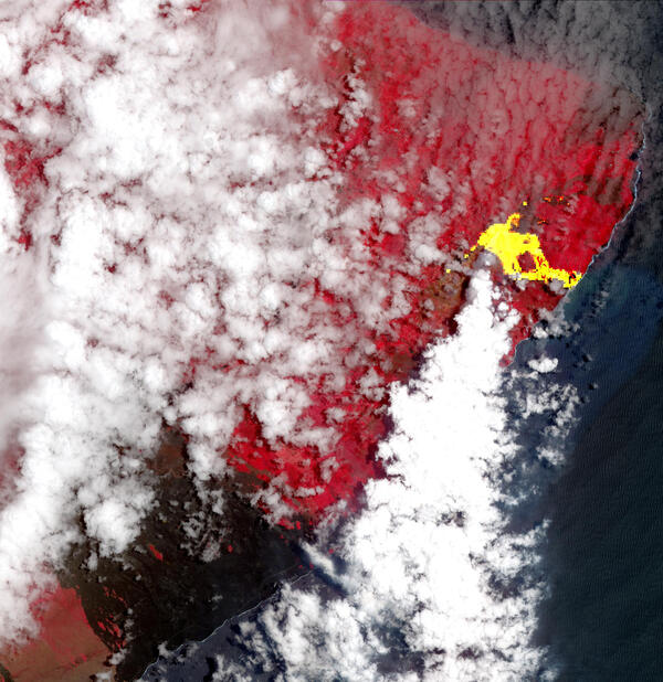
ASTER image of an eruption at Kilauea
This ASTER image from May 22, 2018, of an eruption at Kilauea in Hawaii displays vegetation in red, clouds in white and the hot lava flows, detected by ASTER's thermal infrared channels, overlaid in yellow. Lava flows from the eruption had reached the ocean, and the combination of molten lava and seawater produced clouds of noxious gases, such as hydrogen sulfide.
This ASTER image from May 22, 2018, of an eruption at Kilauea in Hawaii displays vegetation in red, clouds in white and the hot lava flows, detected by ASTER's thermal infrared channels, overlaid in yellow. Lava flows from the eruption had reached the ocean, and the combination of molten lava and seawater produced clouds of noxious gases, such as hydrogen sulfide.

Solai Dam Tragedy in Kenya
Heavy spring rains and widespread flooding has killed more than 150 people and displaced thousands in Kenya this year.
Heavy spring rains and widespread flooding has killed more than 150 people and displaced thousands in Kenya this year.