
When landmasses collide, rock layers can break. Geologists call these breaks "faults." Rock layers are offset in this image in western China, making the faults remarkably clear. The different colors indicate rocks that formed at different times and in different environments.
Images
Peruse our selection of remote sensing and Earth science imagery below.
Filter Total Items: 869

Faults
When landmasses collide, rock layers can break. Geologists call these breaks "faults." Rock layers are offset in this image in western China, making the faults remarkably clear. The different colors indicate rocks that formed at different times and in different environments.

Geometric Desert
Geometric shapes lie across the emptiness of the Sahara Desert in southern Egypt. Each point is a center pivot irrigation field a little less than 1 kilometer (0.6 mile) across. With no surface water in this region, wells pump underground water to rotating sprinklers from the huge Nubian Sandstone aquifer, which lies underneath the desert.
Geometric shapes lie across the emptiness of the Sahara Desert in southern Egypt. Each point is a center pivot irrigation field a little less than 1 kilometer (0.6 mile) across. With no surface water in this region, wells pump underground water to rotating sprinklers from the huge Nubian Sandstone aquifer, which lies underneath the desert.

Earth as Art 4 - Ord River
This image, which shows the tropical estuary of the Ord River in Australia, is part of the Earth as Art 4 series.
This image, which shows the tropical estuary of the Ord River in Australia, is part of the Earth as Art 4 series.

Example of Landsat 8 OLI/TIRS Collection 2 level-2 science products
Example of Landsat 8 OLI/TIRS Collection 2 level-2 science productsExample of the Landsat 8 OLI/TIRS Collection 2 level-2 science products. Left: Landsat 8 level-2 surface reflectance image. Right: Landsat 8 level-2 surface temperature image. The data was acquired on May 3, 2013 (path 140 row 41).

Senegal biodiversity - 1984
A scene along a road in east central Senegal, photographed in 1984 by U.S. Geological Survey Scientist G. Gray Tappan as part of his work on West African land cover. Tappan photographed the scene again in 2013.
A scene along a road in east central Senegal, photographed in 1984 by U.S. Geological Survey Scientist G. Gray Tappan as part of his work on West African land cover. Tappan photographed the scene again in 2013.

Senegal biodiversity - 2013
A scene along a road in east-central Senegal, photographed in 2013 by U.S. Geological Survey Scientist G. Gray Tappan as part of his work on West African land cover. Tappan photographed the scene again in 2013.
A scene along a road in east-central Senegal, photographed in 2013 by U.S. Geological Survey Scientist G. Gray Tappan as part of his work on West African land cover. Tappan photographed the scene again in 2013.

Boulder, Colorado - Landsat 8
Landsat 8’s first image captured the area where the Great Plains and Rocky Mountains meet in Colorado in March 2013. The natural-color image shows the coniferous forest of the mountains coming down to the dormant plains. Boulder, Colorado, sits in the middle of the image.
Landsat 8’s first image captured the area where the Great Plains and Rocky Mountains meet in Colorado in March 2013. The natural-color image shows the coniferous forest of the mountains coming down to the dormant plains. Boulder, Colorado, sits in the middle of the image.

Mexico’s Biosphere
Much of this image consists of the Reserva de la Biosfera Pantanos de Centla, a biosphere reserve in southern Mexico that protects wetlands in the area. The water bodies, mangroves, and forests are a sanctuary for a great variety of wildlife.
Much of this image consists of the Reserva de la Biosfera Pantanos de Centla, a biosphere reserve in southern Mexico that protects wetlands in the area. The water bodies, mangroves, and forests are a sanctuary for a great variety of wildlife.

Landsat 5 MSS Image of Michigan’s Upper Peninsula
This image of Michigan’s Upper Peninsula was captured by the Multispectral Scanner (MSS) instrument onboard the Landsat 5 satellite on January 7, 2013.
This image of Michigan’s Upper Peninsula was captured by the Multispectral Scanner (MSS) instrument onboard the Landsat 5 satellite on January 7, 2013.

Rural village beneath escarpment near Dapaong, western Togo, 2012
Rural village beneath escarpment near Dapaong, western Togo, 2012Photograph of a village near Padaong, Togo, from West Africa: Land Use and Land Cover Dynamics, 2016
Rural village beneath escarpment near Dapaong, western Togo, 2012
Rural village beneath escarpment near Dapaong, western Togo, 2012Photograph of a village near Padaong, Togo, from West Africa: Land Use and Land Cover Dynamics, 2016

Dapaong, Togo
photograph of landscape and dwellings near Dapaong, northern Togolese Republic
photograph of landscape and dwellings near Dapaong, northern Togolese Republic

Niger River - 2004
The Niger River, as seen from Niamby, Niger, photographed in 2004 by U.S. Geological Survey Scientist G. Gray Tappan as part of his work on West African land cover. Tappan photographed the scene again after a flood in 2012.
The Niger River, as seen from Niamby, Niger, photographed in 2004 by U.S. Geological Survey Scientist G. Gray Tappan as part of his work on West African land cover. Tappan photographed the scene again after a flood in 2012.

Niger River - 2012
The Niger River, as seen from Niamby, Niger, photographed after flooding in 2012 by U.S. Geological Survey Scientist G. Gray Tappan as part of his work on West African land cover. Tappan previously photographed the scene in 2004.
The Niger River, as seen from Niamby, Niger, photographed after flooding in 2012 by U.S. Geological Survey Scientist G. Gray Tappan as part of his work on West African land cover. Tappan previously photographed the scene in 2004.

Tuscaloosa-Birmingham Tornado Scar, April 2011
The roughly west-east trail of destruction from the April 27, 2011, Tuscaloosa-Birmingham tornado is clearly visible in these Landsat images. This was one of 358 recorded tornadoes during the April 25-28, 2011, tornado outbreak, the most severe in U.S. history.
The roughly west-east trail of destruction from the April 27, 2011, Tuscaloosa-Birmingham tornado is clearly visible in these Landsat images. This was one of 358 recorded tornadoes during the April 25-28, 2011, tornado outbreak, the most severe in U.S. history.

McKinley Super Computer
McKinley is the USGS's flagship supercomputer installed and housed at the EROS Data Center in Sioux Falls, SD. Estimated peak computational performance is expected to be ~660 Tflop/s.
Learn more here: USGS McKinley Supercomputer
McKinley is the USGS's flagship supercomputer installed and housed at the EROS Data Center in Sioux Falls, SD. Estimated peak computational performance is expected to be ~660 Tflop/s.
Learn more here: USGS McKinley Supercomputer

Landsat 5 image of Gascoyne, Australia
Landsat 5 image of Gascoyne, West Australia. The image was acquired on December 12, 2010.
Learn more about Landsat at www.usgs.gov/landsat
Landsat 5 image of Gascoyne, West Australia. The image was acquired on December 12, 2010.
Learn more about Landsat at www.usgs.gov/landsat

Landsat 5 image showing the Seattle, Washington area
Landsat 5 image showing the Seattle, Washington areaExample of the Landsat 4-5 TM Collection 2 level-1 product. This Landsat 5 image was acquired on October 6, 2010 near Seattle, Washington and is shown as a natural color composite using the red, green, and blue bands (bands 3,2,1).

Example of the Landsat 4-5 TM Collection 2 level-2 science products
Example of the Landsat 4-5 TM Collection 2 level-2 science productsExample of the Landsat 4-5 TM Collection 2 level-2 science products. Left: Landsat 5 level-2 surface reflectance image. Right: Landsat 5 level-2 surface temperature image. The data was acquired on October 6, 2010 (path 47 row 27).

Expanding Suburbs
A scene at the edge of a suburban housing development and farmland in Frederick County, Maryland.
A scene at the edge of a suburban housing development and farmland in Frederick County, Maryland.
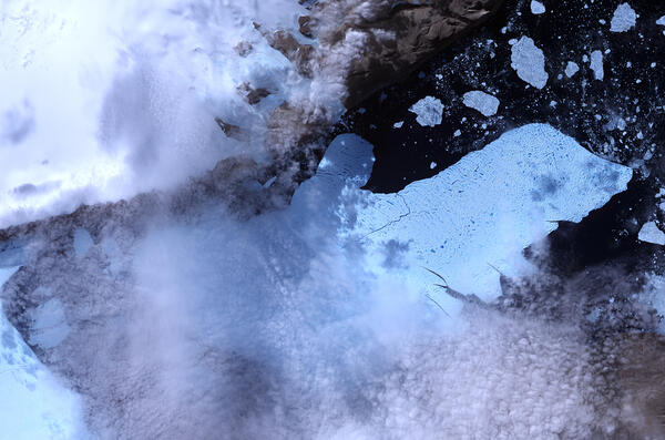
ASTER image of Petermann Glacier and an ice island
ASTER image of Petermann Glacier and an ice islandThis ASTER image acquired August 11, 2010, shows a massive ice island dominating the center of the image that had broken off of the Petermann Glacier in northwestern Greenland on August 5, 2010. This false-color image of the ice island displays ice in light blue, water as nearly black, and clouds as nearly white.
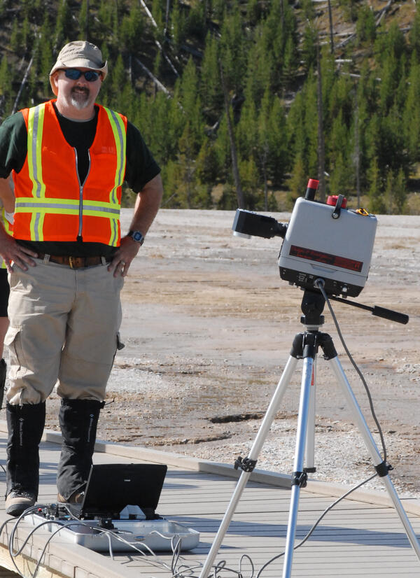
R. Greg Vaughan at Yellowstone National Park
R. Greg Vaughan of the USGS Astrogeology Science Center does field work at Yellowstone National Park. Vaughan monitors thermal features in his role as the remote sensing lead for the Yellowstone Volcano Observatory. USGS photo
R. Greg Vaughan of the USGS Astrogeology Science Center does field work at Yellowstone National Park. Vaughan monitors thermal features in his role as the remote sensing lead for the Yellowstone Volcano Observatory. USGS photo