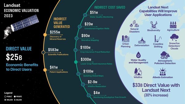
A map generated by 2023 Annual National Land Cover Database (Annual NLCD) depicting the different land cover classes.
Images
Peruse our selection of remote sensing and Earth science imagery below.
A map generated by 2023 Annual National Land Cover Database (Annual NLCD) depicting the different land cover classes.
The Park Fire north of Sacramento in California forced thousands of residents to evacuate in late July as it spread to over 370,000 acres. The fire started on July 24th. Landsat 8 captured an image of the fire two days later.
Infographic for Report "Economic Valuation of Landsat and Landsat Next 2023"
Infographic for Report "Economic Valuation of Landsat and Landsat Next 2023"This infographic is from the report "Economic Valuation of Landsat and Landsat Next 2023," which shows that Landsat's direct value in 2023 was \$25.6 billion. The report and infographic also show well over \$1 billion in estimated indirect economic value.
JACIE 2025 will be held April 7 - 11, 2025 at USGS Headquarters in Reston, Virginia.
Annual JACIE Workshops are sponsored by government agencies and allow remote sensing experts to discuss system capabilities, calibration, and the impacts of data quality on various applications.
Highlights of JACIE Workshops include:
The Phoenix, Arizona metropolitan area, also known as the Valley of the Sun, is comprised of more than 14,600 square miles and is considered the largest metropolitan area in the southwestern United States. The desert climate and abundant sunshine of the area are main factors in population growth and urban sprawl.
The Railroad Valley Playa, located in east central Nevada, measures about 80 miles long and nearly 20 miles wide, and is a vast and wide-open landscape.
Landsat 8 image of central California cropland and dairies
Landsat 8 image of central California cropland and dairiesLandsat 8 image of central California cropland and dairies, southeast of Fresno, on July 5, 2024.
Landsat 8 image of central California cropland and dairies
Landsat 8 image of central California cropland and dairiesLandsat 8 image of central California cropland and dairies, southeast of Fresno, on July 5, 2024.
Each year, June is National Ocean Month!
South Dakota is home to the fabled “Black Hills.” Seen from a distance, these pine-covered hills, rising several thousand feet above the surrounding prairie, appear black.
A map of crop types found in a small area of central California
A map of crop types found in a small area of central CaliforniaA Land IQ map of crop types found in a small area of central California, southeast of Fresno, in July 2024. The classifications are based on remote sensing and ground data. Used with permission from Land IQ.
A false color Landsat 8 image from July 24, 2024, of Waubay Lake and Bitter Lake in Day County, South Dakota.
Landsat 8 image acquired on June 24, 2024, showing the floods that affected South Dakota and Iowa. A multi-day heavy rainfall event in South Dakota, Iowa, and Minnesota led to widespread flooding across the region.
South Dakota Floods, June 24, 2024 - Union County, South Dakota, and Plymouth County, Iowa
South Dakota Floods, June 24, 2024 - Union County, South Dakota, and Plymouth County, IowaLandsat 8 image acquired on June 24, 2024, showing the floods that affected Union County, South Dakota, and Plymouth County, Iowa. A multi-day heavy rainfall event in South Dakota, Iowa, and Minnesota led to widespread flooding across the region.
Landsat 8's Operational Land Imager (OLI) captured this icy view of Ayon Island on June 17, 2024. The island's low-lying tundra and the shorelines create a picturesque view from its high latitude location in the East Siberian Sea. This unique polar landmass is separated from the mainland by the Malyy Chaunskiy Strait.
The Legacy of Landsat 7 — Citations in Policy & Publications
The Legacy of Landsat 7 — Citations in Policy & PublicationsFor 25 years, the Landsat 7 satellite acquired millions of images of Earth that supported studies of how land is used and how it has changed across urban, agriculture, forest, snow and ice-covered areas around the globe, as well as natural and manmade disasters.
Norwegian Ambassador overlooking the Landsat Satellite Receiving Antenna
Norwegian Ambassador overlooking the Landsat Satellite Receiving AntennaNorwegian Ambassador, Anniken Krutnes, overlooks the radome that houses the Landsat receiving antenna during her visit to EROS.
Norwegian Ambassador overlooking the Landsat Satellite Receiving Antenna
Norwegian Ambassador overlooking the Landsat Satellite Receiving AntennaNorwegian Ambassador, Anniken Krutnes, overlooks the radome that houses the Landsat receiving antenna during her visit to EROS.
Group photo during the Norwegian Ambassador's visit to EROS.
Norwegian Ambassador, Anniken Krutnes, learns about the Landsat Satellite Program history on a tour of USGS EROS.
USGS and German Aerospace Center sign statement of intent for upcoming Landsat Next mission.
USGS and German Aerospace Center sign statement of intent for upcoming Landsat Next mission.The U.S. Geological Survey and German Aerospace Center (Deutsches Zentrum für Luft-und Raumfahrt or DLR sign statement for plans to continue partnership with the upcoming Landsat Next satellite mission.
Inaugural U.S.-Germany Space Dialogue Space Dialogue
Inaugural U.S.-Germany Space Dialogue Space DialogueImage from the inaugural U.S.-Germany Space Dialogue Space Dialogue in Berlin on June 4, 2024.
Inaugural U.S.-Germany Space Dialogue Space Dialogue
Inaugural U.S.-Germany Space Dialogue Space DialogueImage from the inaugural U.S.-Germany Space Dialogue Space Dialogue in Berlin on June 4, 2024.
USGS and German Aerospace Center sign statement of intent for Landsat Next mission.
USGS and German Aerospace Center sign statement of intent for Landsat Next mission.USGS and German Aerospace Center sign statement of intent for upcoming Landsat Next mission.
(Left to Right): Head of the DLR Space Division Dr. Anke Pagels-Kerp and USGS Deputy Director-Operations Cindy Lodge.