An Annual NLCD Land Cover map centered are around Lake Stevens, WA
An Annual NLCD Land Cover map centered are around Lake Stevens, WAAn Annual NLCD Land Cover map of centered around Lake Stevens, WA depicting 16 land cover classes.

Official websites use .gov
A .gov website belongs to an official government organization in the United States.
Secure .gov websites use HTTPS
A lock () or https:// means you’ve safely connected to the .gov website. Share sensitive information only on official, secure websites.
Land cover is foundational information for land managers, scientists, and the general public. Many types of scientific studies have applied annual land cover information including projecting future land use, documenting forest fragmentation or conservation practices, modeling wildfire hazards, tracking water quality and quantity, and understanding change in wildlife habitat and ecosystem disturbance/disease.
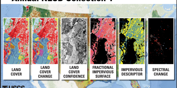
Annual NLCD offers a suite of six annual land use and land cover change in the conterminous United States. Annual NLCD Collection 1.2 is available now.

Annual NLCD Science Products are available for download from a variety of data download portals.

Science Product User Guide provides in-depth information on Annual NLCD products and methods and is available for download.
The Annual National Land Cover Database (NLCD) has harnessed the full Landsat data record to provide timely, long-term, and detailed land surface change information. Annual NLCD uses an ensemble of classification and change algorithms to map, monitor, and synthesize the complexities of land use, cover, and condition change through time. The Annual NLCD product suite offers data that describe nationwide land cover and land change over nearly four decades. A new generation of USGS Land Cover mapping, introduced in the Annual NLCD Collection 1 release, leverages advancements in artificial intelligence and machine learning techniques and runs within high-performance computing and cloud processing environments.
Citation
U.S. Geological Survey (USGS), 2024, Annual NLCD Collection 1 Science Products: U.S. Geological Survey data release, https://doi.org/10.5066/P94UXNTS
Annual NLCD is a new generation of land cover mapping that offers annual land cover and land change science products nationwide with more than four decades of data. Click on the link below to learn more about Annual NLCD.
The Annual NLCD project has generated a product suite of six geospatial raster land use and land cover science products for the conterminous United States, available annually back to 1985. Annual NLCD products will be updated annually. Check out the Science Product User Guide for in-depth information about Annual NLCD.
A suite of six annual integrated land cover and land surface change products are available for the conterminous United States. Products for Alaska and Hawaii are planned. The product suite provides powerful time-series information at a 30-m spatial resolution about annual land cover and its change across time. Products can be accessed via the data access page.
Validation of land cover and land cover change information is essential for providing authoritative products to our user community. Validation reports provide estimates of the accuracies and uncertainties of the NLCD land cover products and are derived from well-documented independent reference data. Processing flows, product specifications, uncertainties and known issues are published in validation reports to ensure consistency. See the Reference and Validation products page for more information.
Additional information on Annual NLCD and Annual NLCD science products can be found in the Science User Product Guide. The Science User Product Guide contains in-depth information about Annual NLCD including characteristics of the science products, algorithm description, and accuracy assessment.
These are related science efforts related to Annual NLCD.

View or listen to additional Annual NLCD resources.
 National Land Cover Database: Improving on a 30-Year Legacy")
This video is a recording of a previous webinar entitled: “The New Annual (1985-2023) National Land Cover Database: Improving on a 30-year Legacy.” This webinar was recorded on October 24, 2024 at the USGS EROS. The United States Geological Survey (USGS) Earth Resources Observation and Science (EROS) Center maintains one of the largest civilian collection of images of the Earth’s land surface. At...

An Annual NLCD Land Cover map of centered around Lake Stevens, WA depicting 16 land cover classes.
An Annual NLCD Land Cover map of centered around Lake Stevens, WA depicting 16 land cover classes.

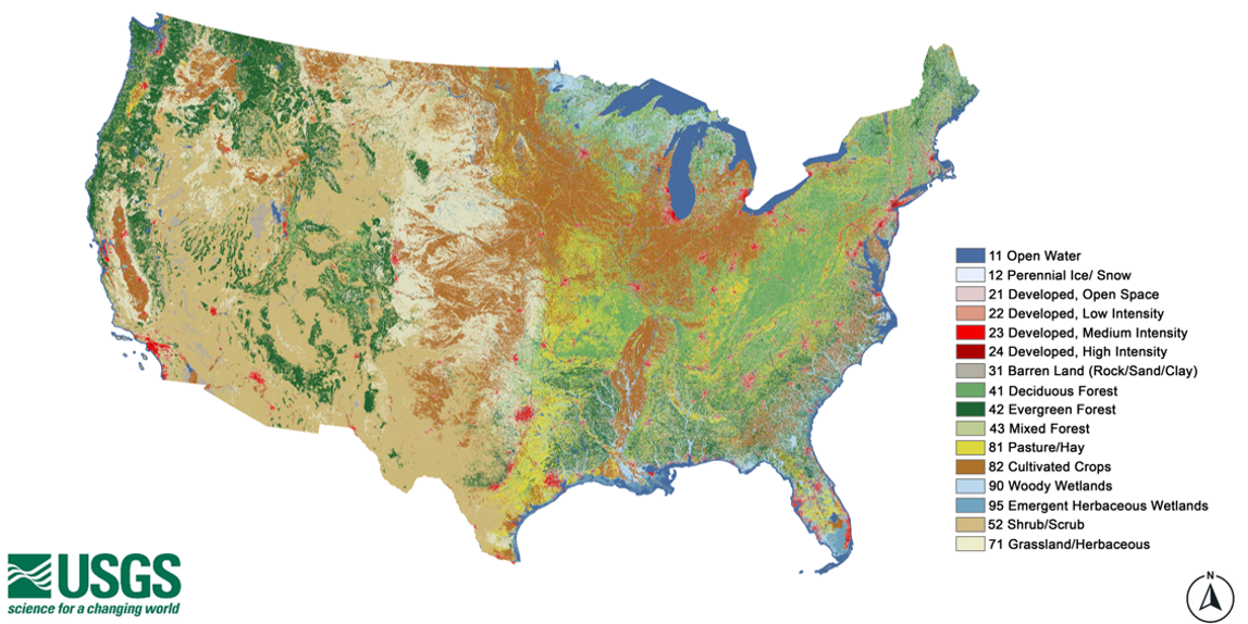
The Annual NLCD product suite offers six different land use and land cover products. The Annual NLCD Land Cover product depicts the predominant thematic land cover of 16 Anderson Level II classes within the current mapping year. The Annual NLCD Land Cover of the conterminous United States shows all Anderson Level II classes.
The Annual NLCD product suite offers six different land use and land cover products. The Annual NLCD Land Cover product depicts the predominant thematic land cover of 16 Anderson Level II classes within the current mapping year. The Annual NLCD Land Cover of the conterminous United States shows all Anderson Level II classes.
Terry Sohl helped develop the National Land Cover Database, NLCD, when he first arrived, and now he’s overseeing significant improvements to the widely used product. But that’s just one part of his new role.
Terry Sohl helped develop the National Land Cover Database, NLCD, when he first arrived, and now he’s overseeing significant improvements to the widely used product. But that’s just one part of his new role.

Based on Landsat Collection 2, NLCD 2023 will offer annual products from 1985 – 2023. Depicting urban growth for the Atlanta area, this animation shows a single Landsat U.S. ARD tile of Anderson Level II land cover classification generated from the latest prototypes.
Based on Landsat Collection 2, NLCD 2023 will offer annual products from 1985 – 2023. Depicting urban growth for the Atlanta area, this animation shows a single Landsat U.S. ARD tile of Anderson Level II land cover classification generated from the latest prototypes.
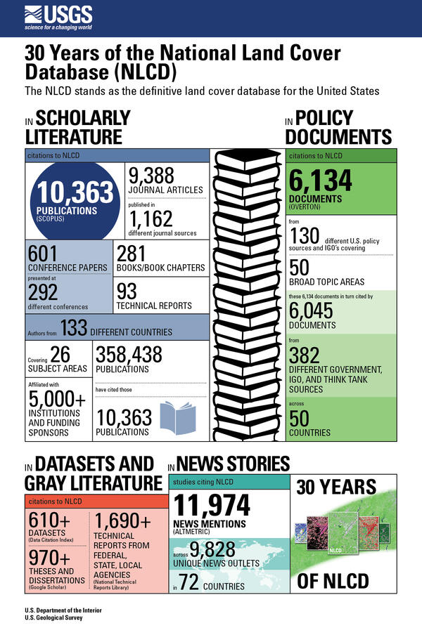
30 Years of the National Land Cover Database (NLCD)
The NLCD stands as the definitive land cover database for the United States
30 Years of the National Land Cover Database (NLCD)
The NLCD stands as the definitive land cover database for the United States
The National Land Cover Database (NLCD) has a long history as the definitive U.S. land cover product. But the newer Land Change Monitoring, Assessment and Projection (LCMAP) effort takes a longer look back in time.
The National Land Cover Database (NLCD) has a long history as the definitive U.S. land cover product. But the newer Land Change Monitoring, Assessment and Projection (LCMAP) effort takes a longer look back in time.
Several decades ago, USGS EROS employees were pioneers in land cover mapping—turning satellite imagery into a record of what covers the land, from farmland to forest to urban areas. National and global datasets with a variety of uses resulted from these efforts.
Several decades ago, USGS EROS employees were pioneers in land cover mapping—turning satellite imagery into a record of what covers the land, from farmland to forest to urban areas. National and global datasets with a variety of uses resulted from these efforts.
News items related to Annual NLCD.

Land cover is foundational information for land managers, scientists, and the general public. Many types of scientific studies have applied annual land cover information including projecting future land use, documenting forest fragmentation or conservation practices, modeling wildfire hazards, tracking water quality and quantity, and understanding change in wildlife habitat and ecosystem disturbance/disease.
Annual NLCD offers a suite of six annual land use and land cover change in the conterminous United States. Annual NLCD Collection 1.2 is available now.
Annual NLCD Science Products are available for download from a variety of data download portals.
Science Product User Guide provides in-depth information on Annual NLCD products and methods and is available for download.
The Annual National Land Cover Database (NLCD) has harnessed the full Landsat data record to provide timely, long-term, and detailed land surface change information. Annual NLCD uses an ensemble of classification and change algorithms to map, monitor, and synthesize the complexities of land use, cover, and condition change through time. The Annual NLCD product suite offers data that describe nationwide land cover and land change over nearly four decades. A new generation of USGS Land Cover mapping, introduced in the Annual NLCD Collection 1 release, leverages advancements in artificial intelligence and machine learning techniques and runs within high-performance computing and cloud processing environments.
Citation
U.S. Geological Survey (USGS), 2024, Annual NLCD Collection 1 Science Products: U.S. Geological Survey data release, https://doi.org/10.5066/P94UXNTS
Annual NLCD is a new generation of land cover mapping that offers annual land cover and land change science products nationwide with more than four decades of data. Click on the link below to learn more about Annual NLCD.
The Annual NLCD project has generated a product suite of six geospatial raster land use and land cover science products for the conterminous United States, available annually back to 1985. Annual NLCD products will be updated annually. Check out the Science Product User Guide for in-depth information about Annual NLCD.
A suite of six annual integrated land cover and land surface change products are available for the conterminous United States. Products for Alaska and Hawaii are planned. The product suite provides powerful time-series information at a 30-m spatial resolution about annual land cover and its change across time. Products can be accessed via the data access page.
Validation of land cover and land cover change information is essential for providing authoritative products to our user community. Validation reports provide estimates of the accuracies and uncertainties of the NLCD land cover products and are derived from well-documented independent reference data. Processing flows, product specifications, uncertainties and known issues are published in validation reports to ensure consistency. See the Reference and Validation products page for more information.
Additional information on Annual NLCD and Annual NLCD science products can be found in the Science User Product Guide. The Science User Product Guide contains in-depth information about Annual NLCD including characteristics of the science products, algorithm description, and accuracy assessment.
These are related science efforts related to Annual NLCD.
View or listen to additional Annual NLCD resources.
This video is a recording of a previous webinar entitled: “The New Annual (1985-2023) National Land Cover Database: Improving on a 30-year Legacy.” This webinar was recorded on October 24, 2024 at the USGS EROS. The United States Geological Survey (USGS) Earth Resources Observation and Science (EROS) Center maintains one of the largest civilian collection of images of the Earth’s land surface. At...
An Annual NLCD Land Cover map of centered around Lake Stevens, WA depicting 16 land cover classes.
An Annual NLCD Land Cover map of centered around Lake Stevens, WA depicting 16 land cover classes.
The Annual NLCD product suite offers six different land use and land cover products. The Annual NLCD Land Cover product depicts the predominant thematic land cover of 16 Anderson Level II classes within the current mapping year. The Annual NLCD Land Cover of the conterminous United States shows all Anderson Level II classes.
The Annual NLCD product suite offers six different land use and land cover products. The Annual NLCD Land Cover product depicts the predominant thematic land cover of 16 Anderson Level II classes within the current mapping year. The Annual NLCD Land Cover of the conterminous United States shows all Anderson Level II classes.
Terry Sohl helped develop the National Land Cover Database, NLCD, when he first arrived, and now he’s overseeing significant improvements to the widely used product. But that’s just one part of his new role.
Terry Sohl helped develop the National Land Cover Database, NLCD, when he first arrived, and now he’s overseeing significant improvements to the widely used product. But that’s just one part of his new role.
Based on Landsat Collection 2, NLCD 2023 will offer annual products from 1985 – 2023. Depicting urban growth for the Atlanta area, this animation shows a single Landsat U.S. ARD tile of Anderson Level II land cover classification generated from the latest prototypes.
Based on Landsat Collection 2, NLCD 2023 will offer annual products from 1985 – 2023. Depicting urban growth for the Atlanta area, this animation shows a single Landsat U.S. ARD tile of Anderson Level II land cover classification generated from the latest prototypes.
30 Years of the National Land Cover Database (NLCD)
The NLCD stands as the definitive land cover database for the United States
30 Years of the National Land Cover Database (NLCD)
The NLCD stands as the definitive land cover database for the United States
The National Land Cover Database (NLCD) has a long history as the definitive U.S. land cover product. But the newer Land Change Monitoring, Assessment and Projection (LCMAP) effort takes a longer look back in time.
The National Land Cover Database (NLCD) has a long history as the definitive U.S. land cover product. But the newer Land Change Monitoring, Assessment and Projection (LCMAP) effort takes a longer look back in time.
Several decades ago, USGS EROS employees were pioneers in land cover mapping—turning satellite imagery into a record of what covers the land, from farmland to forest to urban areas. National and global datasets with a variety of uses resulted from these efforts.
Several decades ago, USGS EROS employees were pioneers in land cover mapping—turning satellite imagery into a record of what covers the land, from farmland to forest to urban areas. National and global datasets with a variety of uses resulted from these efforts.
News items related to Annual NLCD.


