
This graphic displays a few of the common band Red-Green-Blue (RGB) combinations of Landsat data. For more information about using Landsat bands in your research, visit the following pages:
USGS EROS Archive - Landsat Archives - Landsat 8-9 Operational Land Imager and Thermal Infrared Sensor Collection 2 Level-1 Data
Active
By Earth Resources Observation and Science (EROS) Center
March 4, 2020
Landsat 8-9 Operational Land Imager (OLI) and Thermal Infrared Sensor (TIRS) Collection 2 Level-1 15- to 30-meter multispectral data.
Dataset Citation
Please cite this dataset in the following manner:
Earth Resources Observation and Science (EROS) Center. (2020). Landsat 8-9 Operational Land Imager / Thermal Infrared Sensor Level-1, Collection 2 [dataset]. U.S. Geological Survey. https://doi.org/10.5066/P975CC9B
Media

Sources/Usage: Public Domain. View Media Details
The Operational Land Imager (OLI) and Thermal Infrared Sensor (TIRS) are onboard the Landsat 8 satellite and have acquired images of the Earth since February 2013. Copies of the same instruments are onboard the Landsat 9 satellite, which was launched September 27, 2021. The OLI and TIRS on each satellite collect images of the Earth with a 16-day repeat cycle, referenced to the Worldwide Reference System-2. Together, the satellites have an 8-day acquisition offset. The approximate scene size is 170 km north-south by 183 km east-west (106 mi by 114 mi).
Delivered Landsat 8-9 Level-1 products consist of 11 spectral bands with a spatial resolution of 30 meters for bands 1-7 and bands 9-11, and 15-meters for the panchromatic band 8. (See Landsat satellite band designations for more information.) Each Level-1 product typically include both OLI and TIRS data; however, there may be times when one of the sensors cannot acquire data; the first two values of the Landsat Product Identifier designates the data contained in each scene: (Landsat 8 used as examples)
- LC08_L1TP_003055_20170207_20170216_01_T1 = Combined (both OLI and TIRS data)
- LO08_L1TP_021047_20150304_20170227_01_T1 = OLI data only
- LT08_L1GT_137206_20170202_20170215_01_T2 = TIRS data only
A Quality Assurance (QA.tif) band is also included in the Level-1 product. This file provides bit information regarding conditions that may affect the accuracy and usability of a given pixel – clouds, water, or snow, for example.
Standard Processing Parameters
All Collection 2 Landsat 8-9 OLI/TIRS Collection 2 Level-1 data are processed using the Landsat Product Generation System (LPGS) with the following parameters applied:
| Parameter | |
|---|---|
| Pixel Size: |
|
| Data Characteristics: |
|
| Data Delivery: | HTTPS Download within 6 hours of acquisition |
Landsat 8-9 OLI/TIRS Collection 2 Level-1 Data
Landsat Tiers are the inventory structure for Landsat Collection Level-1 data products and are based on data quality and level of processing. All scenes in the Landsat archive are assigned to a Collection category. The purpose of Collection categories is to support rapid and easy identification of suitable scenes for time-series pixel level analysis. These data have well-characterized radiometric quality and are cross calibrated among the different Landsat sensors.
Collection Category (Tier)
- Tier 1 (T1) – Contains the highest quality Level-1 Terrain Precision (L1TP) data considered suitable for time-series analysis. The georegistration is consistent and within prescribed tolerances [<12m root mean square error (RMSE)].
- Tier 2 (T2) – Contains L1TP scenes not meeting Tier 1 criteria and all Systematic Terrain (L1GT) and Geometric Systematic (L1GS) scenes. Users interested in Tier 2 scenes can evaluate the RMSE and other properties to determine suitability for use in their applications and studies.
- Real-Time (RT) (Landsat 8 only) – Contains newly acquired Landsat 8 scenes, which require a period of evaluation and calibration adjustment after acquisition but are processed immediately based on preliminary calibration coefficients, assigned to the temporary RT Tier, and made available for download. When definitive calibration information becomes available (approximately 14-16 days), these scenes are reprocessed, assigned to the appropriate Tier 1 or Tier 2 category, and removed from the RT Tier.
- Visit the Landsat Levels of Processing webpage to learn more about how georegistration is applied to Landsat Level-1 products.
The Landsat Collection 2 webpage contains additional details about Landsat Collection 2 Level-1 products.
Coverage Maps
Coverage Maps indicating the availability of Landsat 8-9 Collection products are available for download.
Additional Information
- Landsat Collection 2
- Project Documentation
- Landsat FAQs
- USGS Landsat - Earth Observation Satellites Fact Sheet
- Landsat 9 Data Users Handbook
- Landsat 8 Data Users Handbook
Access Data
Click EarthExplorer Dataset Link to open EarthExplorer with this dataset selected.
Landsat 8-9 Collection 2 Level-1 scenes held in the USGS archive can be searched using EarthExplorer. On EarthExplorer, Landsat 8-9 scenes can be found under the Landsat menu in the “Landsat Collection 2 Level-1” section, in the “Landsat 8-9 OLI/TIRS C2 L1” dataset. Landsat Full Resolution Browse Images can also be downloaded from this location.
The Landsat Data Access summary table provides information about all Landsat Collection 2 data access options.
Newly acquired Landsat 8 and Landsat 9 scenes become available for search and download within 6 hours after data acquisition. To view real-time acquisitions of Landsat 8-9, visit the EarthNow! Landsat Image Viewer.
Data Citation History
The preferred citation for this dataset was revised in 2024 to improve accuracy and alignment with USGS Fundamental Science Practices. The dataset digital object identifier (DOI) and version did not change.
Please cite this dataset in the following manner:
Earth Resources Observation and Science (EROS) Center. (2020). Landsat 8-9 Operational Land Imager / Thermal Infrared Sensor Level-1, Collection 2 [dataset]. U.S. Geological Survey. https://doi.org/10.5066/P975CC9B
The previously used citation shown below is provided here for historical reference only:
Earth Resources Observation And Science (EROS) Center. (2013). Collection-2 Landsat 8-9 OLI (Operational Land Imager) and TIRS (Thermal Infrared Sensor) Level-1 Data Products [dataset]. U.S. Geological Survey. https://doi.org/10.5066/P975CC9B
Below are other science products associated with this product.

USGS EROS Archive - Landsat Archives - Landsat 8-9 OLI/TIRS Collection 2 Level-2 Science Products
Landsat 8-9 Operational Land Imager (OLI) and Thermal Infrared (TIRS) Collection 2 Level-2 Science Products 30-meter multispectral data.

USGS EROS Archive - Landsat Archives - Landsat 7 Enhanced Thematic Mapper Plus Collection 2 Level-1 Data
Landsat 7 Enhanced Thematic Mapper Plus (ETM+) Collection 2 Level-1 15- to 30-meter multispectral data. (1999 to January 2024).

USGS EROS Archive - Landsat Archives - Landsat 4-5 Thematic Mapper Collection 2 Level-1 Data
Landsat 4-5 Thematic Mapper (TM) Collection 2 Level-1 30-meter multispectral data. (1982 to 2012)

USGS EROS Archive - Landsat Archives - Landsat 1-5 Multispectral Scanner Collection 2 Level-1 Data
Landsat 1-5 Multispectral Scanner (MSS) Collection 2 Level-1 80-meter multispectral data. Delivered data processed to 60-meter pixel size. (1972-2013)
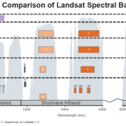
Spectral Bandpasses for all Landsat Sensors
This image shows the spectral bandpasses for the sensors on all Landsat satellites. Landsat 1-5 Multispectral Scanner System (MSS)*: the sensor onboard each satellite acquired data in four spectral bands in the visible and near infrared spectrums Landsat 4 and Landsat 5 Thematic Mapper (TM): the sensor onboard each satellite acquired data in seven spectral bands, and included shortwave infrared...

Common Landsat Band Combinations
This graphic displays a few of the common band Red-Green-Blue (RGB) combinations of Landsat data. For more information about using Landsat bands in your research, visit the following pages:
Landsat 8-9 Operational Land Imager (OLI) and Thermal Infrared Sensor (TIRS) Collection 2 Level-1 15- to 30-meter multispectral data.
Dataset Citation
Please cite this dataset in the following manner:
Earth Resources Observation and Science (EROS) Center. (2020). Landsat 8-9 Operational Land Imager / Thermal Infrared Sensor Level-1, Collection 2 [dataset]. U.S. Geological Survey. https://doi.org/10.5066/P975CC9B
Media
Sources/Usage: Public Domain. View Media Details
The Operational Land Imager (OLI) and Thermal Infrared Sensor (TIRS) are onboard the Landsat 8 satellite and have acquired images of the Earth since February 2013. Copies of the same instruments are onboard the Landsat 9 satellite, which was launched September 27, 2021. The OLI and TIRS on each satellite collect images of the Earth with a 16-day repeat cycle, referenced to the Worldwide Reference System-2. Together, the satellites have an 8-day acquisition offset. The approximate scene size is 170 km north-south by 183 km east-west (106 mi by 114 mi).
Delivered Landsat 8-9 Level-1 products consist of 11 spectral bands with a spatial resolution of 30 meters for bands 1-7 and bands 9-11, and 15-meters for the panchromatic band 8. (See Landsat satellite band designations for more information.) Each Level-1 product typically include both OLI and TIRS data; however, there may be times when one of the sensors cannot acquire data; the first two values of the Landsat Product Identifier designates the data contained in each scene: (Landsat 8 used as examples)
- LC08_L1TP_003055_20170207_20170216_01_T1 = Combined (both OLI and TIRS data)
- LO08_L1TP_021047_20150304_20170227_01_T1 = OLI data only
- LT08_L1GT_137206_20170202_20170215_01_T2 = TIRS data only
A Quality Assurance (QA.tif) band is also included in the Level-1 product. This file provides bit information regarding conditions that may affect the accuracy and usability of a given pixel – clouds, water, or snow, for example.
Standard Processing Parameters
All Collection 2 Landsat 8-9 OLI/TIRS Collection 2 Level-1 data are processed using the Landsat Product Generation System (LPGS) with the following parameters applied:
| Parameter | |
|---|---|
| Pixel Size: |
|
| Data Characteristics: |
|
| Data Delivery: | HTTPS Download within 6 hours of acquisition |
Landsat 8-9 OLI/TIRS Collection 2 Level-1 Data
Landsat Tiers are the inventory structure for Landsat Collection Level-1 data products and are based on data quality and level of processing. All scenes in the Landsat archive are assigned to a Collection category. The purpose of Collection categories is to support rapid and easy identification of suitable scenes for time-series pixel level analysis. These data have well-characterized radiometric quality and are cross calibrated among the different Landsat sensors.
Collection Category (Tier)
- Tier 1 (T1) – Contains the highest quality Level-1 Terrain Precision (L1TP) data considered suitable for time-series analysis. The georegistration is consistent and within prescribed tolerances [<12m root mean square error (RMSE)].
- Tier 2 (T2) – Contains L1TP scenes not meeting Tier 1 criteria and all Systematic Terrain (L1GT) and Geometric Systematic (L1GS) scenes. Users interested in Tier 2 scenes can evaluate the RMSE and other properties to determine suitability for use in their applications and studies.
- Real-Time (RT) (Landsat 8 only) – Contains newly acquired Landsat 8 scenes, which require a period of evaluation and calibration adjustment after acquisition but are processed immediately based on preliminary calibration coefficients, assigned to the temporary RT Tier, and made available for download. When definitive calibration information becomes available (approximately 14-16 days), these scenes are reprocessed, assigned to the appropriate Tier 1 or Tier 2 category, and removed from the RT Tier.
- Visit the Landsat Levels of Processing webpage to learn more about how georegistration is applied to Landsat Level-1 products.
The Landsat Collection 2 webpage contains additional details about Landsat Collection 2 Level-1 products.
Coverage Maps
Coverage Maps indicating the availability of Landsat 8-9 Collection products are available for download.
Additional Information
- Landsat Collection 2
- Project Documentation
- Landsat FAQs
- USGS Landsat - Earth Observation Satellites Fact Sheet
- Landsat 9 Data Users Handbook
- Landsat 8 Data Users Handbook
Access Data
Click EarthExplorer Dataset Link to open EarthExplorer with this dataset selected.
Landsat 8-9 Collection 2 Level-1 scenes held in the USGS archive can be searched using EarthExplorer. On EarthExplorer, Landsat 8-9 scenes can be found under the Landsat menu in the “Landsat Collection 2 Level-1” section, in the “Landsat 8-9 OLI/TIRS C2 L1” dataset. Landsat Full Resolution Browse Images can also be downloaded from this location.
The Landsat Data Access summary table provides information about all Landsat Collection 2 data access options.
Newly acquired Landsat 8 and Landsat 9 scenes become available for search and download within 6 hours after data acquisition. To view real-time acquisitions of Landsat 8-9, visit the EarthNow! Landsat Image Viewer.
Data Citation History
The preferred citation for this dataset was revised in 2024 to improve accuracy and alignment with USGS Fundamental Science Practices. The dataset digital object identifier (DOI) and version did not change.
Please cite this dataset in the following manner:
Earth Resources Observation and Science (EROS) Center. (2020). Landsat 8-9 Operational Land Imager / Thermal Infrared Sensor Level-1, Collection 2 [dataset]. U.S. Geological Survey. https://doi.org/10.5066/P975CC9B
The previously used citation shown below is provided here for historical reference only:
Earth Resources Observation And Science (EROS) Center. (2013). Collection-2 Landsat 8-9 OLI (Operational Land Imager) and TIRS (Thermal Infrared Sensor) Level-1 Data Products [dataset]. U.S. Geological Survey. https://doi.org/10.5066/P975CC9B
Below are other science products associated with this product.
USGS EROS Archive - Landsat Archives - Landsat 8-9 OLI/TIRS Collection 2 Level-2 Science Products
Landsat 8-9 Operational Land Imager (OLI) and Thermal Infrared (TIRS) Collection 2 Level-2 Science Products 30-meter multispectral data.
USGS EROS Archive - Landsat Archives - Landsat 7 Enhanced Thematic Mapper Plus Collection 2 Level-1 Data
Landsat 7 Enhanced Thematic Mapper Plus (ETM+) Collection 2 Level-1 15- to 30-meter multispectral data. (1999 to January 2024).
USGS EROS Archive - Landsat Archives - Landsat 4-5 Thematic Mapper Collection 2 Level-1 Data
Landsat 4-5 Thematic Mapper (TM) Collection 2 Level-1 30-meter multispectral data. (1982 to 2012)
USGS EROS Archive - Landsat Archives - Landsat 1-5 Multispectral Scanner Collection 2 Level-1 Data
Landsat 1-5 Multispectral Scanner (MSS) Collection 2 Level-1 80-meter multispectral data. Delivered data processed to 60-meter pixel size. (1972-2013)
Spectral Bandpasses for all Landsat Sensors
This image shows the spectral bandpasses for the sensors on all Landsat satellites. Landsat 1-5 Multispectral Scanner System (MSS)*: the sensor onboard each satellite acquired data in four spectral bands in the visible and near infrared spectrums Landsat 4 and Landsat 5 Thematic Mapper (TM): the sensor onboard each satellite acquired data in seven spectral bands, and included shortwave infrared...
Common Landsat Band Combinations
This graphic displays a few of the common band Red-Green-Blue (RGB) combinations of Landsat data. For more information about using Landsat bands in your research, visit the following pages:
This graphic displays a few of the common band Red-Green-Blue (RGB) combinations of Landsat data. For more information about using Landsat bands in your research, visit the following pages: