
Infrastructure and Other Land Uses
Infrastructure and Other Land Uses
Filter Total Items: 27

KWIC Science: Rapid response products to meet resource managers’ priority science needs
Federal public land managers in the US are required by law to use science to inform management decisions. However, managers have limited time to identify science for use in decision making. Literature reviews are one tool to efficiently summarize science for use by managers, but are time-consuming to produce. Keyword in Context (KWIC) text analysis is a straightforward method of locating specific...

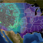
Using Artificial Intelligence to Estimate Traffic to Improve Planning and Access to Colorado’s Public Lands
This project applies data-driven, machine‑learning methods to estimate average annual daily traffic on roads that connect people to Colorado’s public lands, where traffic data are sparse or nonexistent. Expanding on successful applications in Wyoming, the approach uses socioeconomic, land-use, roadway, and accessibility data to uniquely model traffic patterns from 2015 to 2025. These predictions...
Web application development to support decision making and deliver actionable science
FORT web applications support management decisions in the Department of the Interior (DOI) related to management of public lands, invasive species, outdoor recreation, and fish and wildlife health. These applications are developed in partnership with resource managers from Federal, State, local, and Tribal governments, industry, and nongovernmental organizations, empowering local and rural...
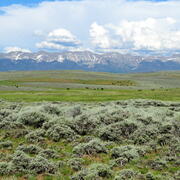
Shrubland, Alpine and Grassland Ecology (SAGE) Wildlife Research Group
The SAGE Wildlife Research Group consists of a large team of research scientists with an interest in conservation and management of wildlife and their ecosystems. Broadly, research involves understanding animal-habitat relationships, with an emphasis on conservation ecology and population demography, and a focus on shrubland, alpine, and grassland ecosystems. We are addressing the effects of...

Developing structured science syntheses for use in NEPA analyses and decision making in the Bureau of Land Management
Science information is fundamental to understanding how proposed actions on public lands may impact the environment. However, agencies often have limited time to compile and synthesize existing science. We are working with land management agencies to develop and explore the usability of a new type of science product— structured science syntheses—for facilitating the use of science information in...
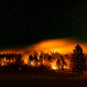
Ecosystem change science in support of wildfire management, water conservation, public land reclamation, and food security
FORT researchers provide sound science to support the Department of the Interior in its efforts to manage wildfires, conserve water, reclaim public lands for multiple uses, and promote food security. This research is developed in partnership with resource managers from local, State, Federal and Tribal governments, industry, and nongovernmental organizations, empowering local and rural communities...

Social and economic analysis research in support of public safety, outdoor recreation, and economic growth
FORT researchers provide sound science to support the Department of the Interior in its efforts to reduce the risks wildfires pose to people and property, expand outdoor recreation and tourism opportunities, and promote economic decision making in public lands management. This research is developed in partnership with resource managers from local, State, Federal and Tribal governments, industry...

Land management research in support of streamlined energy development, economic growth, and wildfire management
FORT researchers provide sound science to support the Department of the Interior in its efforts to streamline reliable energy development, enhance cost efficiency in public lands management, and manage fire-prone habitats for public safety. This research is developed in partnership with resource managers from local, State, Federal and Tribal governments, industry, and nongovernmental organizations...

Fish and wildlife science in support of heritage preservation, efficient decision making, wild ungulate management, and outdoor recreation
FORT researchers provide sound science to support the Department of Interior in its efforts to preserve American heritage, streamline species listing decisions and promote species recovery, manage wild horses and burros using efficient, cost-effective tools, and sustain hunting and fishing on public lands. This research is developed in partnership with resource managers from local, State, Federal...

Economics of Outdoor Recreation
Planning and managing outdoor recreation on public land and water entails a series of choices, many of which are economic in nature. Economics is useful for informing a wide range of decision-making processes in the context of outdoor recreation management, including why people choose to engage in recreation and where, how people substitute between different types of recreation activities and...

Effects of global change on alpine and subalpine ecosystems
Atmospheric nitrogen deposition, changing environmental patterns, and recreation are rapidly altering high elevation ecosystems. This project will evaluate long-term biogeochemical, hydrological, and ecological trends in Rocky Mountain National Park to understand the causes and rates of change in alpine and subalpine waters, soils, and vegetation. Resource managers of high-elevation, protected...

Gunnison Sage-grouse Prioritizing Restoration of Sagebrush Ecosystems Tool (PReSET)
In partnership with the United States Fish and Wildlife Service, and other partners, scientists from USGS Fort Collins Science Center are working to create a suite of prioritization scenarios that will inform adaptive management for Gunnison sage-grouse.