Mountain Pass regional geologic map draped over topography
Mountain Pass regional geologic map draped over topographyGeologic map overlaid on topography for the Mountain Pass region in California.

Official websites use .gov
A .gov website belongs to an official government organization in the United States.
Secure .gov websites use HTTPS
A lock () or https:// means you’ve safely connected to the .gov website. Share sensitive information only on official, secure websites.
Geology, Minerals, Energy, and Geophysics multi-media

Geologic map overlaid on topography for the Mountain Pass region in California.
Geologic map overlaid on topography for the Mountain Pass region in California.

Thin section of a Mountain Pass carbonatite sample showing mineralogy and texture with slider for back-scattered electron map (black and white) and layered elemental map (colored). Note the large, euhedral, tabular crystal of bastnäsite.
Thin section of a Mountain Pass carbonatite sample showing mineralogy and texture with slider for back-scattered electron map (black and white) and layered elemental map (colored). Note the large, euhedral, tabular crystal of bastnäsite.

Isaac Anderson (National Innovation Center) preforms a pre-flight check of a UAS before a photogrammetry mission in post-fire, landslide-prone terrain in Tahoe National Forest.
Isaac Anderson (National Innovation Center) preforms a pre-flight check of a UAS before a photogrammetry mission in post-fire, landslide-prone terrain in Tahoe National Forest.

A UAS flies a photogrammetry mission over recently burned landscapes in Tahoe National Forest.
A UAS flies a photogrammetry mission over recently burned landscapes in Tahoe National Forest.

Isaac Anderson and Liz Hyde (National Innovation Center) bring in a drone for a landing, after flying a photogrammetry mission over landslide-prone terrain recently burned in the Mosquito fire (2022).
Isaac Anderson and Liz Hyde (National Innovation Center) bring in a drone for a landing, after flying a photogrammetry mission over landslide-prone terrain recently burned in the Mosquito fire (2022).

USGS researches and remote pilots coordinate their operations during a break in the action during a photogrammetry flight campaign in post-fire terrain in Tahoe National Forest.
USGS researches and remote pilots coordinate their operations during a break in the action during a photogrammetry flight campaign in post-fire terrain in Tahoe National Forest.

USGS NIC UASRC Saucer Shark equipment marker showing the Saucer flying over trees, with a ‘I WANT TO BELIEVE’ phrase below it.
USGS NIC UASRC Saucer Shark equipment marker showing the Saucer flying over trees, with a ‘I WANT TO BELIEVE’ phrase below it.
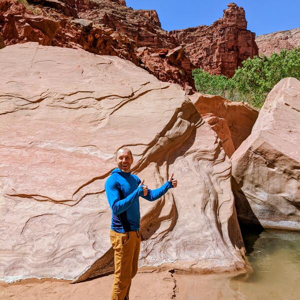
Photograph of Shea Burns in a long sleeve, hooded blue shirt and brown/gold pants, next to the Paria Canyon-Vermillion Cliffs Wilderness
Photograph of Shea Burns in a long sleeve, hooded blue shirt and brown/gold pants, next to the Paria Canyon-Vermillion Cliffs Wilderness

Open pit rare earth element mine at Mountain Pass, California. Stepped sides of the pit and access for mining vehicles are shown.
Open pit rare earth element mine at Mountain Pass, California. Stepped sides of the pit and access for mining vehicles are shown.
Open pit rare earth element mine at Mountain Pass, California. Stepped sides of the pit and access for mining vehicles are shown.
Open pit rare earth element mine at Mountain Pass, California. Stepped sides of the pit and access for mining vehicles are shown.
Research Geologist Jorge Vazquez traveling to Paoha Island, Mono Lake, CA, to collect volcanic rocks
Research Geologist Jorge Vazquez traveling to Paoha Island, Mono Lake, CA, to collect volcanic rocks

Photo of the drone performing a low-altitude gas survey to monitor gas emissions near Mammoth Lakes, CA. In the foreground (the white outcrops) is a fumarole. The dead trees in the background are due to tree-kill from heated ground temperatures
Photo of the drone performing a low-altitude gas survey to monitor gas emissions near Mammoth Lakes, CA. In the foreground (the white outcrops) is a fumarole. The dead trees in the background are due to tree-kill from heated ground temperatures

NASA SSERVI Lunar Regolith Lab's anorthosite mineral test bed located at Moffett Field, California
NASA SSERVI Lunar Regolith Lab's anorthosite mineral test bed located at Moffett Field, California

Steamboat Rock is a basalt "island" left over from the erosion during the glacial Missoula Floods.
Steamboat Rock is a basalt "island" left over from the erosion during the glacial Missoula Floods.

The image shown displays a portion of the lidar data collected by the USGS for the SAFSOC Project. Our goal is to study and map surficial processes and landforms related to tectonism, specifically the San Andreas Fault system.
The image shown displays a portion of the lidar data collected by the USGS for the SAFSOC Project. Our goal is to study and map surficial processes and landforms related to tectonism, specifically the San Andreas Fault system.

The Columbia River flowing through the Hanford reach of the arid Columbia River basin, eastern Washington. This reach is one of the few undammed segments of the Columbia River within the United States. Photograph taken from the White Bluffs, composed of sediment deposited in late Miocene and Pliocene Lake Ringold which occupied the Pasco Basin.
The Columbia River flowing through the Hanford reach of the arid Columbia River basin, eastern Washington. This reach is one of the few undammed segments of the Columbia River within the United States. Photograph taken from the White Bluffs, composed of sediment deposited in late Miocene and Pliocene Lake Ringold which occupied the Pasco Basin.

Hinkley Valley, in the central to western Mojave Desert of southeastern California, has a long historical record owing to its position as a crossroads for rail and road traffic and its position adjacent to the Mojave River.
Hinkley Valley, in the central to western Mojave Desert of southeastern California, has a long historical record owing to its position as a crossroads for rail and road traffic and its position adjacent to the Mojave River.
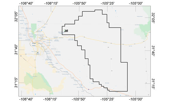
Map indicating flight area for Trans-Pecos aeromagnetic and radiometric survey. The survey area includes parts of El Paso and Hudspeth counties, Texas, and Otero County, New Mexico. Flights will begin in November 2020 and are expected to conclude in mid-January 2021.
Map indicating flight area for Trans-Pecos aeromagnetic and radiometric survey. The survey area includes parts of El Paso and Hudspeth counties, Texas, and Otero County, New Mexico. Flights will begin in November 2020 and are expected to conclude in mid-January 2021.

An enigmatic outcrop of 5 million year old basalt sits 300 meters above the Deschutes and Columbia rivers. USGS scientists are carefully studying this basalt flow to determine if it came all the way from central Oregon, 160 kilometers away.
An enigmatic outcrop of 5 million year old basalt sits 300 meters above the Deschutes and Columbia rivers. USGS scientists are carefully studying this basalt flow to determine if it came all the way from central Oregon, 160 kilometers away.

Geophysical investigations of Mountain Pass, California, were conducted as part of an effort to study regional crustal structures as an aid to understanding the geologic framework and mineral resources of the eastern Mojave Desert. The study area encompasses Mountain Pass, which is host to one of the world’s largest rare earth element (REE) carbonatite deposits.
Geophysical investigations of Mountain Pass, California, were conducted as part of an effort to study regional crustal structures as an aid to understanding the geologic framework and mineral resources of the eastern Mojave Desert. The study area encompasses Mountain Pass, which is host to one of the world’s largest rare earth element (REE) carbonatite deposits.

Looking up at a drone hovering near an open-path methane analyzer mounted on a flux tower. Instruments mounted on both the towers and on the drones are measuring gases emitted from the soil.
Looking up at a drone hovering near an open-path methane analyzer mounted on a flux tower. Instruments mounted on both the towers and on the drones are measuring gases emitted from the soil.