
John Barron is standing in front of some trees with green foliage. He has grey hair and is wearing a purple and blue plaid printed button down, collared shirt and smiling at the camera.
Multimedia
GMEG Multimedia
Images
John Barron Profile picture
John Barron is standing in front of some trees with green foliage. He has grey hair and is wearing a purple and blue plaid printed button down, collared shirt and smiling at the camera.
False color phase map of host breccia from Hicks Dome, Illinois
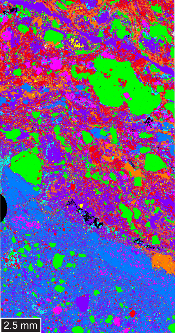
False color phase map of host breccia from Hicks Dome, IllinoisFalse color phase map of host breccia sample from Hicks Dome, Illinois. Image includes the phases of: pyrite, fluorite, quartz, barite-celestite, brookite-anatase, fluorapatite, illite, and dolomite-calcite with Mg-enrichment.
False color phase map of host breccia from Hicks Dome, Illinois
False color phase map of host breccia from Hicks Dome, IllinoisFalse color phase map of host breccia sample from Hicks Dome, Illinois. Image includes the phases of: pyrite, fluorite, quartz, barite-celestite, brookite-anatase, fluorapatite, illite, and dolomite-calcite with Mg-enrichment.
The USGS Cooperative National Geologic Map on smartphone
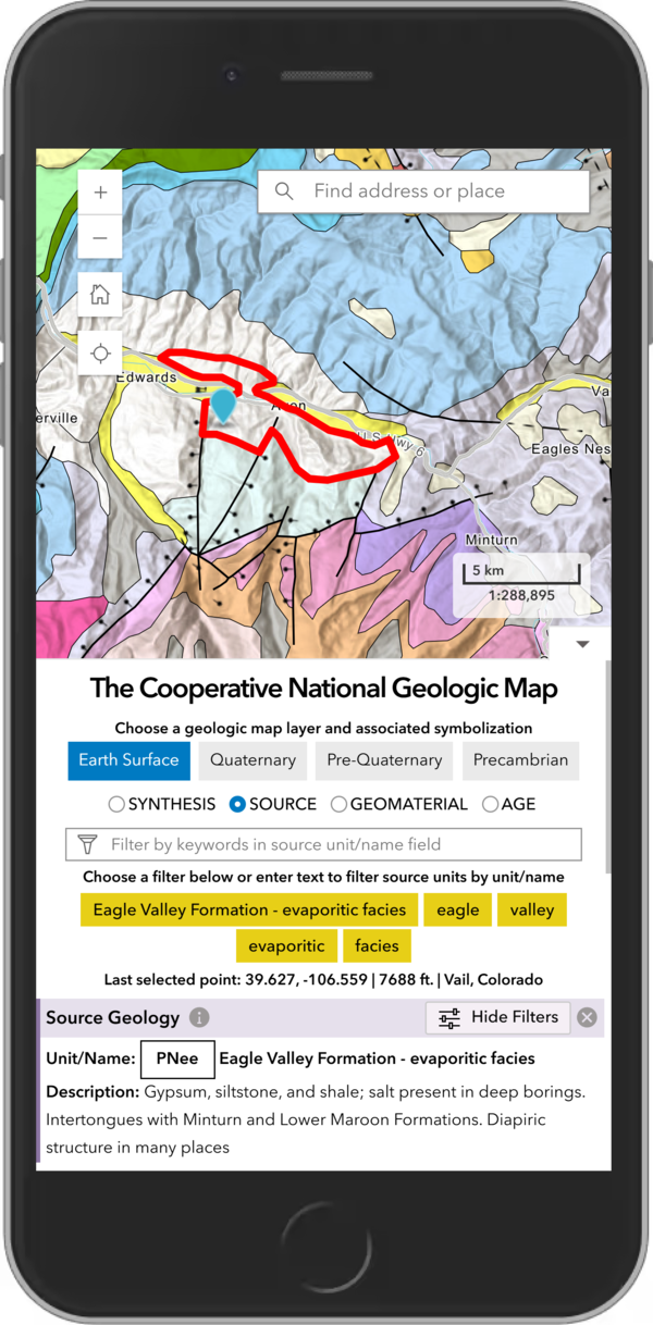
The USGS Cooperative National Geologic Map on smartphoneThe new USGS Cooperative National Geologic Map web tool was designed to also be mobile friendly, allowing users to explore geologic data from smartphones and tablets, in addition to larger devices. USGS image.
The USGS Cooperative National Geologic Map on smartphone
The USGS Cooperative National Geologic Map on smartphoneThe new USGS Cooperative National Geologic Map web tool was designed to also be mobile friendly, allowing users to explore geologic data from smartphones and tablets, in addition to larger devices. USGS image.
Hydrothermal Energy Resources (Illustrated GIF)
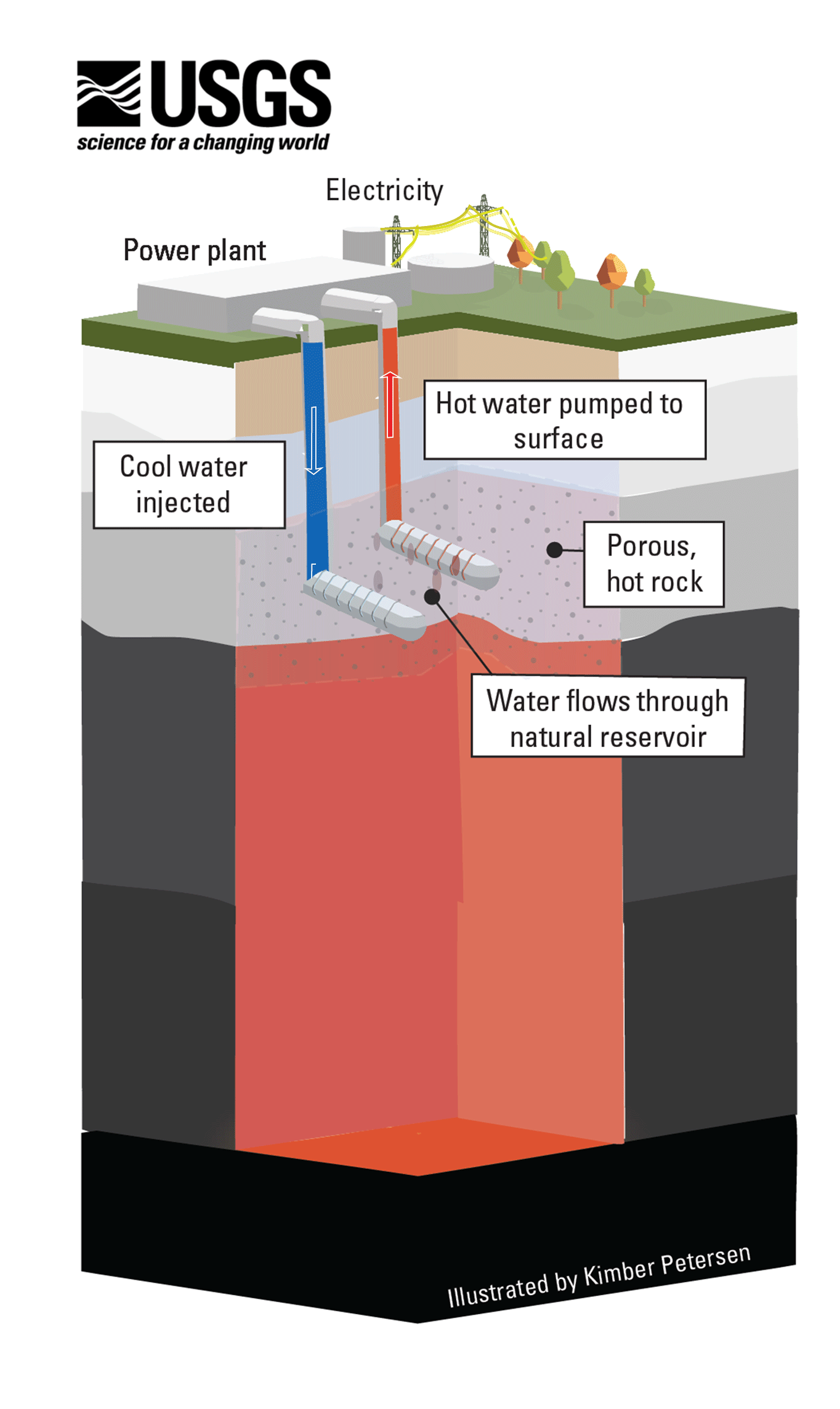
Conventional hydrothermal resources occur below the ground where three ingredients combine: heat, water and permeable rock. When heated water or steam is trapped in a porous rock below a layer of less permeable rock, a hydrothermal reservoir is formed.
Conventional hydrothermal resources occur below the ground where three ingredients combine: heat, water and permeable rock. When heated water or steam is trapped in a porous rock below a layer of less permeable rock, a hydrothermal reservoir is formed.
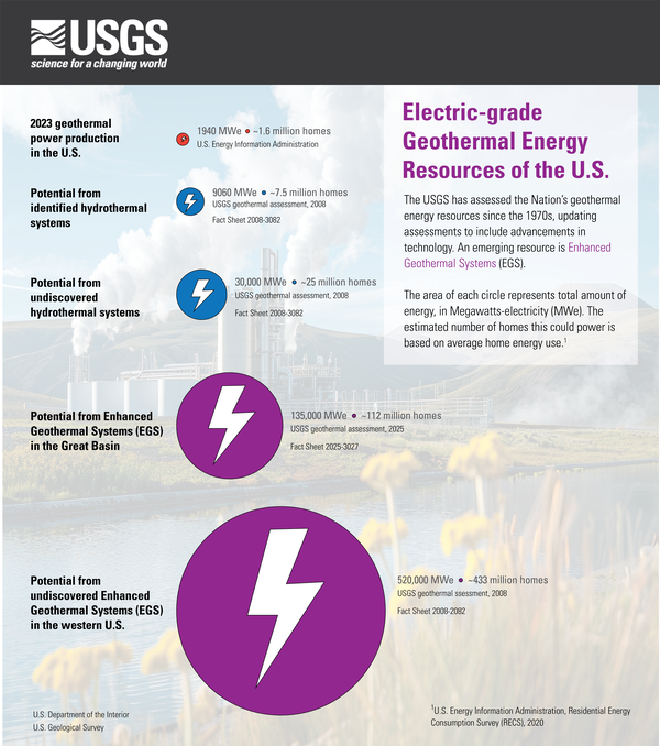
Electric-grade geothermal energy resources of the U.S.
Electric-grade geothermal energy resources of the U.S.Infographic of Electric-grade geothermal energy resources of the U.S.
The USGS has assessed the Nation’s geothermal energy resources since the 1970s, updating assessments to include advancements in technology. An emerging resource is Enhanced Geothermal Systems (EGS).
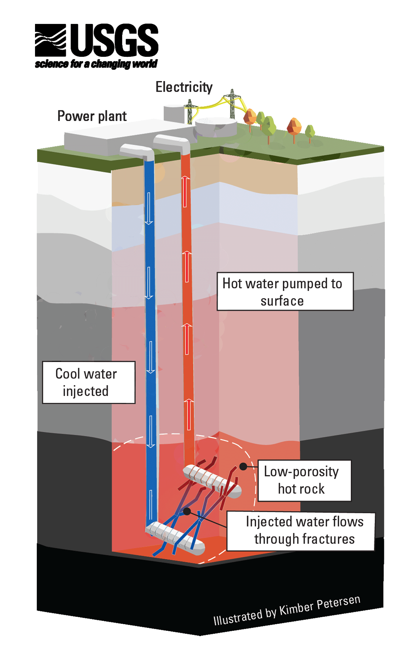
Enhanced Geothermal Systems (Illustrated GIF)
Enhanced Geothermal Systems are an emerging resource that the USGS studies. To generate electricity from these systems, fractures are engineered into deep, low-porosity hot rocks to allow water to circulate. Then, the heated water is pumped back to the surface, where the thermal energy is used to move a turbine and generate electricity.
Enhanced Geothermal Systems are an emerging resource that the USGS studies. To generate electricity from these systems, fractures are engineered into deep, low-porosity hot rocks to allow water to circulate. Then, the heated water is pumped back to the surface, where the thermal energy is used to move a turbine and generate electricity.
Videos

Measuring natural methane emissions from bogs using drones in Alaska B-Roll
Measuring natural methane emissions from bogs using drones in Alaska B-RollPermafrost is ground that has been frozen for at least two years. With the warming climate, permafrost across Alaska is thawing and greenhouse gases such as methane are released as a result. Ecologist Kristen Manies of the U.S.

A Record of Change: Science and Elder Observations on the Navajo N.
A Record of Change: Science and Elder Observations on the Navajo N.A Record of Change—Science and Elder Observations on the Navajo Nation is a 25-minute documentary about collaborative studies using conventional physical sciences, combined with tribal elder observations to show that local knowledge and conventional science partnerships can effectively document ecosystem change and determine the resulting challenges to livelihoods.&

PubTalk 10/2016 — Rockfalls in California's Sierra Nevada
PubTalk 10/2016 — Rockfalls in California's Sierra NevadaRock falls in California’s Sierra Nevada - Pursuing explanations for exfoliation and seemingly spontaneous fracture of rock
PubTalk 10/2016 — Rockfalls in California's Sierra Nevada
PubTalk 10/2016 — Rockfalls in California's Sierra NevadaRock falls in California’s Sierra Nevada - Pursuing explanations for exfoliation and seemingly spontaneous fracture of rock