
Toronto's skyline at sunset from Humber Bay in Lake Ontario. Photo credit: Alden Tilley, USGS.
Images
Images captured by GLSC scientists while working in and around the Great Lakes.
Filter Total Items: 494

Toronto at Sunset from Humber Bay
Toronto's skyline at sunset from Humber Bay in Lake Ontario. Photo credit: Alden Tilley, USGS.

Late Night Ahead
USGS marine maintenance repairer and ship operator (GLSC; Cheboygan, Michigan) ready the trawl doors at sunset as the R/V Sturgeon heads out for a night of work to search for ciscos (Coregonus artedi) on Lake Huron. Photo credit: Patty Dieter, USGS.
USGS marine maintenance repairer and ship operator (GLSC; Cheboygan, Michigan) ready the trawl doors at sunset as the R/V Sturgeon heads out for a night of work to search for ciscos (Coregonus artedi) on Lake Huron. Photo credit: Patty Dieter, USGS.
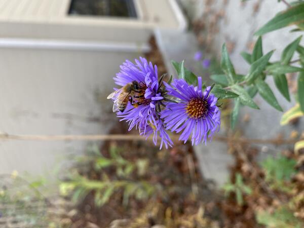
Well I’ll Bee Leaving my DNA
A honey bee (genus Apis) observed visiting an aster; a great observation for potential environmental DNA that can be recovered. Photo credit: Leslie Reyes, USGS Contractor.
A honey bee (genus Apis) observed visiting an aster; a great observation for potential environmental DNA that can be recovered. Photo credit: Leslie Reyes, USGS Contractor.

Sturgeon Under the Bridge
The GLSC’s R/V Sturgeon leaves Charlevoix, Michigan at the end of a lake trout spawner gillnet survey on Lake Michigan to head home to the Cheboygan Vessel Base (GLSC; Cheboygan, Michigan). Photo credit: Patty Dieter, USGS.
The GLSC’s R/V Sturgeon leaves Charlevoix, Michigan at the end of a lake trout spawner gillnet survey on Lake Michigan to head home to the Cheboygan Vessel Base (GLSC; Cheboygan, Michigan). Photo credit: Patty Dieter, USGS.

Toss the Flag
A USGS technician (GLSC; Ann Arbor, Michigan) throws the gillnet buoy flag overboard during a fall gillnet survey on Lake Michigan aboard the GLSC’s R/V Sturgeon. Photo credit: Patty Dieter, USGS.
A USGS technician (GLSC; Ann Arbor, Michigan) throws the gillnet buoy flag overboard during a fall gillnet survey on Lake Michigan aboard the GLSC’s R/V Sturgeon. Photo credit: Patty Dieter, USGS.

Untangling Lake Trout Like a Boss
USGS science staff (GLSC; Ann Arbor, Michigan) and vessel crewmembers (GLSC; Cheboygan, Michigan) picking lake trout (Salvelinus namaycush) out of a gillnet during the 2023 Lake Michigan Northern Refuge lake trout spawner survey aboard the GLSC’s R/V Sturgeon. Photo credit: Ben Leonhardt, USGS.
USGS science staff (GLSC; Ann Arbor, Michigan) and vessel crewmembers (GLSC; Cheboygan, Michigan) picking lake trout (Salvelinus namaycush) out of a gillnet during the 2023 Lake Michigan Northern Refuge lake trout spawner survey aboard the GLSC’s R/V Sturgeon. Photo credit: Ben Leonhardt, USGS.
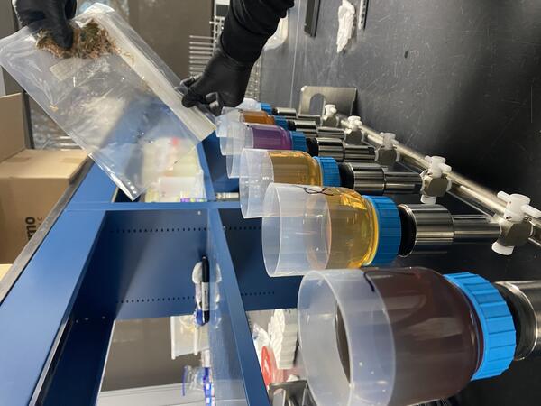
Filter the Rainbow
Colorful elutriates (washings) from processed fresh flower samples as part of a Bipartisan Infrastructure Law-funded pollinator project (GLSC; Chesterton, Indiana). Photo credit: Leslie Reyes, USGS Contractor.
Colorful elutriates (washings) from processed fresh flower samples as part of a Bipartisan Infrastructure Law-funded pollinator project (GLSC; Chesterton, Indiana). Photo credit: Leslie Reyes, USGS Contractor.

Brisk Morning Air
Two USGS science technicians (GLSC; Ann Arbor, Michigan) and the ship operator (GLSC; Cheboygan, Michigan) take in the early morning scenery as the R/V Sturgeon heads out for a day of setting gillnets in the Northern Refuge of Lake Michigan. Photo credit: Patty Dieter, USGS.
Two USGS science technicians (GLSC; Ann Arbor, Michigan) and the ship operator (GLSC; Cheboygan, Michigan) take in the early morning scenery as the R/V Sturgeon heads out for a day of setting gillnets in the Northern Refuge of Lake Michigan. Photo credit: Patty Dieter, USGS.
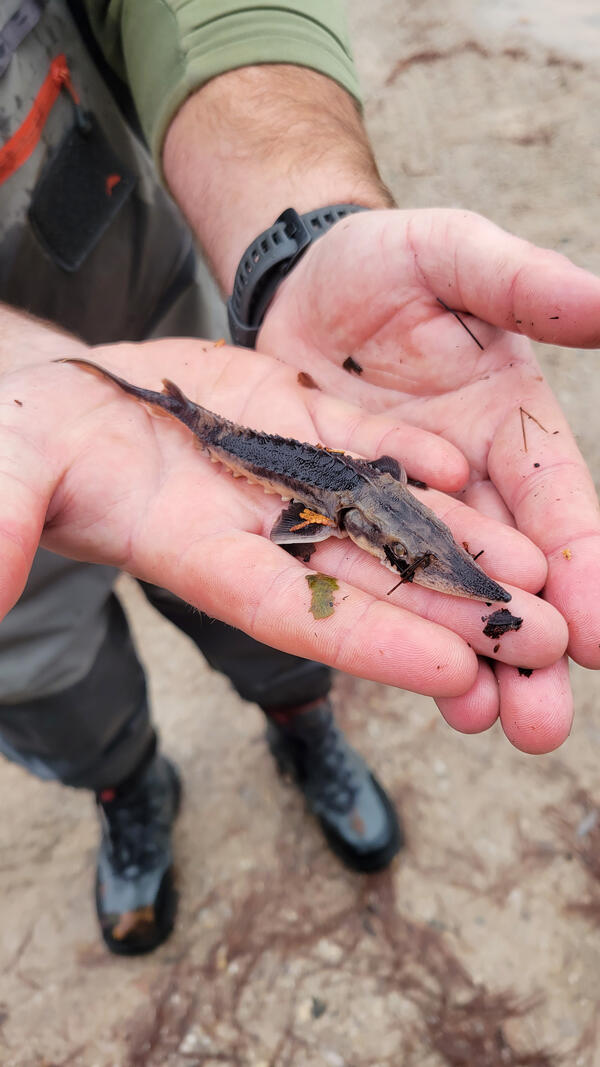
Juvenile Lake Sturgeon
Juvenile lake sturgeon (Acipenser fulvescens) caught in a sea lamprey net in November 2023 in the Sturgeon River in northern Michigan. Photo credit: Ed Benzer, USGS.
Juvenile lake sturgeon (Acipenser fulvescens) caught in a sea lamprey net in November 2023 in the Sturgeon River in northern Michigan. Photo credit: Ed Benzer, USGS.
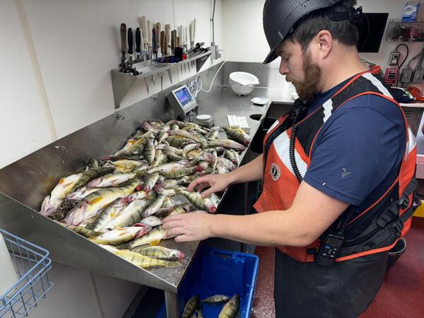
Sorting Fish
A USGS research fisheries biologist (GLSC; Ann Arbor, Michigan) examines the catch from waters around Goderich, Ontario during the Lake Huron fall prey fish survey aboard the GLSC’s R/V Sturgeon. Photo credit: Kristy Phillips, USGS.
A USGS research fisheries biologist (GLSC; Ann Arbor, Michigan) examines the catch from waters around Goderich, Ontario during the Lake Huron fall prey fish survey aboard the GLSC’s R/V Sturgeon. Photo credit: Kristy Phillips, USGS.
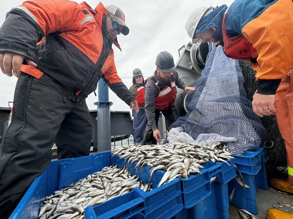
First Tow of Lake Huron Fall Prey Fish Survey
USGS vessel crewmembers (GLSC; Cheboygan, Michigan) and science staff (GLSC; Ann Arbor, Michigan) aboard the GLSC’s R/V Sturgeon open the cod end of a full bottom trawl net to examine the catch during an annual Lake Huron fall prey fish survey. Photo credit: Kristy Phillips, USGS.
USGS vessel crewmembers (GLSC; Cheboygan, Michigan) and science staff (GLSC; Ann Arbor, Michigan) aboard the GLSC’s R/V Sturgeon open the cod end of a full bottom trawl net to examine the catch during an annual Lake Huron fall prey fish survey. Photo credit: Kristy Phillips, USGS.

Falls in the Fall
A fall day at the Tahquamenon Upper Falls, Michigan. Photo credit: Cory Brant, USGS.
A fall day at the Tahquamenon Upper Falls, Michigan. Photo credit: Cory Brant, USGS.

Whitefish Point Rocks
The mysterious rocks and shoreline of Whitefish Point, Lake Superior. Photo credit: Cory Brant, USGS.
The mysterious rocks and shoreline of Whitefish Point, Lake Superior. Photo credit: Cory Brant, USGS.
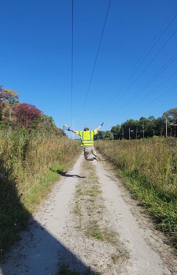
Soaring for Science
A USGS intern (GLSC; Chesterton, Indiana) jumping high with his bag of recently collected flower samples. Photo credit: Jessica Oswald, USGS Contractor.
A USGS intern (GLSC; Chesterton, Indiana) jumping high with his bag of recently collected flower samples. Photo credit: Jessica Oswald, USGS Contractor.

Dynamic Duo
USGS researchers (GLSC; Chesterton, Indiana) spiking chrysanthemums with DNA prior to a simulated rainfall as part of an environmental DNA degradation experiment. Photo credit: Zachary Hatfield, USGS Contractor.
USGS researchers (GLSC; Chesterton, Indiana) spiking chrysanthemums with DNA prior to a simulated rainfall as part of an environmental DNA degradation experiment. Photo credit: Zachary Hatfield, USGS Contractor.
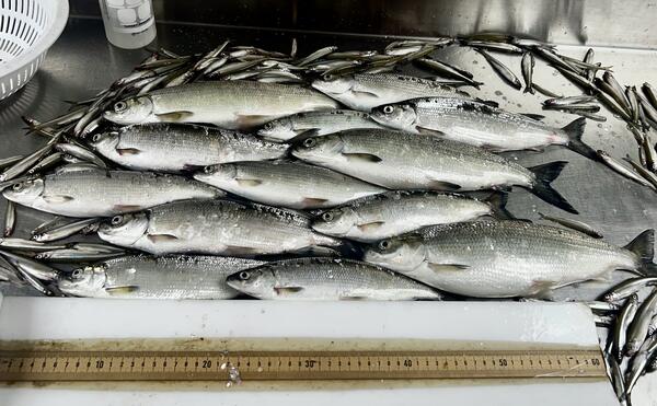
Artedi on Board
Cisco (Coregonus artedi) and an assortment of prey fish caught in the North Channel of Lake Huron. Photo credit: Kristy Phillips, USGS.
Cisco (Coregonus artedi) and an assortment of prey fish caught in the North Channel of Lake Huron. Photo credit: Kristy Phillips, USGS.
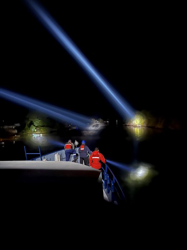
Navigator
USGS Cheboygan Vessel Base crew (GLSC; Cheboygan, Michigan) and GLSC science staff (Ann Arbor, Michigan) assist the R/V Sturgeon vessel captain through dark waters of the Byng Inlet after completing a long night of hydro-acoustic survey work in Georgian Bay, Canada. Photo credit: Kristy Phillips, USGS.
USGS Cheboygan Vessel Base crew (GLSC; Cheboygan, Michigan) and GLSC science staff (Ann Arbor, Michigan) assist the R/V Sturgeon vessel captain through dark waters of the Byng Inlet after completing a long night of hydro-acoustic survey work in Georgian Bay, Canada. Photo credit: Kristy Phillips, USGS.
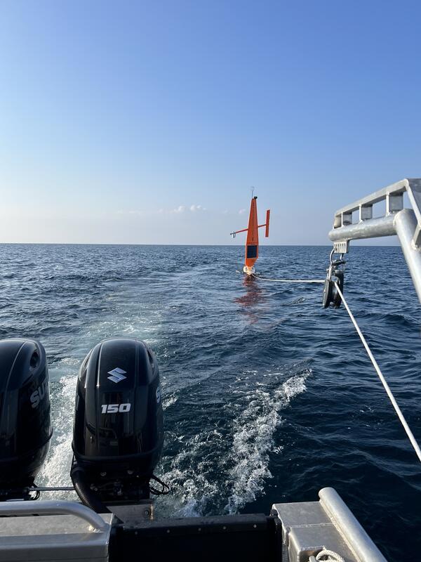
Drone Tow
USGS researchers (GLSC; Ann Arbor, Michigan) tow an uncrewed, wind- and solar-powered vehiclethrough the Mississagi Strait in Lake Huron with the R/V Desmid for field sampling. Photo credit: Nick Yeager, USGS.
USGS researchers (GLSC; Ann Arbor, Michigan) tow an uncrewed, wind- and solar-powered vehiclethrough the Mississagi Strait in Lake Huron with the R/V Desmid for field sampling. Photo credit: Nick Yeager, USGS.

Tuggin' Along
A USGS wetland scientist (GLSC; Ann Arbor, Michigan) pulls a small boat containing cut, invasive Phragmites australis during wetlands field work at Metzger Marsh on the shore of Lake Erie in Ohio. Photo credit: Anthony Rondon, USGS.
A USGS wetland scientist (GLSC; Ann Arbor, Michigan) pulls a small boat containing cut, invasive Phragmites australis during wetlands field work at Metzger Marsh on the shore of Lake Erie in Ohio. Photo credit: Anthony Rondon, USGS.

Love is in the Air
A pair of differential grasshoppers (Mellanoplus differentialis) mating on an invasive Phragmites australis plant within an experimental plot. Photo credit: Spenser Widin, USGS.
A pair of differential grasshoppers (Mellanoplus differentialis) mating on an invasive Phragmites australis plant within an experimental plot. Photo credit: Spenser Widin, USGS.

Surprise Catch
A juvenile lake sturgeon (Acipenser fulvescens) captured during a bottom trawl survey in Lake Erie aboard the GLSC’s R/V Muskie. Photo credit: Kevin Keretz, USGS.
A juvenile lake sturgeon (Acipenser fulvescens) captured during a bottom trawl survey in Lake Erie aboard the GLSC’s R/V Muskie. Photo credit: Kevin Keretz, USGS.