
Hydrologic technician wades into the St John River in Allagash, Maine near the Dickey streamgage 01010500 stringing a tag line in the early morning.
Images
Click through our gallery of photographs showcasing New England Water Science Center research projects and monitoring work throughout the region.
Filter Total Items: 601

The rocky shore of a fog covered river in Maine
Hydrologic technician wades into the St John River in Allagash, Maine near the Dickey streamgage 01010500 stringing a tag line in the early morning.

A small rocky stream surrounded by fall foliage
Little River near Oxford, Massachusetts near the USGS gage 01124500 location. Fall colors beginning to turn on the Little River.
Little River near Oxford, Massachusetts near the USGS gage 01124500 location. Fall colors beginning to turn on the Little River.

River during the fall
Farmington River near Riverton, Connecticut during the fall. Photo was taken off of a bridge.
Farmington River near Riverton, Connecticut during the fall. Photo was taken off of a bridge.

Streamgage mounted in the rocky bank of a raging river
Streamgage mounted in the rocky bank of a raging riverDead River at USGS gage 01043500 site in Dead River, Maine during a scheduled high-flow dam release. The outflow from this dam at Flagstaff Lake, Maine is the head water of the Dead River.
Streamgage mounted in the rocky bank of a raging river
Streamgage mounted in the rocky bank of a raging riverDead River at USGS gage 01043500 site in Dead River, Maine during a scheduled high-flow dam release. The outflow from this dam at Flagstaff Lake, Maine is the head water of the Dead River.

View of Essex Island Marina during water quality sample collection
View of Essex Island Marina during water quality sample collectionView of Essex Island Marina during discrete water quality sample collection near 01194750 location.
View of Essex Island Marina during water quality sample collection
View of Essex Island Marina during water quality sample collectionView of Essex Island Marina during discrete water quality sample collection near 01194750 location.

Hydrologic technician servicing continuous water quality monitor
Hydrologic technician servicing continuous water quality monitorHydrologic technician servicing continuous water quality monitor at Mystic River US Route I-95 Bridge near Old Mystic, Connecticut, (USGS site ID 412240071574700)
Hydrologic technician servicing continuous water quality monitor
Hydrologic technician servicing continuous water quality monitorHydrologic technician servicing continuous water quality monitor at Mystic River US Route I-95 Bridge near Old Mystic, Connecticut, (USGS site ID 412240071574700)

Servicing continuous water quality monitor
Hydrologic technician servicing continuous water quality monitor at Mystic Harbor at Safe Harbor Marina near Mystic, Connecticut (USGS site ID 412240071580800)
Hydrologic technician servicing continuous water quality monitor at Mystic Harbor at Safe Harbor Marina near Mystic, Connecticut (USGS site ID 412240071580800)

Kenduskeag Stream Gaging Station
USGS gaging station on the Kenduskeag Stream near Bangor, Maine, station 01037000. This station is downstream of Six Mile Falls, a popular spot during the Kenduskeag Canoe Race.
USGS gaging station on the Kenduskeag Stream near Bangor, Maine, station 01037000. This station is downstream of Six Mile Falls, a popular spot during the Kenduskeag Canoe Race.

Continuous water quality station
Continuous water quality station on the Mystic River at the Mystic Seaport, Mystic Connecticut (Site ID 412141071580200). Setup includes top and bottom multiparameter sondes and velocity uplooker.
Continuous water quality station on the Mystic River at the Mystic Seaport, Mystic Connecticut (Site ID 412141071580200). Setup includes top and bottom multiparameter sondes and velocity uplooker.


A tide gage, Wickford, Rhode Island
A tide gage that measures water levels at 5-minute intervals installed in Academy Cove in 2021. Wickford, Rhode Island.
A tide gage that measures water levels at 5-minute intervals installed in Academy Cove in 2021. Wickford, Rhode Island.

Stratified Sand
Stratified sand in an excavation near the Connecticut River in Portland, Connecticut. The sand was deposited as a delta in a glacial lake that occupied the Connecticut River Valley about 18,000-19,000 years ago.
Stratified sand in an excavation near the Connecticut River in Portland, Connecticut. The sand was deposited as a delta in a glacial lake that occupied the Connecticut River Valley about 18,000-19,000 years ago.

Collecting discrete water quality samples
Hydrologic technicians collecting discrete water quality samples at Norwalk River at Ferry Point near Norwalk, Connecticut (USGS Site ID 410643073243700)
Hydrologic technicians collecting discrete water quality samples at Norwalk River at Ferry Point near Norwalk, Connecticut (USGS Site ID 410643073243700)


High flow event at Mount Hope River near Warrenville, CT
High flow event at Mount Hope River near Warrenville, CTHigh flow event at Mount Hope River near Warrenville, CT (USGS station 01121000).
High flow event at Mount Hope River near Warrenville, CT
High flow event at Mount Hope River near Warrenville, CTHigh flow event at Mount Hope River near Warrenville, CT (USGS station 01121000).

Yukon River Near Stevens Village, Alaska
Landsat image of the Yukon River near Stevens Village, Alaska collected on July 8, 2021.
Landsat image of the Yukon River near Stevens Village, Alaska collected on July 8, 2021.

Taking a water sample in Green River
Photo Contest Winner | July 2021 | Honorable Mention 1
Taking a water sample in Green River
Photo Contest Winner | July 2021 | Honorable Mention 1
Taking a water sample in Green River

Continuous water quality gaging station at Norwalk Harbor, Connecticut
Continuous water quality gaging station at Norwalk Harbor, ConnecticutContinuous water quality gaging station located at Norwalk Harbor at the Cove Marina near East Norwalk, Connecticut (USGS site ID 410502073236000)
Continuous water quality gaging station at Norwalk Harbor, Connecticut
Continuous water quality gaging station at Norwalk Harbor, ConnecticutContinuous water quality gaging station located at Norwalk Harbor at the Cove Marina near East Norwalk, Connecticut (USGS site ID 410502073236000)

Inspecting the gage equipment
New England WSC hydrologic technician inspecting the gage equipment at 410606073245700, Norwalk River at the Norwalk Aquarium.
New England WSC hydrologic technician inspecting the gage equipment at 410606073245700, Norwalk River at the Norwalk Aquarium.
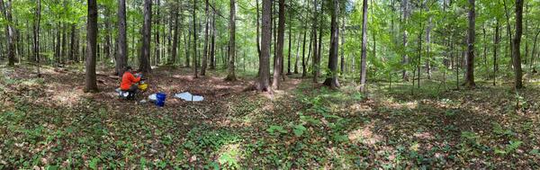
Shallow Soil Sampling for PFAS in New Hampshire
USGS staff take a soil sample from a collection site in New Hampshire. The shallow soils were collected as part of a statewide monitoring effort to identify the prevalence of "background" PFAS in the environment, or PFAS presence that did not come from a clearly identifiable source.
USGS staff take a soil sample from a collection site in New Hampshire. The shallow soils were collected as part of a statewide monitoring effort to identify the prevalence of "background" PFAS in the environment, or PFAS presence that did not come from a clearly identifiable source.

Kennebec River at The Forks
The view from the river of the USGS gaging station on the Kennebec River at The Forks, station 01042500 during summer.
The view from the river of the USGS gaging station on the Kennebec River at The Forks, station 01042500 during summer.