2020 drought impact on Stony Brook near West Suffield, Connecticut
2020 drought impact on Stony Brook near West Suffield, ConnecticutStation 01184100 Stony Brook near West Suffield, Connecticut.

Official websites use .gov
A .gov website belongs to an official government organization in the United States.
Secure .gov websites use HTTPS
A lock () or https:// means you’ve safely connected to the .gov website. Share sensitive information only on official, secure websites.
Click through our gallery of photographs showcasing New England Water Science Center research projects and monitoring work throughout the region.

Station 01184100 Stony Brook near West Suffield, Connecticut.
Station 01184100 Stony Brook near West Suffield, Connecticut.

Station 01196588 Mill River at Cook Hill Rd. in Cheshire, Connecticut.
Photo shows dry river channel at location of staff gage.
Station 01196588 Mill River at Cook Hill Rd. in Cheshire, Connecticut.
Photo shows dry river channel at location of staff gage.

2020 drought impact on Sudbury River near the USGS station 01098530 in Saxonville, Massachusetts
2020 drought impact on Sudbury River near the USGS station 01098530 in Saxonville, Massachusetts

2020 drought impact on Segreganset River near USGS station 01109070, Dighton, Massachusetts
2020 drought impact on Segreganset River near USGS station 01109070, Dighton, Massachusetts

Quinebaug River near West Thompson, Connecticut. Photo shows one of few deeper pools of water in the 01124151 station vicinity during drought.
Quinebaug River near West Thompson, Connecticut. Photo shows one of few deeper pools of water in the 01124151 station vicinity during drought.

Station 01124151 Quinebaug River West Thompson Connecticut. The photo shows the orifice line that senses the river stage. The orifice is out of water, so we were not able to collect stage or discharge data.
Station 01124151 Quinebaug River West Thompson Connecticut. The photo shows the orifice line that senses the river stage. The orifice is out of water, so we were not able to collect stage or discharge data.

Two USGS scientists traveling by boat to estuary sampling and monitoring stations, Merrimack River, Massachusetts
Two USGS scientists traveling by boat to estuary sampling and monitoring stations, Merrimack River, Massachusetts

USGS hydrologist collecting water samples with a Van Dorn sampler on the Merrimack River, Massachusetts.
USGS hydrologist collecting water samples with a Van Dorn sampler on the Merrimack River, Massachusetts.

Merrimack River near Aiken St Bridge, Lowell, Massachusetts (USGS ID: 010965985).
The site is one of the Merrimack project water quality sampling and monitoring stations.
Merrimack River near Aiken St Bridge, Lowell, Massachusetts (USGS ID: 010965985).
The site is one of the Merrimack project water quality sampling and monitoring stations.

A vibrant photograph of the Connecticut River and surrounding landscape. The River is bordered by farm fields with mountains in the distance. The image was taken from Mount Sugarloaf in South Deerfield, MA.
A vibrant photograph of the Connecticut River and surrounding landscape. The River is bordered by farm fields with mountains in the distance. The image was taken from Mount Sugarloaf in South Deerfield, MA.

USGS gage 422302071083801 Fresh Pond in Gate House at Cambridge, Massachusetts.
USGS gage 422302071083801 Fresh Pond in Gate House at Cambridge, Massachusetts.

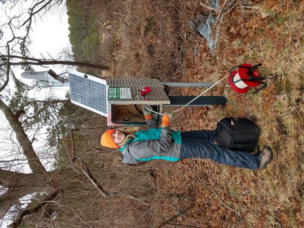
USGS employee Sam Banas adjusting a solar panel and installing real-time equipment onto a groundwater well.
USGS employee Sam Banas adjusting a solar panel and installing real-time equipment onto a groundwater well.

Hydrologic technician measured the streamflow of ice-covered rivers in Northern Maine as part of the North Index Trip. Certain gages are considered "Index" sites because they make for good references when comparing discharges of nearby streamgages, especially in frozen conditions.
Hydrologic technician measured the streamflow of ice-covered rivers in Northern Maine as part of the North Index Trip. Certain gages are considered "Index" sites because they make for good references when comparing discharges of nearby streamgages, especially in frozen conditions.

Photo Contest Winner | March 2020 | People
Surveyors Road
Photo Contest Winner | March 2020 | People
Surveyors Road
A Geoscientist-in-the-Park Guest Scientist for the National Park Service services a USGS groundwater well located within the Mill Creek basin near the Herring River in Wellfleet, Massachusetts.
A Geoscientist-in-the-Park Guest Scientist for the National Park Service services a USGS groundwater well located within the Mill Creek basin near the Herring River in Wellfleet, Massachusetts.

Hydrologic technician adjusting a solar panel while installing new real-time equipment and gage house onto a groundwater well. The site ID is: 423715072042801 MA-TMW 3R TEMPLETON, MA.
Hydrologic technician adjusting a solar panel while installing new real-time equipment and gage house onto a groundwater well. The site ID is: 423715072042801 MA-TMW 3R TEMPLETON, MA.

Assessing the variability of arsenic over multiple time scales project.
Collection samples hourly at a private domestic bedrock well, Seabrook, New Hampshire.
Assessing the variability of arsenic over multiple time scales project.
Collection samples hourly at a private domestic bedrock well, Seabrook, New Hampshire.

Northeast Region Photo Contest, August 2019, Honorable Mention
Hydro tech, Alex Wong, collecting stream flow data
Northeast Region Photo Contest, August 2019, Honorable Mention
Hydro tech, Alex Wong, collecting stream flow data

Photo showing monitoring wells adjacent to Sailfish Drive, Falmouth, Massachusetts.
Photo showing monitoring wells adjacent to Sailfish Drive, Falmouth, Massachusetts.

Photo Contest Winner | Nov. 2019 | USGS at Work
Randy Orndorff examines limestone on Lake Champlain, VT
Photo Contest Winner | Nov. 2019 | USGS at Work
Randy Orndorff examines limestone on Lake Champlain, VT

Tuckerman Ravine on the southeast face of Mt. Washington in White Mountains, New Hampshire covered in snow.
Tuckerman Ravine on the southeast face of Mt. Washington in White Mountains, New Hampshire covered in snow.