
The water quality sample is being taken at Saugatuck River near Westport, CT 01209500.
Images
Click through our gallery of photographs showcasing New England Water Science Center research projects and monitoring work throughout the region.
Filter Total Items: 601

Taking the water quality sample
The water quality sample is being taken at Saugatuck River near Westport, CT 01209500.


Otter Brook State Park, Keene, New Hampshire
Field team took advantage of a warmer winter day and stopped on their way between sites to eat a socially distanced lunch at Otter Brook State Park, managed by the Army Corps of Engineers.
Field team took advantage of a warmer winter day and stopped on their way between sites to eat a socially distanced lunch at Otter Brook State Park, managed by the Army Corps of Engineers.


Panoramic view of the streamgage location surroundings during winter
Panoramic view of the streamgage location surroundings during winterPanoramic view of the USGS streamgage 011230695 (Shetucket River) surroundings during a grey, snowy day.
Panoramic view of the streamgage location surroundings during winter
Panoramic view of the streamgage location surroundings during winterPanoramic view of the USGS streamgage 011230695 (Shetucket River) surroundings during a grey, snowy day.


Streamgage 0110588340 Barnstable, MA
Streamgage location (0110588340) on the Santuit River at Old Kings Road, Barnstable MA.
Streamgage location (0110588340) on the Santuit River at Old Kings Road, Barnstable MA.

Railroad bridge spans the White River, Royalton, Vermont
Railroad bridge spans the White River, Royalton, VermontCirca 1928 railroad bridge spans the White River, Royalton, Vermont. This bridge is one of dozens the applied hydrology surveying unit surveyed for modelers for new flood inundation models. The model data are then used to produce flood insurance rate maps for Federal Emergency Management Agency (FEMA).

USGS boat ready to collect water samples
USGS boat used to collect water samples in a PFAS-impacted lake on Cape Cod.
USGS boat used to collect water samples in a PFAS-impacted lake on Cape Cod.
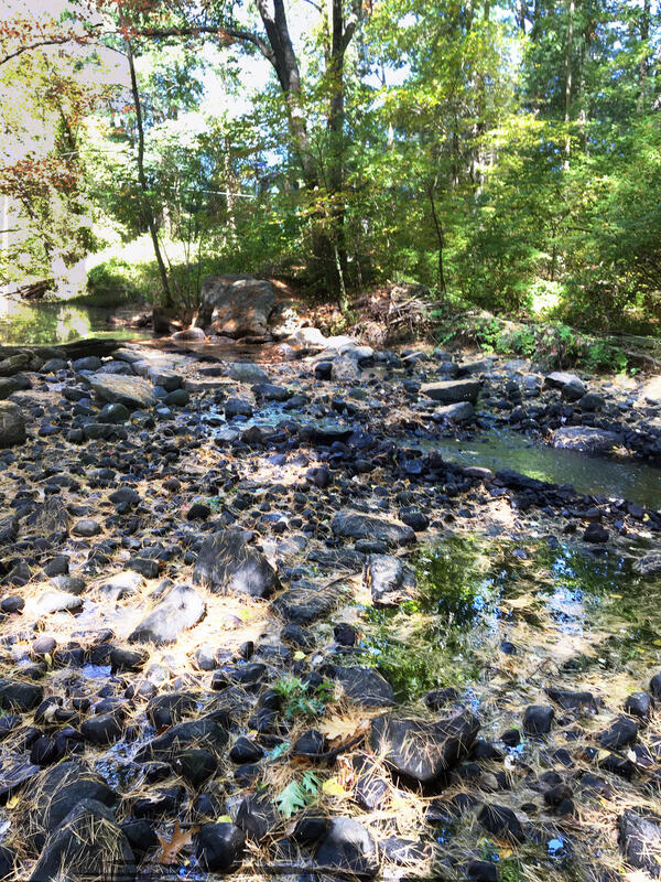
2020 drought impact on Little River near Oxford, Massachusetts
2020 drought impact on Little River near Oxford, Massachusetts2020 drought impact on Little River near the USGS station 01124500 near Oxford, Massachusetts
2020 drought impact on Little River near Oxford, Massachusetts
2020 drought impact on Little River near Oxford, Massachusetts2020 drought impact on Little River near the USGS station 01124500 near Oxford, Massachusetts

Behind the Total Station
Surface Water Modeling for FEMA Flood Insurance Rate Maps.
Hydrologic Technician Gunther Schletter takes a channel measurement using a Total Station on a river near St. Johnsbury, VT.
Surface Water Modeling for FEMA Flood Insurance Rate Maps.
Hydrologic Technician Gunther Schletter takes a channel measurement using a Total Station on a river near St. Johnsbury, VT.

Taking channel measurements from a canoe
Surface Water Modeling for FEMA Flood Insurance Rate Maps.
USGS employee in a canoe hold a prism and survey rod level while the channel point is collected with a total station from shore.
Surface Water Modeling for FEMA Flood Insurance Rate Maps.
USGS employee in a canoe hold a prism and survey rod level while the channel point is collected with a total station from shore.

2020 drought impact on Cochituate Brook at Framingham, Massachusetts
2020 drought impact on Cochituate Brook at Framingham, MassachusettsThe New England Water Science Center continuously monitors the status of New England's principal rivers, reservoirs, and aquifers to compare current hydrologic conditions with normal and extreme recorded values. Displayed on the photo is a drought impact on Cochituate Brook at Framingham, Massachusetts.

Collecting cross-section data for flood surveying
Hydrologic technician using a GPS receiver to collect cross-section data for flood surveying on Otter Creek in Rutland, Vermont. A covered bridge is in the background.
Hydrologic technician using a GPS receiver to collect cross-section data for flood surveying on Otter Creek in Rutland, Vermont. A covered bridge is in the background.

Recording water-quality field parameters
USGS hydrologist and a grad student from University of Massachusetts Lowell recording water-quality field parameters on the Merrimack River, Massachusetts.
USGS hydrologist and a grad student from University of Massachusetts Lowell recording water-quality field parameters on the Merrimack River, Massachusetts.

Merrimack River estuary in Salisbury, Massachusetts
Merrimack River estuary in Salisbury, MassachusettsMerrimack River estuary in Salisbury, Massachusetts. The view is from the Salisbury Beach State Reservation boat ramp looking south. The red pyramid is the "Butler Toothpick", the US Coast Guard Day Beacon 10.

2020 drought - Pendleton Hill Brook near Clarks Falls, Connecticut
2020 drought - Pendleton Hill Brook near Clarks Falls, ConnecticutStation 01118300 Pendleton Hill Brook near Clarks Falls, Connecticut.
Photo shows zero flow, just standing water, during 2020 drought.
2020 drought - Pendleton Hill Brook near Clarks Falls, Connecticut
2020 drought - Pendleton Hill Brook near Clarks Falls, ConnecticutStation 01118300 Pendleton Hill Brook near Clarks Falls, Connecticut.
Photo shows zero flow, just standing water, during 2020 drought.

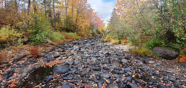
Stony Brook near West Suffield, Connecticut during 2020 drought
Stony Brook near West Suffield, Connecticut during 2020 droughtStation 01184100 Stony Brook near West Suffield, Connecticut.
Stony Brook near West Suffield, Connecticut during 2020 drought
Stony Brook near West Suffield, Connecticut during 2020 droughtStation 01184100 Stony Brook near West Suffield, Connecticut.