
Hydrologic technician drilling a hole in the ice with an ice auger on the Housatonic River, Massachusetts near the USGS streamgage 01198125. This hole will be used to safely collect a water quality sample from the ice.
Images
Click through our gallery of photographs showcasing New England Water Science Center research projects and monitoring work throughout the region.
Filter Total Items: 601

Drilling a hole in the ice on a river
Hydrologic technician drilling a hole in the ice with an ice auger on the Housatonic River, Massachusetts near the USGS streamgage 01198125. This hole will be used to safely collect a water quality sample from the ice.

Hydrologic technician visiting a streamgage location during the winter
Hydrologic technician visiting a streamgage location during the winterHydrologic technician visiting a streamgage location during winter. USGS streamgage 04288225.
Hydrologic technician visiting a streamgage location during the winter
Hydrologic technician visiting a streamgage location during the winterHydrologic technician visiting a streamgage location during winter. USGS streamgage 04288225.

Taking surveying notes
Hydrologic technician taking surveying notes. A cut bank along the Upper Connecticut river near Stratford, New Hampshire in the background.
Hydrologic technician taking surveying notes. A cut bank along the Upper Connecticut river near Stratford, New Hampshire in the background.

Collecting a Water Quality sample
New England WSC hydrologic technicians collect a Water Quality sample at 410606073245700 location, Norwalk River at the Norwalk Aquarium.
New England WSC hydrologic technicians collect a Water Quality sample at 410606073245700 location, Norwalk River at the Norwalk Aquarium.

Inspecting water quality data
Hydrologic technician is inspecting water quality data taken with a YSI Cast Away device. Sample is being taken on the Norwalk River at Ferry Point, Connecticut (USGS site 410643073243700).
Hydrologic technician is inspecting water quality data taken with a YSI Cast Away device. Sample is being taken on the Norwalk River at Ferry Point, Connecticut (USGS site 410643073243700).

Taking a vertical river profile
Hydrologic technician is taking a vertical profile with a YSI Cast Away device. Sample is being taken on the Norwalk River at Ferry Point, Connecticut (USGS site 410643073243700).
Hydrologic technician is taking a vertical profile with a YSI Cast Away device. Sample is being taken on the Norwalk River at Ferry Point, Connecticut (USGS site 410643073243700).

Coastal flooding in southern New England during a storm event
Coastal flooding in southern New England during a storm eventStreet flooding at high tide during a storm event on January 17, 2022, at Crescent Beach in Niantic, Connecticut.
Coastal flooding in southern New England during a storm event
Coastal flooding in southern New England during a storm eventStreet flooding at high tide during a storm event on January 17, 2022, at Crescent Beach in Niantic, Connecticut.
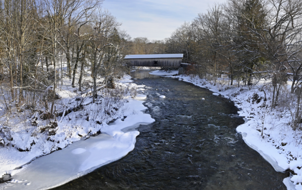
Comstock Covered Bridge Spans Salmon River in East Hampton, Connecticut
Comstock Covered Bridge Spans Salmon River in East Hampton, ConnecticutA USGS monitoring location (Salmon River Near East Hampton, CT - USGS Water Data for the Nation) on the Salmon River is situated near the historic Comstock Covered Bridge.

ADCP measurement via canoe on Connecticut River
Hydrologic technician operates Acoustic Doppler Current Profiler (ADCP) via canoe on Connecticut River.
Hydrologic technician operates Acoustic Doppler Current Profiler (ADCP) via canoe on Connecticut River.

Making a flowtracker measurement
Hydrologic technician making a flowtracker measurement during a sunny winter day at Wells River in Wells, Vermont.
Hydrologic technician making a flowtracker measurement during a sunny winter day at Wells River in Wells, Vermont.


Collecting a tap water sample
Collection of tap water samples for the USGS and New Hampshire Health and Human Services EMPoWER-U project (Evaluating Metals in Private Wells and people for Exposure Reduction – Uranium). This project evaluates uranium in private wells and couples that information with human exposure biomarkers.
Collection of tap water samples for the USGS and New Hampshire Health and Human Services EMPoWER-U project (Evaluating Metals in Private Wells and people for Exposure Reduction – Uranium). This project evaluates uranium in private wells and couples that information with human exposure biomarkers.

Collecting a pre-treatment water sample
Collection of pre-treatment water samples for the USGS and New Hampshire Health and Human Services EMPoWER-U project (Evaluating Metals in Private Wells and people for Exposure Reduction – Uranium). This project evaluates uranium in private wells and couples that information with human exposure biomarkers.
Collection of pre-treatment water samples for the USGS and New Hampshire Health and Human Services EMPoWER-U project (Evaluating Metals in Private Wells and people for Exposure Reduction – Uranium). This project evaluates uranium in private wells and couples that information with human exposure biomarkers.

Carriage road bridge over Duck Brook, Acadia National Park
Carriage road bridge over Duck Brook, Acadia National ParkCarriage road bridge over Duck Brook, Acadia National Park, near Bar Harbor, Maine.
Carriage road bridge over Duck Brook, Acadia National Park
Carriage road bridge over Duck Brook, Acadia National ParkCarriage road bridge over Duck Brook, Acadia National Park, near Bar Harbor, Maine.

Taking Acoustic Doppler Current Profiler (ADCP) measurements
Taking Acoustic Doppler Current Profiler (ADCP) measurementsHydrologic technician controls the remote data collection from the bow, while the other one paddles the canoe-ADCP rig down the Connecticut river to the next cross-section. Stratford, New Hampshire/Maistone, Vermont.

Preparing for collecting cross-section measurements
Preparing for collecting cross-section measurementsHydrologic technicians prepare for an early morning down-river Global Navigational Satellite Systems-Acoustic Doppler Current Profiler (GNSS-ADCP) survey campaign to collect cross-section measurements, Connecticut River, Maidstone, Vermont.

Preparing for Acoustic Doppler Current Profiler (ADCP) measurements
Preparing for Acoustic Doppler Current Profiler (ADCP) measurementsHydrologic technicians prepare for Acoustic Doppler Current Profiler (ADCP) measurements on Connecticut River, Maidstone, Vermont.
Preparing for Acoustic Doppler Current Profiler (ADCP) measurements
Preparing for Acoustic Doppler Current Profiler (ADCP) measurementsHydrologic technicians prepare for Acoustic Doppler Current Profiler (ADCP) measurements on Connecticut River, Maidstone, Vermont.

Performing Acoustic Doppler Current Profiler (ADCP) cross-section surveying
Performing Acoustic Doppler Current Profiler (ADCP) cross-section surveyingUSGS Hydrologic technicians perform Acoustic Doppler Current Profiler (ADCP) cross-section surveying on the Connecticut River, above Janice Peaslee Bridge, near Maidstone, Vermont.

Collecting soil samples
Hydrologist collecting soil samples for PFAS analysis, Brentwood, New Hampshire.
Hydrologist collecting soil samples for PFAS analysis, Brentwood, New Hampshire.

Fall foliage on a waterfall
Fall foliage on Bristol Falls near Bristol, Vermont. A waterfall cascades down several rock shelves.
Fall foliage on Bristol Falls near Bristol, Vermont. A waterfall cascades down several rock shelves.

Collecting a discharge measurement using a tethered River Pro
Collecting a discharge measurement using a tethered River ProUSGS employees standing on opposite banks of a river under a bridge using a River Pro. Hydrologic technicians tethered a River Pro and are pushing/pulling it across the Ware river to collect a discharge measurement.