
Continuous water quality gaging station located at Farm River at Trolley Museum at East Haven, Connecticut (USGS site ID 411626072514501).
Images
Click through our gallery of photographs showcasing New England Water Science Center research projects and monitoring work throughout the region.
Filter Total Items: 601

Continuous water quality gaging station
Continuous water quality gaging station located at Farm River at Trolley Museum at East Haven, Connecticut (USGS site ID 411626072514501).

Sam Banas performing a calibration test of a precipitation tipping bucket instrument
Sam Banas performing a calibration test of a precipitation tipping bucket instrumentSam Banas performing a calibration test of a precipitation tipping bucket instrument.
Spring 2023 Photo Contest Winner: Sam Banas, USGS at Work category

Measuring Snowpack in Sleepers River Research Watershed
Measuring Snowpack in Sleepers River Research WatershedA USGS physical scientist weighs a fiberglass tube containing a snow core on a hanging spring scale. Snow water equivalent (SWE) is calculated from the weight and volume of the snow in the tube. This measurement is being taken in Sleepers River Research Watershed in Danville, Vermont.

Streamgage on Pope Brook Tributary in Sleepers River Watershed
Streamgage on Pope Brook Tributary in Sleepers River WatershedThis streamgage is located in North Danville, Vermont, a part of the Sleepers River watershed. It is located on Pope Brook, a tributary of Sleepers River. Check out the water data for this streamgage station here.


Hydrologic Technicians recover a continuous monitor buoy in the Southport, CT estuary near the Long Island Sound
Hydrologic Technicians recover a continuous monitor buoy in the Southport, CT estuary near the Long Island SoundPhysical scientists and hydrologic technicians from New England Water Science Center and Woods Hole Dive Team recover and repair a continuous monitor buoy in the Southport, Connecticut estuary near the Long Island Sound. The buoy had been damaged in a recent storm.
Winter 2023 Photo Contest Winner: Donald Jeandervin, USGS at Work category

Hydrologic Technicians moored an acoustic doppler velocity meter (ADVM) in the channel of the Southport, CT river estuary
Hydrologic Technicians moored an acoustic doppler velocity meter (ADVM) in the channel of the Southport, CT river estuaryHydrologic Technicians Paul Solis, Brittney Izbicki and Nigel Pepin of the New England WSC CT office point to where they have just moored an acoustic doppler velocity meter (ADVM) in the channel of the Southport, CT river estuary.
Winter 2023 Photo Contest: Donald Jeandervin, Honorable Mention category
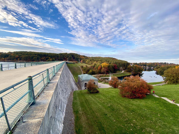
Wachusett Dam, Clinton, Massachusetts
The Wachusett Dam in Clinton, Massachusetts, completed in 1905, impounds the Nashua River to form the 65‑billion‑gallon Wachusett Reservoir, a major water‑supply source for metropolitan Boston. This granite gravity dam regulates downstream flow and maintains stable reservoir levels that support long‑term regional water‑resource management.
The Wachusett Dam in Clinton, Massachusetts, completed in 1905, impounds the Nashua River to form the 65‑billion‑gallon Wachusett Reservoir, a major water‑supply source for metropolitan Boston. This granite gravity dam regulates downstream flow and maintains stable reservoir levels that support long‑term regional water‑resource management.
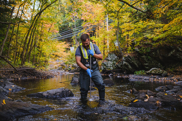
Water Sample taken from the Saugatuck River near Redding, Connecticut
Water Sample taken from the Saugatuck River near Redding, ConnecticutUSGS Hydrologic technician Ryan Bottorff takes a water sample from the Saugatuck River in Redding, Connecticut, near USGS streamgage 01208990.
Water Sample taken from the Saugatuck River near Redding, Connecticut
Water Sample taken from the Saugatuck River near Redding, ConnecticutUSGS Hydrologic technician Ryan Bottorff takes a water sample from the Saugatuck River in Redding, Connecticut, near USGS streamgage 01208990.

Mill River at Northampton, Massachusetts
U.S. Geological Survey Mill River at Northampton, Massachusetts streamgage (01171500) on October 11, 2022 looking downstream. The low-flow was about 12 cubic feet per second (cfs) for a 56.2-square-mile drainage area.
U.S. Geological Survey Mill River at Northampton, Massachusetts streamgage (01171500) on October 11, 2022 looking downstream. The low-flow was about 12 cubic feet per second (cfs) for a 56.2-square-mile drainage area.

Green River near Colrain, Massachusetts
A downstream view of the Green River near Colrain, Massachusetts close to the USGS streamgage (01170100). The low-flow was about 7.7 cubic feet per second (cfs) for a 41.4-square-mile drainage area.
A downstream view of the Green River near Colrain, Massachusetts close to the USGS streamgage (01170100). The low-flow was about 7.7 cubic feet per second (cfs) for a 41.4-square-mile drainage area.

Unnamed tributary to Trapfall Brook in Ashby, Massachusetts
Unnamed tributary to Trapfall Brook in Ashby, MassachusettsUnnamed tributary to Trapfall Brook at Harris Road in Ashby, Massachusetts, on October 1, 2021. The shallowness of water in the culvert could impede aquatic organism passage.
Unnamed tributary to Trapfall Brook in Ashby, Massachusetts
Unnamed tributary to Trapfall Brook in Ashby, MassachusettsUnnamed tributary to Trapfall Brook at Harris Road in Ashby, Massachusetts, on October 1, 2021. The shallowness of water in the culvert could impede aquatic organism passage.

Pearl Hill Brook in Ashby, Massachusetts
Pearl Hill Brook at Mill Creek Drive in Ashby, Massachusetts on October 1, 2021. The drop at the outflow of the culvert would impede aquatic organism passage.
Pearl Hill Brook at Mill Creek Drive in Ashby, Massachusetts on October 1, 2021. The drop at the outflow of the culvert would impede aquatic organism passage.
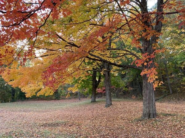
Autumn splendor at Wachusett Reservoir confluence
Vibrant autumn foliage of maple trees near the confluence of the Stillwater and Quinapoxet Rivers at the Wachusett Reservoir in West Boylston, Massachusetts.
Vibrant autumn foliage of maple trees near the confluence of the Stillwater and Quinapoxet Rivers at the Wachusett Reservoir in West Boylston, Massachusetts.

A railroad crossing over the Penobscot River in Grindstone, Maine
A railroad crossing over the Penobscot River in Grindstone, MaineA railroad crossing over the East Branch Penobscot River located at a streamgage 01029500 in Grindstone, Maine
A railroad crossing over the Penobscot River in Grindstone, Maine
A railroad crossing over the Penobscot River in Grindstone, MaineA railroad crossing over the East Branch Penobscot River located at a streamgage 01029500 in Grindstone, Maine

USGS Real-time Groundwater-Level Data at Mashpee, Massachusetts (Site 413525070291904)
USGS Real-time Groundwater-Level Data at Mashpee, Massachusetts (Site 413525070291904)USGS monitors groundwater levels at sites around the Nation. The location and frequency of water-level measurements depends on the objectives of the project or program for which the data are being collected.
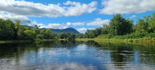
Panoramic view of the East Branch Penobscot River from the Big Seboeis Area
Panoramic view of the East Branch Penobscot River from the Big Seboeis AreaPanoramic view of the East Branch Penobscot River from the Big Seboeis area within the Katahdin Woods and Water National Monument in Maine.
Panoramic view of the East Branch Penobscot River from the Big Seboeis Area
Panoramic view of the East Branch Penobscot River from the Big Seboeis AreaPanoramic view of the East Branch Penobscot River from the Big Seboeis area within the Katahdin Woods and Water National Monument in Maine.

Non-motorized boat course
Non-motorized watercraft training practical exercises (canoe rescues) in Buffumville Lake, Oxford, MA
Summer 2022 Photo Contest: Andrew Massey, Honorable Mention category
Non-motorized watercraft training practical exercises (canoe rescues) in Buffumville Lake, Oxford, MA
Summer 2022 Photo Contest: Andrew Massey, Honorable Mention category