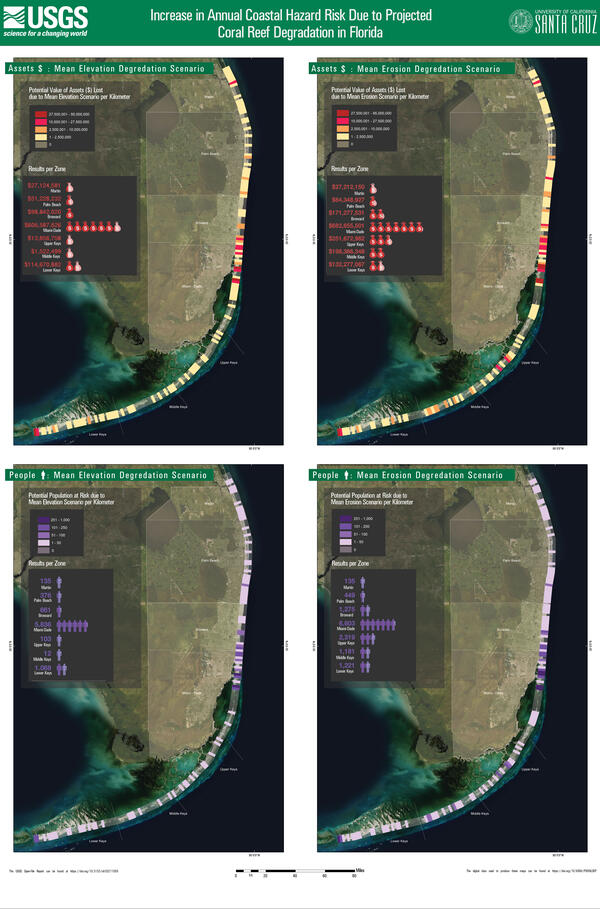
A diagram showing an overview of the study area and the passage of Hurricane María
A diagram showing an overview of the study area and the passage of Hurricane MaríaOverview of the study area and the passage of Hurricane María.
An official website of the United States government
Here's how you know
Official websites use .gov
A .gov website belongs to an official government organization in the United States.
Secure .gov websites use HTTPS
A lock () or https:// means you’ve safely connected to the .gov website. Share sensitive information only on official, secure websites.
Pacific Coastal and Marine Science Center images.
Overview of the study area and the passage of Hurricane María.
Ocean engineer Gerry Hatcher, of the USGS Pacific Coastal and Marine Science Center (PCMSC), sits at a desk on board the USGS boat Sallenger. He and a team of scientists from PCMSC and sister team St.
Looking across the back deck/stern of the R/V Robert Gordon Sproul. The wire going through the block in the A-frame leads to the CHIRP sonar fish towed in the water. Oil platforms are shown in the distance.
A three-dimensional hydrodynamic model of the lower Columbia River (LCR) was constructed using the Delft3D Flexible Mesh (DFM) modeling suite to simulate water levels, flow, and seabed stresses between January 1, 2017, and April 20, 2020
Photograph of the Lake Tahoe lakebed near Dollar Point, in March 2021.
Examples of orthomosaic imagery and high-resolution digital surface models of Puget Creek and Dickman Mill Park in Tacoma, WA.
Examples of orthomosaic imagery and a high-resolution digital surface model of Post Point, Bellingham Bay, WA.
The GeoEel is a multichannel digital streamer system, with hydrophones in a long, green hose. The streamer is towed in the water from a vessel like a long snake, and the hydrophones "listen" for and record the signals from the seismic sound source.
In August of 2020, the enormous CZU wildfire complex consumed over 85,000 acres in San Mateo and Santa Cruz Counties, leaving scarred landscapes in the hilly region. Runoff from large rainstorms in the winter months carry contaminants from the soils within these burned-out forests.
Rilling and a shallow landslide in CZU Fire near Eagle Rock, California. Soil ~3 cm below surface was almost completely dry after the rain storm, highlighting soil water repellancy.
In August of 2020, the enormous CZU wildfire complex consumed over 85,000 acres in San Mateo and Santa Cruz Counties, leaving scarred landscapes in the hilly region. Runoff from large rainstorms in the winter months carry contaminants from the soils within these burned-out forests.
The atmospheric river, a narrow, powerful track of water vapor that can deliver tremendous volumes of rain, hit the central California coast and stalled there between January 26 and 28, 2021 — with catastrophic consequences.
California's Highway 1 snakes its way along the steep terrain of the Big Sur coast. The bridge over Villa Creek can be seen in the left of the photo, as well as a retaining wall built under the freeway towards the center. These are just a few of the engineering feats by Caltrans to keep the roadway intact.
A two-day rainstorm from January 26-28, 2021 caused numerous mudslides, debris flows, and other issues along California's coastal Highway 1 through Big Sur. This section is just north of Kirk Creek, at a drainage where mud was washed across the roadway. Plumes of the muddy runoff are clearly visible in the ocean.
A two-day rainstorm from January 26-28, 2021 caused numerous mudslides, debris flows, and other issues along California's coastal Highway 1 through Big Sur. This is Big Creek Bridge, and Big Creek is still murky. Plumes of the muddy runoff are clearly visible in the ocean.
The atmospheric river, a narrow, powerful track of water vapor that can deliver tremendous volumes of rain, hit the central California coast and stalled there between January 26 and 28, 2021 — with catastrophic consequences.
A two-day rainstorm from January 26-28, 2021 caused numerous mudslides, debris flows, and other issues along California's coastal Highway 1 through Big Sur. This section is just north of Wild Cattle Creek. Mud washed across the roadway from the cliffs in numerous locations along the 70+-mile stretch of this scenic coastal road.
A section of Highway 1 along the California coast in Big Sur with more examples of the numerous debris flows and mudslides that occur following a heavy rain. This section is just south of the Rat Creek debris flow that completely washed out a large chunk of the highway.
The atmospheric river, a narrow, powerful track of water vapor that can deliver tremendous volumes of rain, hit the central California coast and stalled there between January 26 and 28, 2021 — with catastrophic consequences.