
Underwater Landslides off Southern California
An earthquake can trigger a landslide along the ocean floor, which can then set off a tsunami. Without modern, high-resolution imaging of the seafloor, many historical slides and threats from future slides remain undetected.
Central & Northern CA

USGS images offshore faults in central and northern California that could trigger devastating earthquakes near densely populated areas and a nuclear power plant.
Southeastern AK

USGS uses sophisticated techniques to truly understand the Queen Charlotte-Fairweather (QCF) fault system’s hazard potential in southeastern Alaska.
SoCal Seafloor Faults

USGS aims to boost our knowledge about faults on the seafloor offshore of southern California (SoCal), so they can be included in hazard assessments.

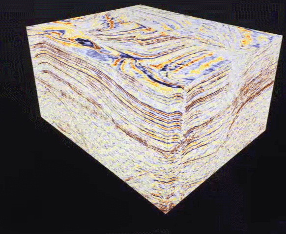
Using equipment that stretched several kilometers behind their vessels, the petroleum industry ran 3D seismic surveys off Santa Barbara in the 1990s. When they released their data to the public in 2015, USGS geophysicist Jared Kluesner could finally sift through the values to create a 3D view of the Earth extending thousands of meters beneath the seafloor. This view was a vast improvement over the paper-thin slices of Earth’s crust that are constructed from 2D surveys. Tens of gigabytes of data required months of number crunching and the largest monitor that could fit on Kluesner’s desk. His “geologic Hubble telescope” allowed him to virtually explore kilometers below the seafloor in any direction, map faults, and study how fluid moves through the Earth’s crust.
Issue

Underwater landslides threaten offshore structures such as seafloor pipelines, cables, and equipment for oil and gas exploration. These landslides can also trigger tsunamis that endanger coastal communities. A 1998 earthquake in Papua New Guinea triggered a landslide on the seafloor, which generated a 10-meter high tsunami that killed more than 2,000 people along the nearest shoreline.
Until recently, scientists had not looked closely for similar landslides off the Southern California coast. Previously known slides in the region are the Goleta slide in Santa Barbara Channel and the Palos Verdes debris avalanche off Palos Verdes Peninsula, each less than half a cubic kilometer in size. Underwater landslides might have triggered significant tsunamis in Santa Barbara in 1812 and Point Arguello in 1927. But inadequate seafloor mapping in the area limits what scientists know about the size, distribution, and age of potential tsunami-generated landslides. Numerous banks and ridges beneath the waters off the Southern California coast could hide undiscovered slides.
As an example, a 2010 NOAA cruise to map the seafloor around the Santa Cruz Basin 50 to 80 kilometers from Ventura, accidentally discovered several underwater landslide scars. The scars show considerable variation in appearance, suggesting a wide range of ages for individual slides. The landslides range in size from less than 1 to more than 50 square kilometers, making this one of the largest underwater landslide complexes found off Southern California.
What the USGS is doing
To understand the potential tsunami hazards that underwater landslides pose to Southern California, the USGS led a high-resolution 2D seismic study in Santa Cruz Basin and nearby basins in November 2014. This work should help identify what makes slopes unstable, what may trigger them to slide (active faults, sediment buildup, fluid channels beneath the seabed), and what potential exists for slides to generate local tsunamis.
To dig further into the complexities of these landslides, USGS researchers used advanced techniques to analyze 3D seismic data collected by the oil industry. These data from near the Goleta slide in Santa Barbara Basin help USGS scientists make connections between underwater landslides and natural events that make a slope fail. Researchers compare lower resolution 3D seismic images with higher resolution 2D data to link the 3D data to the landslides seen on the seafloor.
USGS scientists continue to collect more seafloor mapping data looking for changes to the seafloor and seafloor seeps, which can indicate mounting fluid pressure that could trigger landslides.


What the USGS has learned
Recent research within Santa Cruz Basin shows landslides ranging from 6,000 to 8,000 years old.
New seafloor data revealed the Del Mar slide, just north of San Diego. The steep slope here has landslides more than 6 kilometers wide, about 8 kilometers west of Del Mar, along the edge of the continental shelf. Seismic data show the slide deposit is up to 20 meters thick and extends nearly 10 kilometers to the west. Data also reveal older slide deposits buried beneath the seafloor. A sediment core taken near the toe of the slide indicates it may be about 14,000 to16,000 years old, and that slides could recur here on a timescale of tens of thousands of years.
It’s likely that more offshore landslides are yet to be discovered.


Below are the current studies of the “U.S. West Coast and Alaska Marine Geohazards” Project.

Coastal and Marine Geohazards of the U.S. West Coast and Alaska

Seafloor Faults off Southern California

Offshore Faults along Central and Northern California

Underwater Landslides off Southern California

Earthquake Hazards in Southeastern Alaska
An earthquake can trigger a landslide along the ocean floor, which can then set off a tsunami. Without modern, high-resolution imaging of the seafloor, many historical slides and threats from future slides remain undetected.
Central & Northern CA
USGS images offshore faults in central and northern California that could trigger devastating earthquakes near densely populated areas and a nuclear power plant.
Southeastern AK
USGS uses sophisticated techniques to truly understand the Queen Charlotte-Fairweather (QCF) fault system’s hazard potential in southeastern Alaska.
SoCal Seafloor Faults
USGS aims to boost our knowledge about faults on the seafloor offshore of southern California (SoCal), so they can be included in hazard assessments.
Using equipment that stretched several kilometers behind their vessels, the petroleum industry ran 3D seismic surveys off Santa Barbara in the 1990s. When they released their data to the public in 2015, USGS geophysicist Jared Kluesner could finally sift through the values to create a 3D view of the Earth extending thousands of meters beneath the seafloor. This view was a vast improvement over the paper-thin slices of Earth’s crust that are constructed from 2D surveys. Tens of gigabytes of data required months of number crunching and the largest monitor that could fit on Kluesner’s desk. His “geologic Hubble telescope” allowed him to virtually explore kilometers below the seafloor in any direction, map faults, and study how fluid moves through the Earth’s crust.
Issue
Underwater landslides threaten offshore structures such as seafloor pipelines, cables, and equipment for oil and gas exploration. These landslides can also trigger tsunamis that endanger coastal communities. A 1998 earthquake in Papua New Guinea triggered a landslide on the seafloor, which generated a 10-meter high tsunami that killed more than 2,000 people along the nearest shoreline.
Until recently, scientists had not looked closely for similar landslides off the Southern California coast. Previously known slides in the region are the Goleta slide in Santa Barbara Channel and the Palos Verdes debris avalanche off Palos Verdes Peninsula, each less than half a cubic kilometer in size. Underwater landslides might have triggered significant tsunamis in Santa Barbara in 1812 and Point Arguello in 1927. But inadequate seafloor mapping in the area limits what scientists know about the size, distribution, and age of potential tsunami-generated landslides. Numerous banks and ridges beneath the waters off the Southern California coast could hide undiscovered slides.
As an example, a 2010 NOAA cruise to map the seafloor around the Santa Cruz Basin 50 to 80 kilometers from Ventura, accidentally discovered several underwater landslide scars. The scars show considerable variation in appearance, suggesting a wide range of ages for individual slides. The landslides range in size from less than 1 to more than 50 square kilometers, making this one of the largest underwater landslide complexes found off Southern California.
What the USGS is doing
To understand the potential tsunami hazards that underwater landslides pose to Southern California, the USGS led a high-resolution 2D seismic study in Santa Cruz Basin and nearby basins in November 2014. This work should help identify what makes slopes unstable, what may trigger them to slide (active faults, sediment buildup, fluid channels beneath the seabed), and what potential exists for slides to generate local tsunamis.
To dig further into the complexities of these landslides, USGS researchers used advanced techniques to analyze 3D seismic data collected by the oil industry. These data from near the Goleta slide in Santa Barbara Basin help USGS scientists make connections between underwater landslides and natural events that make a slope fail. Researchers compare lower resolution 3D seismic images with higher resolution 2D data to link the 3D data to the landslides seen on the seafloor.
USGS scientists continue to collect more seafloor mapping data looking for changes to the seafloor and seafloor seeps, which can indicate mounting fluid pressure that could trigger landslides.
What the USGS has learned
Recent research within Santa Cruz Basin shows landslides ranging from 6,000 to 8,000 years old.
New seafloor data revealed the Del Mar slide, just north of San Diego. The steep slope here has landslides more than 6 kilometers wide, about 8 kilometers west of Del Mar, along the edge of the continental shelf. Seismic data show the slide deposit is up to 20 meters thick and extends nearly 10 kilometers to the west. Data also reveal older slide deposits buried beneath the seafloor. A sediment core taken near the toe of the slide indicates it may be about 14,000 to16,000 years old, and that slides could recur here on a timescale of tens of thousands of years.
It’s likely that more offshore landslides are yet to be discovered.
Below are the current studies of the “U.S. West Coast and Alaska Marine Geohazards” Project.
Coastal and Marine Geohazards of the U.S. West Coast and Alaska
Seafloor Faults off Southern California
Offshore Faults along Central and Northern California
Underwater Landslides off Southern California