


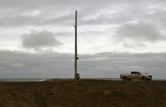
Point Barrow, Alaska, or Nuvuk, is the northernmost point in the United States. USGS has set up video cameras, mounted to the pole shown here, to study sediment movement and wave dynamics along this dynamic coastline.
Using Video Imagery to Study Sediment Transport and Wave Dynamics: Nuvuk (Point Barrow)
Active
By Pacific Coastal and Marine Science Center
September 30, 2021
Two coastal observing video cameras were installed atop a utility pole near the northernmost point of land in the United States, at Nuvuk (Point Barrow), Alaska. The cameras pointed northwest toward the Arctic Ocean and the boundary between the Chukchi and Beaufort Seas, and were used to observe and quantify coastal processes such as wave run-up, bluff erosion, movement of sandbars and ice floes, and sediment entrainment and transport by ice.
These cameras were decommissioned in September 2025 because of rapid erosion at the tower location. No new images or wave data will be collected at this location. The images below are the final photos captured prior to decommissioning.
Media

Sources/Usage: Public Domain. View Media Details
Nuvuk, Alaska sits at the end of a low-lying barrier spit about 16 km (10 miles) northeast of the Alaska Community of Utqiaġvik (formerly Barrow). This region is vulnerable to coastal erosion and marine flooding during large storm events which are now increasingly impacting the coast during the fall and early winter months. Warming trends in the Arctic are leading to reduced ice coverage and later fall and early winter freeze-up of shorefast ice allowing storm surge and ocean waves to flood and erode the otherwise protected coast.
Every half hour during daylight hours, the cameras collected snapshots and video for 10 minutes. Examples of the types of images collected are shown below.
This was the second USGS coastal observing camera installed in Alaska. The station at Unalakleet Alaska, on the coast of Norton Sound, has been operating since August 2018 (with an extended gap between November 2019 through September 2021). The knowledge gained will improve computer-derived simulations of shoreline change that communities can use to plan for sea-level rise, changing storm patterns, and other threats to coasts.
For water level and meteorological observations near the Nuvuk station, visit the Prudhoe Bay NOAA Tides & Currents site.
Media
Sources/Usage: Public Domain. View Media Details
Currently, USGS video cameras are active at these locations:
- Dream Inn hotel in Santa Cruz, California
- Head of the Meadow Beach, Massachusetts
- Marconi Beach, Massachusetts
- Norton Sound, Unalakleet, Alaska
- Sunset State Beach, California
Snapshot
The snapshot is the first frame of the video, just like a standard photo.
Timex (time-exposure) images
A timex is a time-averaged image of all frames, smoothing away surface waves and determining the location of persistent wave-breaking (indicative of shallow sandbars).
Variance images
A “variance” image shows the standard deviation of pixel intensity throughout the video, and it is useful for determining how much variation or movement is occurring at a given location.
Bright images
A “bright” image shows the brightest pixel values throughout the video, useful for identifying the position of maximum wave run-up on the beach, position of all breaking waves, and sea-state.
Dark images
A “dark” image shows the darkest pixel values throughout the video, useful for tracking sediment plumes, tracking floating debris, and filtering out breaking waves.
Media

Sources/Usage: Public Domain. View Media Details
Below are other science projects associated with this project.

Remote Sensing Coastal Change
We use remote-sensing technologies—such as aerial photography, satellite imagery, structure-from-motion (SfM) photogrammetry, and lidar (laser-based surveying)—to measure coastal change along U.S. shorelines.

Climate impacts to Arctic coasts
The Arctic region is warming faster than anywhere else in the nation. Understanding the rates and causes of coastal change in Alaska is needed to identify and mitigate hazards that might affect people and animals that call Alaska home.

Using Video Imagery to Study Coastal Change: Santa Cruz Beaches
Two video cameras atop the Dream Inn hotel in Santa Cruz, California, overlook the coast in northern Monterey Bay. One camera looks eastward over Santa Cruz Main Beach and boardwalk, while the other looks southward over Cowells Beach.

Using Video Imagery to Study Coastal Change: Sunset State Beach
Two video cameras overlook the coast at Sunset State Beach in Watsonville, California. Camera 1 looks northwest while Camera 2 looks north. The cameras are part of the Remote Sensing Coastal Change project.

Using Video Imagery to Study Wave Dynamics: Unalakleet
USGS scientists installed two video cameras atop a windmill tower in Unalakleet, Alaska, pointing westward over Norton Sound, to observe and quantify coastal processes such as wave run-up, development of rip channels, bluff erosion, and movement of sandbars and ice floes.

Using Video Imagery to Study Marconi Beach
Two video cameras are mounted on a bluff above Marconi Beach, Cape Cod National Seashore, Wellfleet, MA. One camera looks alongshore toward the northeast, and the second looks directly offshore (east). The cameras are part of a U.S. Geological Survey research project to study the beach and nearshore environment shared by beachgoers, shorebirds, seals, and sharks. The work is being conducted under...
Below are multimedia items associated with this project.

Video camera setup at Nuvuk, Alaska
Point Barrow, Alaska, or Nuvuk, is the northernmost point in the United States. USGS has set up video cameras, mounted to the pole shown here, to study sediment movement and wave dynamics along this dynamic coastline.

Video camera setup at Point Barrow, Alaska
Point Barrow, Alaska, or Nuvuk, is the northernmost point in the United States. USGS has set up video cameras, mounted to the pole shown here, to study sediment movement and wave dynamics along this dynamic coastline.
Point Barrow, Alaska, or Nuvuk, is the northernmost point in the United States. USGS has set up video cameras, mounted to the pole shown here, to study sediment movement and wave dynamics along this dynamic coastline.
Two coastal observing video cameras were installed atop a utility pole near the northernmost point of land in the United States, at Nuvuk (Point Barrow), Alaska. The cameras pointed northwest toward the Arctic Ocean and the boundary between the Chukchi and Beaufort Seas, and were used to observe and quantify coastal processes such as wave run-up, bluff erosion, movement of sandbars and ice floes, and sediment entrainment and transport by ice.
These cameras were decommissioned in September 2025 because of rapid erosion at the tower location. No new images or wave data will be collected at this location. The images below are the final photos captured prior to decommissioning.
Media
Sources/Usage: Public Domain. View Media Details
Nuvuk, Alaska sits at the end of a low-lying barrier spit about 16 km (10 miles) northeast of the Alaska Community of Utqiaġvik (formerly Barrow). This region is vulnerable to coastal erosion and marine flooding during large storm events which are now increasingly impacting the coast during the fall and early winter months. Warming trends in the Arctic are leading to reduced ice coverage and later fall and early winter freeze-up of shorefast ice allowing storm surge and ocean waves to flood and erode the otherwise protected coast.
Every half hour during daylight hours, the cameras collected snapshots and video for 10 minutes. Examples of the types of images collected are shown below.
This was the second USGS coastal observing camera installed in Alaska. The station at Unalakleet Alaska, on the coast of Norton Sound, has been operating since August 2018 (with an extended gap between November 2019 through September 2021). The knowledge gained will improve computer-derived simulations of shoreline change that communities can use to plan for sea-level rise, changing storm patterns, and other threats to coasts.
For water level and meteorological observations near the Nuvuk station, visit the Prudhoe Bay NOAA Tides & Currents site.
Media
Sources/Usage: Public Domain. View Media Details
Currently, USGS video cameras are active at these locations:
- Dream Inn hotel in Santa Cruz, California
- Head of the Meadow Beach, Massachusetts
- Marconi Beach, Massachusetts
- Norton Sound, Unalakleet, Alaska
- Sunset State Beach, California
Snapshot
The snapshot is the first frame of the video, just like a standard photo.
Timex (time-exposure) images
A timex is a time-averaged image of all frames, smoothing away surface waves and determining the location of persistent wave-breaking (indicative of shallow sandbars).
Variance images
A “variance” image shows the standard deviation of pixel intensity throughout the video, and it is useful for determining how much variation or movement is occurring at a given location.
Bright images
A “bright” image shows the brightest pixel values throughout the video, useful for identifying the position of maximum wave run-up on the beach, position of all breaking waves, and sea-state.
Dark images
A “dark” image shows the darkest pixel values throughout the video, useful for tracking sediment plumes, tracking floating debris, and filtering out breaking waves.
Media
Sources/Usage: Public Domain. View Media Details
Below are other science projects associated with this project.
Remote Sensing Coastal Change
We use remote-sensing technologies—such as aerial photography, satellite imagery, structure-from-motion (SfM) photogrammetry, and lidar (laser-based surveying)—to measure coastal change along U.S. shorelines.
Climate impacts to Arctic coasts
The Arctic region is warming faster than anywhere else in the nation. Understanding the rates and causes of coastal change in Alaska is needed to identify and mitigate hazards that might affect people and animals that call Alaska home.
Using Video Imagery to Study Coastal Change: Santa Cruz Beaches
Two video cameras atop the Dream Inn hotel in Santa Cruz, California, overlook the coast in northern Monterey Bay. One camera looks eastward over Santa Cruz Main Beach and boardwalk, while the other looks southward over Cowells Beach.
Using Video Imagery to Study Coastal Change: Sunset State Beach
Two video cameras overlook the coast at Sunset State Beach in Watsonville, California. Camera 1 looks northwest while Camera 2 looks north. The cameras are part of the Remote Sensing Coastal Change project.
Using Video Imagery to Study Wave Dynamics: Unalakleet
USGS scientists installed two video cameras atop a windmill tower in Unalakleet, Alaska, pointing westward over Norton Sound, to observe and quantify coastal processes such as wave run-up, development of rip channels, bluff erosion, and movement of sandbars and ice floes.
Using Video Imagery to Study Marconi Beach
Two video cameras are mounted on a bluff above Marconi Beach, Cape Cod National Seashore, Wellfleet, MA. One camera looks alongshore toward the northeast, and the second looks directly offshore (east). The cameras are part of a U.S. Geological Survey research project to study the beach and nearshore environment shared by beachgoers, shorebirds, seals, and sharks. The work is being conducted under...
Below are multimedia items associated with this project.
Video camera setup at Nuvuk, Alaska
Point Barrow, Alaska, or Nuvuk, is the northernmost point in the United States. USGS has set up video cameras, mounted to the pole shown here, to study sediment movement and wave dynamics along this dynamic coastline.
Point Barrow, Alaska, or Nuvuk, is the northernmost point in the United States. USGS has set up video cameras, mounted to the pole shown here, to study sediment movement and wave dynamics along this dynamic coastline.
Video camera setup at Point Barrow, Alaska
Point Barrow, Alaska, or Nuvuk, is the northernmost point in the United States. USGS has set up video cameras, mounted to the pole shown here, to study sediment movement and wave dynamics along this dynamic coastline.
Point Barrow, Alaska, or Nuvuk, is the northernmost point in the United States. USGS has set up video cameras, mounted to the pole shown here, to study sediment movement and wave dynamics along this dynamic coastline.