
Hydrology and Geomorphology
Hydrology and Geomorphology
Select a topic below, and relevant webpages will show up below the list of topics.
Filter Total Items: 33
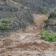
A New App to Report Flash Floods and Debris Flows in Grand Canyon
A new community science tool helps scientists gather valuable information on hazardous events such as floods, debris flows, and landslides that occur in the backcountry of Grand Canyon National Park. Visitors to Grand Canyon can help improve our understanding of the impacts these events have which helps to improve future warnings.

Lake Powell Research
Lake Powell is a large arid reservoir that represents about 70% of the water storage capacity for the Upper Colorado River Basin. It is the second largest reservoir in the United States by capacity (second only to Lake Mead). Lake Powell is an oligotrophic reservoir, which means that nutrient concentrations and algal production are generally low. This often results in very clear-water conditions...

SBSC: Providing Unbiased Actionable Science & Information to Support Natural Resource Management Needs of the U.S. & Department of the Interior Priorities
The U.S. Geological Survey Southwest Biological Science Center (SBSC) is uniquely positioned in the Colorado River Basin to provide sound information, specialized expertise, and innovative tools to support the management and sustained use of natural resources on public and Tribal lands in the Southwest U.S.
Vegetation monitoring: How one square meter can tell the story of 255 river miles along the Colorado River
The goal of SBSC's Grand Canyon Monitoring and Research Center’s (GCMRC) riparian vegetation monitoring program is to assess changes and trends in plant species composition and cover and relate those changes to river hydrology, climate, geomorphology, and the operations of Glen Canyon Dam.
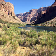
Riparian Vegetation in Grand Canyon: An Overview
Riparian plant communities, associated with rivers and streams, are ecologically and culturally important areas in the southwestern U.S. Despite covering less than 2% of the land area in the southwest, the resources provided by these communities make them valuable to wildlife, the public, scientists, and resource managers.

River Sediment Dynamics
Sediment controls the physical habitat of river ecosystems. Changes in the amount and areal distribution of different sediment types cause changes in river-channel form and river habitat. The amount and type of sediment suspended in the water column determines water clarity. Understanding sediment transport and the conditions under which sediment is deposited or eroded from the various...

Colorado River Basin Science
The Grand Canyon Monitoring and Research Center, a branch of the Southwest Biological Science Center, conducts scientific assessments of the Colorado River in Grand Canyon, focused primarily on Lake Powell and the river ecosystem downstream of Glen Canyon Dam. On this page, we'd like to share related interactive tools and projects by other USGS Centers that cover science across the upper and lower...

RAMPS: Restoration Assessment & Monitoring Program for the Southwest
The Restoration Assessment and Monitoring Program for the Southwest (RAMPS) seeks to assist U.S. Department of the Interior (DOI) and other land management agencies in developing successful techniques for improving land condition in dryland ecosystems of the southwestern United States. Invasion by non-native species, wildfire, drought, and other disturbances are growing rapidly in extent and...

Smallmouth bass expansion downstream of Glen Canyon Dam
In the Upper Colorado River Basin, smallmouth bass ( Micropterus dolomieu) are considered the greatest threat to native fishes and have been linked to declines in federally protected humpback chub ( Gila cypha), including one population that was rapidly extirpated in the past. Long-term management efforts have been underway to remove smallmouth bass from rivers in the Upper Basin, but smallmouth...

Rio Grande/Rio Bravo Research
The Rio Grande/Rio Bravo (hereafter referred to as the Rio Grande) in the Big Bend region of Texas, USA, and Chihuahua and Coahuila, Mexico, has substantially narrowed since the early 1900s. This narrowing has been caused by the construction and operation of dams and irrigation diversions in upstream reaches of the Rio Grande in the U.S. and the Rio Conchos in Mexico that has reduced flows without...

River Geomorphology, Sediment Storage, Sandbar and Campsite Monitoring in Grand Canyon
River channels and their adjacent floodplains are ever evolving in form and composition in response to changing patterns of streamflow, the quantity and size of supplied sediment, and feedbacks with the riparian and aquatic ecosystems. Changes in channel form affect aquatic and riparian habitats, which are important for plants, animals, and insects. Erosion and deposition of river channels and...

SBSC Tribal Partnerships
The Southwest Biological Science Center (SBSC) conducts and provides scientific information as part of our mission and Federal Trust Responsibility to strengthen relationships and build partnerships with sovereign tribal nations. Here, we highlight a few examples of projects with tribal partners.