
Remote Sensing and GIS
Remote Sensing and GIS
Filter Total Items: 25

New Tools for Modern Land Management Decisions
In an era of rapid land use changes, it is imperative that land managers and policymakers have actionable and current information available for decision processes. In this work, we seek to meet these needs through new data products and decision support tools built on digital soil mapping, new vegetation cover maps, agency inventory and monitoring data sets, and cutting-edge analytical frameworks...
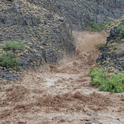
A New App to Report Flash Floods and Debris Flows in Grand Canyon
A new community science tool helps scientists gather valuable information on hazardous events such as floods, debris flows, and landslides that occur in the backcountry of Grand Canyon National Park. Visitors to Grand Canyon can help improve our understanding of the impacts these events have which helps to improve future warnings.

SBSC: Providing Unbiased Actionable Science & Information to Support Natural Resource Management Needs of the U.S. & Department of the Interior Priorities
The U.S. Geological Survey Southwest Biological Science Center (SBSC) is uniquely positioned in the Colorado River Basin to provide sound information, specialized expertise, and innovative tools to support the management and sustained use of natural resources on public and Tribal lands in the Southwest U.S.

The Innovation Landscape Network
As public, tribal, and military lands continue to experience rapid change brought on by fire, invasive species, and drought, there is a growing need for science-management partnerships to apply innovative research and technologies to support decision-making at an accelerated pace.

WebDART: A Cutting-edge Web Tool that Evaluates Land Condition
WebDART is an online ecological assessment tool available to a wide audience that incorporates Landsat satellite remote sensing imagery, topography, geology, soil conditions, and rangeland geospatial and vegetation mapping to compare altered terrain with an unspoiled area that has similar characteristics in the same region. The tool gives resource managers, landowners, companies, and other...
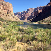
Vegetation monitoring: How one square meter can tell the story of 255 river miles along the Colorado River
The goal of SBSC's Grand Canyon Monitoring and Research Center’s (GCMRC) riparian vegetation monitoring program is to assess changes and trends in plant species composition and cover and relate those changes to river hydrology, climate, geomorphology, and the operations of Glen Canyon Dam.

Southwest Fire Innovation Landscape Network: Advanced tools for fuel monitoring and assessment of wildfire risk
The USGS Southwest Biological Science Center is coordinating the Southwest Fire Innovation Landscape Network to prepare fire and natural resource managers for rapidly changing fire landscapes by conducting research and building science-management partnerships. The network develops advanced tools and technologies to assess fuel loads and the effectiveness of fuel treatments, understand wildfire...
Riparian Vegetation in Grand Canyon: An Overview
Riparian plant communities, associated with rivers and streams, are ecologically and culturally important areas in the southwestern U.S. Despite covering less than 2% of the land area in the southwest, the resources provided by these communities make them valuable to wildlife, the public, scientists, and resource managers.

SBSC science supports invasive species management
Invasive species can harm ecosystems, increase wildfires, damage forests, and outcompete native species. The US Geological Survey's Southwest Biological Science Center conducts research that provides our federal and state partners, cooperators and land managers with the tools, data and strategies to enhance biosecurity management. Scroll through the information below to read about different SBSC...

River Sediment Dynamics
Sediment controls the physical habitat of river ecosystems. Changes in the amount and areal distribution of different sediment types cause changes in river-channel form and river habitat. The amount and type of sediment suspended in the water column determines water clarity. Understanding sediment transport and the conditions under which sediment is deposited or eroded from the various...

Colorado River Basin Science
The Grand Canyon Monitoring and Research Center, a branch of the Southwest Biological Science Center, conducts scientific assessments of the Colorado River in Grand Canyon, focused primarily on Lake Powell and the river ecosystem downstream of Glen Canyon Dam. On this page, we'd like to share related interactive tools and projects by other USGS Centers that cover science across the upper and lower...

River Geomorphology, Sediment Storage, Sandbar and Campsite Monitoring in Grand Canyon
River channels and their adjacent floodplains are ever evolving in form and composition in response to changing patterns of streamflow, the quantity and size of supplied sediment, and feedbacks with the riparian and aquatic ecosystems. Changes in channel form affect aquatic and riparian habitats, which are important for plants, animals, and insects. Erosion and deposition of river channels and...