



The USGS Coastal Change Hazards team collects data to monitor coastal change – including how storms and waves shape and reshape our beaches. It’s important to keep track of how beaches change over time because they provide habitat for many creatures including birds and sea turtles, and they are beautiful locations where people love to live and vacation.
Images
St. Petersburg Coastal and Marine Science Center images.
Filter Total Items: 760

Sea Turtle Nest on Madeira Beach
The USGS Coastal Change Hazards team collects data to monitor coastal change – including how storms and waves shape and reshape our beaches. It’s important to keep track of how beaches change over time because they provide habitat for many creatures including birds and sea turtles, and they are beautiful locations where people love to live and vacation.

Beach Profile Survey
Justin Birchler, Physical Scientist with the USGS Coastal Change Hazards team conducts a beach profile survey at our field site on Madeira Beach. During these surveys, Justin wears a backpack with GPS equipment to collect elevation data that will be used to create a topographic map of the beach.
Justin Birchler, Physical Scientist with the USGS Coastal Change Hazards team conducts a beach profile survey at our field site on Madeira Beach. During these surveys, Justin wears a backpack with GPS equipment to collect elevation data that will be used to create a topographic map of the beach.

Madeira Beach Camera Time Series
This photo is the results of processing a time series of images, which are a combination of all image frames collected during a 10 to 17-minute video. These images are incredibly useful for studying coastal change remotely, but the usefulness of the image depends on how they are processed.
This photo is the results of processing a time series of images, which are a combination of all image frames collected during a 10 to 17-minute video. These images are incredibly useful for studying coastal change remotely, but the usefulness of the image depends on how they are processed.

Aerial photos of barrier islands
We conduct fieldwork in a variety of barrier island settings to understand the relative importance of these factors, including Fire Island, NY; Rockaway, NY; Seven Mile Island, NJ; and Cedar Island, VA.
We conduct fieldwork in a variety of barrier island settings to understand the relative importance of these factors, including Fire Island, NY; Rockaway, NY; Seven Mile Island, NJ; and Cedar Island, VA.

USGS Scientists Work on Four Tropical Cyclones at Once
USGS Scientists Work on Four Tropical Cyclones at OnceIn this NOAA satellite image from Sept. 15, 2020, Hurricane Sally approaches the U.S. Gulf Coast, Hurricane Paulettte creates storm waves far out in the Atlantic, and Tropical Storms Teddy and Vicky lie near the coast of Africa. Two tropical depressions are also developing; one of them is not visible in this image.

Coastal Change Hazards Portal shows Hurricane Sally near Gulf Coast
Coastal Change Hazards Portal shows Hurricane Sally near Gulf CoastAs Hurricane Sally approached the US Gulf Coast, the USGS Coastal Change Hazards team produced a series of forecasts for impacts on the beach. Forecasts were updated daily based on wave and storm surge forecasts from NOAA.

Total Water Level and Coastal Change Forecast Expansion, 2020
Total Water Level and Coastal Change Forecast Expansion, 2020The Total Water Level and Coastal Change Forecast has continually expanded since real-time forecasts began in 2015. In 2020, new regions of the Gulf and South Atlantic coasts were added to the forecast and officially approved for use in National Weather Service Forecasts.

Aerial image from post-Hurricane Isaias of North Carolina coast
Aerial image from post-Hurricane Isaias of North Carolina coastThe USGS Remote Sensing Coastal Change Project collected aerial imagery of the northern Outer Banks, North Carolina coastline from pre- and post-Hurricane Isaias, in order to use Structure-from-Motion techniques to produce digital elevation models (DEMs) and orthomosaic photos, to be used in evaluating the storm-induced coastal change, such as sand transported onto
Hurricane Isaias Unlikely to Cause Widespread Atlantic Beach Erosion
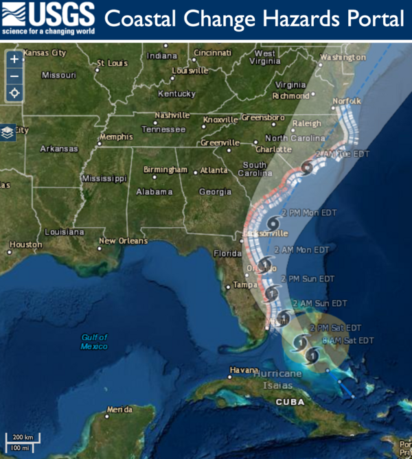
Hurricane Isaias Unlikely to Cause Widespread Atlantic Beach ErosionUSGS coastal change experts predict that storm waves kicked up by the Category 1 hurricane are likely to cause some erosion at the base of the dunes along about 11 percent of coastal beaches between Florida and Virginia.

Seamline Appearance Before and After Applying a DEM Fusion Algorithm
Seamline Appearance Before and After Applying a DEM Fusion AlgorithmA map series showing a subset of the Puerto Rico bathymetric study area. Panels compare a “simple mosaic” formed by overlaying the most recent dataset on top of the older dataset (left panel) with the same dataset processed with the DEM fusion method (right panel).

Vegetated dunes on Cocoa Beach, Florida
A view looking north on Cocoa beach towards Kennedy Space Station. Coastal infrastructure and natural resources such as sediment and beach vegetation can all be affected by coastal change processes.
A view looking north on Cocoa beach towards Kennedy Space Station. Coastal infrastructure and natural resources such as sediment and beach vegetation can all be affected by coastal change processes.

A large washover fan on Fire Island, New York in 2012 after Hurricane
A large washover fan on Fire Island, New York in 2012 after HurricaneStrong storms such as hurricanes can cause drastic changes to coastal environments. For example, this large washover fan was created on Fire Island, New York in 2012 after Hurricane Sandy by waves moving sediment from the dunes and beach towards the back-barrier environment.

Lake Sediment Core
Section of a sediment core collected from the deepest basin of Lake Enriquillo in the Dominican Republic. USGS scientists are analyzing cores from the lake to reconstruct past changes in rainfall.
Section of a sediment core collected from the deepest basin of Lake Enriquillo in the Dominican Republic. USGS scientists are analyzing cores from the lake to reconstruct past changes in rainfall.

Cedar Island, Virginia 1994 - 2014
Cedar Island, Virginia is an uninhabited barrier that has migrated landward approximately 15-30 meters per year since 1984 due to its low sediment supply. The shoreface slope is gradual but almost entirely devoid of island sediment - both responses to its recent, rapid retreat. USGS scientists collect geologic and morphologic data from this island’s shoreface.
Cedar Island, Virginia is an uninhabited barrier that has migrated landward approximately 15-30 meters per year since 1984 due to its low sediment supply. The shoreface slope is gradual but almost entirely devoid of island sediment - both responses to its recent, rapid retreat. USGS scientists collect geologic and morphologic data from this island’s shoreface.

Fire Island, New York 1994 - 2014
Fire Island, New York is sparsely populated and regularly nourished, but has few modifications that impede natural sediment exchanges. Shoreface geomorphology reflects past periods of seaward progradation and alongshore extension resulting in a relatively sediment-rich shoreface. USGS scientists collect geologic and morphologic data from this island’s shoreface.
Fire Island, New York is sparsely populated and regularly nourished, but has few modifications that impede natural sediment exchanges. Shoreface geomorphology reflects past periods of seaward progradation and alongshore extension resulting in a relatively sediment-rich shoreface. USGS scientists collect geologic and morphologic data from this island’s shoreface.

Rockaway Beach, New York 1994 - 2014
Rockaway Beach, New York is heavily developed, has seawalls and groins and is regularly nourished. It hasn’t changed much over 20 years. The shoreface is steep and sediment cover doesn’t extend far from shore—likely the result of being fixed in place for decades. USGS scientists collect geologic and morphologic data from this island’s shoreface.
Rockaway Beach, New York is heavily developed, has seawalls and groins and is regularly nourished. It hasn’t changed much over 20 years. The shoreface is steep and sediment cover doesn’t extend far from shore—likely the result of being fixed in place for decades. USGS scientists collect geologic and morphologic data from this island’s shoreface.

Modeled beach profile evolution at Parramore Island, Virginia
Modeled beach profile evolution at Parramore Island, VirginiaAnimation displays modeled beach profile elevation as it has evolved at Parramore Island, Virginia. These data are based on geomorphic investigation and measure distance (in kilometers) of cross-shore accretion. QS is the flux of sand to the beach, and QD is the flux of sand from the beach to the active dune.
Modeled beach profile evolution at Fishing Point, Virginia
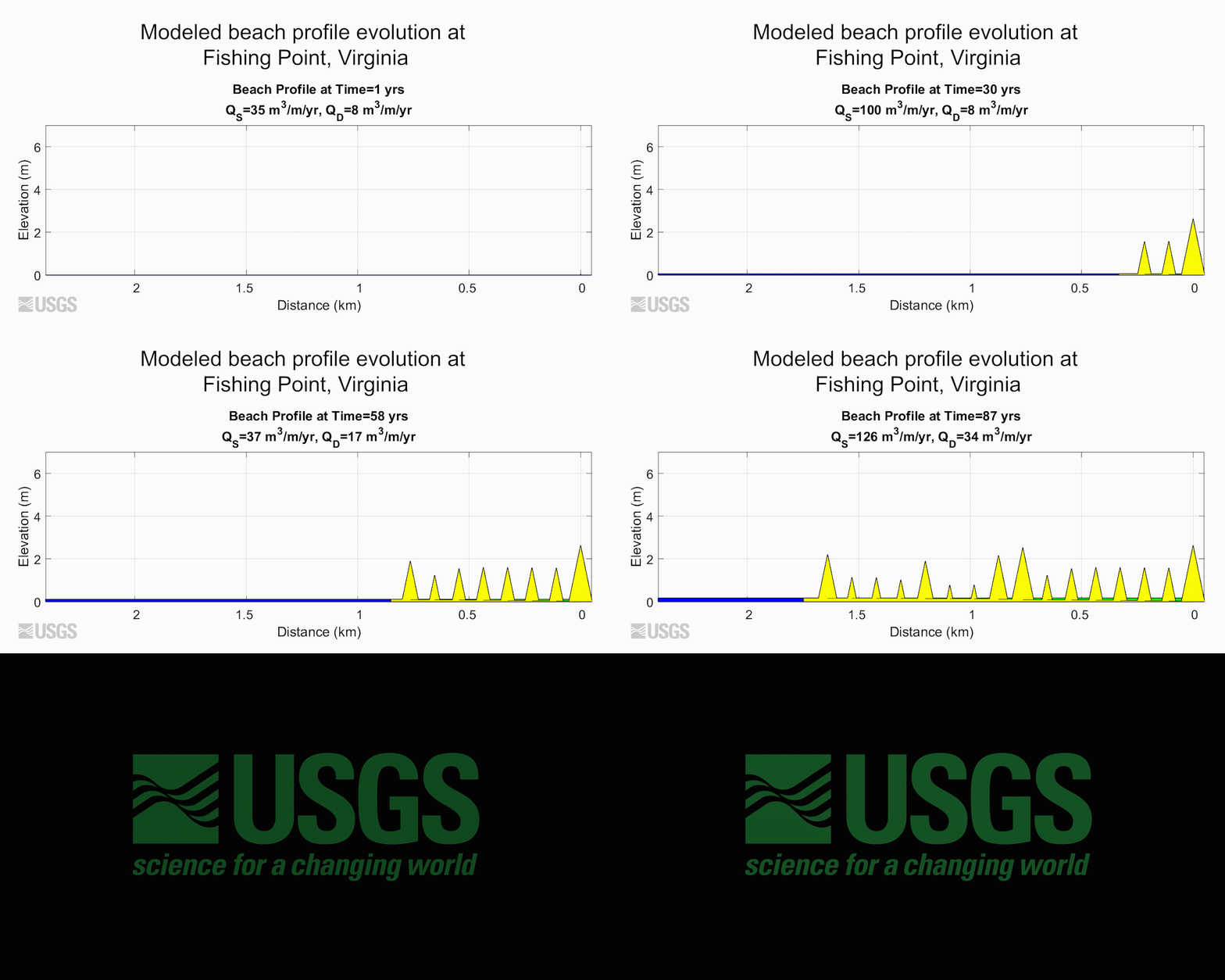
Modeled beach profile evolution at Fishing Point, VirginiaAnimation displays modeled beach profile elevation as it has evolved at Fishing Point, Virginia. These data are based on historical charts and images and measure distance (in kilometers) of cross-shore accretion. QS is the flux of sand to the beach, and QD is the flux of sand from the beach to the active dune.

SPCMSC Library
Rows of scientific journal articles housed within the library at the USGS St. Petersburg Coastal and Marine Science Center.
Rows of scientific journal articles housed within the library at the USGS St. Petersburg Coastal and Marine Science Center.

Lesson plan key for identifying coral condition
Key used in an educational lesson plan for identifying the composition and condition of corals and coralline algae in a core. (a) Two examples of Pocillopora in good taphonomic condition (<50% erosion or encrustation of the skeleton).
Key used in an educational lesson plan for identifying the composition and condition of corals and coralline algae in a core. (a) Two examples of Pocillopora in good taphonomic condition (<50% erosion or encrustation of the skeleton).