U.S. flag

An official website of the United States government

Images

St. Petersburg Coastal and Marine Science Center images.

Filter Total Items: 745
USGS DUNEX geophysical survey underway off of a USACE amphibious vessel in Duck, North Carolina
USGS DUNEX Survey underway off of a USACE amphibious vessel

A geophysical instrument (chirp) is towed in the water (yellow instrument) from a floating sled to acquire information about the geology below the seafloor in Duck, NC as part of DUNEX. The USACE Field Research Facility can be seen in the background in the upper left corner.

A geophysical instrument (chirp) is towed in the water (yellow instrument) from a floating sled to acquire information about the geology below the seafloor in Duck, NC as part of DUNEX. The USACE Field Research Facility can be seen in the background in the upper left corner.

A sandy beach and groin with buildings in the background at Seven Mile Island, New Jersey
Beach and groin at Seven Mile Island, New Jersey

A groin at Seven Mile Island, New Jersey traps sand and contributes to widening of the barrier beach. This illustrates how human modification and wave processes shape the beach. In May 2021, Andrew Farmer, Chelsea Stalk, and Emily Wei conducted a multibeam bathymetry survey offshore of Seven Mile Island, along the southern coast of New Jersey.

A groin at Seven Mile Island, New Jersey traps sand and contributes to widening of the barrier beach. This illustrates how human modification and wave processes shape the beach. In May 2021, Andrew Farmer, Chelsea Stalk, and Emily Wei conducted a multibeam bathymetry survey offshore of Seven Mile Island, along the southern coast of New Jersey.

A utility task vehicle parked on a beach with plants in the background, seaweed on the ground, and a cloudy sky above.
UTV in front of beach scarp

UTV (utility task vehicle) parked in front of a beach scarp used to collect data that is used in cooperation with FWC, FWS, USGS, and USFSP to understand sea turtle nesting behavior in response to beach renourishment with the goal of advising engineers on how to develop more turtle friendly nourishment desig

UTV (utility task vehicle) parked in front of a beach scarp used to collect data that is used in cooperation with FWC, FWS, USGS, and USFSP to understand sea turtle nesting behavior in response to beach renourishment with the goal of advising engineers on how to develop more turtle friendly nourishment desig

two people with SCUBA gear in the water next to a scientific instrument on the surface
Divers prepare to deploy ADCP

Scientific divers BJ Reynolds and Hunter Wilcox prepare to lower an Acoustic Doppler Current Profiler (ADCP) into the water. The ADCP now sits on the bottom of the ocean off Madeira beach, Florida in 5m water depth.

Scientific divers BJ Reynolds and Hunter Wilcox prepare to lower an Acoustic Doppler Current Profiler (ADCP) into the water. The ADCP now sits on the bottom of the ocean off Madeira beach, Florida in 5m water depth.

Scientific equipment, including a box and a cylindrical object, attached to a green platform on the deck of a boat
ADCP ready for deployment

An Acoustic Doppler Current Profiler (ADCP) on the deck of the R/V Sallenger ready to be deployed in the water. The ADCP now sits on the bottom of the ocean off Madeira beach, Florida in 5m water depth.

An Acoustic Doppler Current Profiler (ADCP) on the deck of the R/V Sallenger ready to be deployed in the water. The ADCP now sits on the bottom of the ocean off Madeira beach, Florida in 5m water depth.

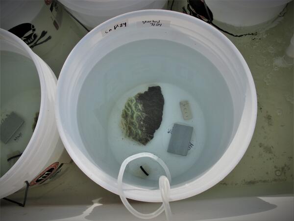
a coral fragment in a bucket, half white and half darkened
Testing the role of biofilms in the spread of stony coral tissue loss disease (SCTLD)

Biofilms are mats of microorganisms that stick together and form a layer, or “film,” on and within objects in the water—including ships—which could represent one possible mechanism for the spread of microbes (and potentially SCTLD’s unknown causative agent) from one region to another. To test this theory, scientists at the St.

Biofilms are mats of microorganisms that stick together and form a layer, or “film,” on and within objects in the water—including ships—which could represent one possible mechanism for the spread of microbes (and potentially SCTLD’s unknown causative agent) from one region to another. To test this theory, scientists at the St.

Two gray cylinders with chemical symbols next to a large metal cylinder labeled 'Nitrogen'
Gamma detectors at the St. Petersburg Coastal & Marine Science Center

Radioactive isotopes are common in nature and emit particles that can be detected, quantified, and used to characterize environmental processes.

Motion aerial view of several thin, sandy barrier islands lining a populated coastline behind an embayment
Aerial view of northern Pinellas County barrier islands

Barrier islands off the coast of northern Pinellas County, Florida including Anclote Key, Three Rooker Island, and the northern tip of Honeymoon Island. These barriers protect a highly populated coastline. 

An aerial view of several thin, sandy barrier islands lining a populated coastline behind an embayment
Aerial view of northern Pinellas County barrier islands

Barrier islands off the coast of northern Pinellas County, Florida including Anclote Key, Three Rooker Island, and the northern tip of Honeymoon Island. These barriers protect a highly populated coastline. 

Barrier islands off the coast of northern Pinellas County, Florida including Anclote Key, Three Rooker Island, and the northern tip of Honeymoon Island. These barriers protect a highly populated coastline. 

Beach ridges at Caladesi Island, FL
Succession of beach ridges, Caladesi Island, Gulf of Mexico coast, FL

Mendenhall postdoctoral fellow Daniel Ciarletta captured this view of the modern beach ridge system at Caladesi Island, along the Gulf coast of central Florida. Ciarletta and colleagues are studying the island as part of a project to explore barrier island response to long-term changes in sediment availability.

Mendenhall postdoctoral fellow Daniel Ciarletta captured this view of the modern beach ridge system at Caladesi Island, along the Gulf coast of central Florida. Ciarletta and colleagues are studying the island as part of a project to explore barrier island response to long-term changes in sediment availability.

A scientist sits on a personal watercraft near a vegetated, marsh shoreline.
Using personal watercraft to collect nearshore bathymetry data

A USGS scientist sits on a personal watercraft (PWC) equipped with scientific equipment to collect bathymetry data - or the depth of the water - at locations of interest in Point Aux Chenes Bay, Mississippi. 

A man holds a round, yellow object with a cord in front of a brick building
Dr. Mark Buckley holds a buoy used to collect oceanographic data
Two scientists operate a motorized cylindrical object as it penetrates a sandy marsh environment
Collecting sediment core with vibracore equipment at Mullet Key, FL

Dan Ciarletta (right) working alongside Julie Bernier (left) to collect a sediment core on Mullet Key, an island within Fort de Soto Park in Pinellas County, Florida. The core will be used to reconstruct the geologic history of the island.

Dan Ciarletta (right) working alongside Julie Bernier (left) to collect a sediment core on Mullet Key, an island within Fort de Soto Park in Pinellas County, Florida. The core will be used to reconstruct the geologic history of the island.

A scientist in a bright colored vest holds a chunk of consolidated sandy sediment, in a grassy area with palms behind them.
Sediment Sample from Barrier Island Core

Daniel Ciarletta, Ph.D. holds a chunk of sand from the bottom of a core collected at Fort de Soto Park in Pinellas County, Florida. Learn more about what barrier island cores tell us: https://www.usgs.gov/media/videos/secrets-sediment-barrier-islands.

photograph of a beach at the Cape Cod National Seashore with two humans walking with a balloon against dunes in the background
Helikite Surveying
Helikite Surveying
Helikite Surveying

The Helikite in action, being walked by USGS scientist Chris Sherwood and WHOI scientist Peter Traykovski, the helium powered balloon kite will be used to survey the DUNEX experiment site.

The Helikite in action, being walked by USGS scientist Chris Sherwood and WHOI scientist Peter Traykovski, the helium powered balloon kite will be used to survey the DUNEX experiment site.

USGS geologists surveying the beach at Caladesi Island, FL
Surveying the Beach at Caladesi Island, Gulf of Mexico Coast, Florida

Mendenhall postdoctoral fellow Daniel Ciarletta and geologist Julie Bernier perform field reconnaissance at Caladesi Island, along the Gulf coast of central Florida. The scientists are refining a plan to sample and survey the island using sediment vibracores and ground-penetrating radar.

Mendenhall postdoctoral fellow Daniel Ciarletta and geologist Julie Bernier perform field reconnaissance at Caladesi Island, along the Gulf coast of central Florida. The scientists are refining a plan to sample and survey the island using sediment vibracores and ground-penetrating radar.

USGS hydrologic technician holding a bottle containing a sediment sample
USGS technician holding a bottle containing a sediment sample

Hydrologic Technician Alan Cressler holding a bottle containing a sediment sample. Photo taken on the Caloosahatchee River below Structure 77, Moore Haven, Florida.

Coral on a cinderblock and a scuba diver on a coral reef
USGS scuba diver on a coral reef in Dry Tortugas National Park

The U.S. Geological Survey is conducting research to guide the recovery of the threatened Elkhorn coral, Acropora palmata, in Dry Tortugas National Park and throughout the western Atlantic.

Was this page helpful?